Tagged: redevelopment
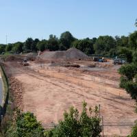
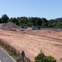
I'm in the habit of going over to the Tobacco Factory Market on a Sunday. I think I've walked all the routes around that way, but as a Plimsoll Bridge swing let me cross the road to the far side of Brunel Way on my return journey and I took a couple of photos of the brownfield development at the old Ashton Gate Depot site I thought I'd call it a Wander and pop some photos up.
I walked back to the point I'd spotted all this activity from the far side of the road. This is the old tile merchant/concrete works/Ashton Gate Railway Depot/Bristol International Exhibition site. I imagine it was plenty of other things along the way, too. Here's an earlier snap with a bad photo from the far side of the site, but some detail on what the site was/will be along with a link to planning documents.
I'm currently toying with the idea of a little mini-website that takes a digitised and vectorised version of the Bristol International Exhibition plan (from 1914) and superimposes it on the same area today. It'd be interesting to see exactly where things were. My best guess from eyeballing it at the moment is that in 1914, this view would be looking towards the International Pavilion, Concert Hall and Art Gallery areas of the Exhibition, and we'd be standing on the train tracks that used to head for Ashton Avenue Bridge, which back then would have been a double-decker road and rail swing bridge, with the trains on the ground level deck, the road on the top deck, and a high-level swing control room above it all. Quite some feat of engineering.
I wonder how many different things this patch of land has been over the years? I imagine it was one of the choice "brownfield" sites for some new flats down here. It's certainly doing its best to look very "brownfield" today!

