Tagged: track
I mostly went out to hang out with my friends Sarah and Vik in Bedminster, but along the way I thought I'd take a closer look at something a little nearer home: the last crossing point of the Rownham Ferry.
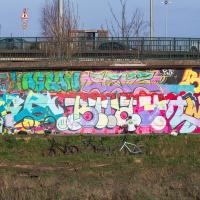
Much as I admire Sylvia Crowe's ambitious vision of her landscaping of the area the more I hear of it, I'm firmly in the camp who thinks the concrete now just looks grim and virtually anything improves it. I mean, it's not my cup of tea, but at least it brightens the dinginess up a bit.
A Coffee and a Curve
27 Mar 2022
I wanted to have a wander along to the Tobacco Factory Market for some shopping, and checking the map for any leftover nearby streets I noticed a tiny curve of road on the way into the modern flats at Paxton Drive that it didn't look like I'd walked down before. I wouldn't take me too far out of my way, so I decided to head there first and then across to North Street to get my groceries and a coffee...
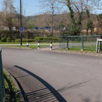
Here we are at the tiny loop of road that looked like it hadn't been walked. It has very little to recommend itself in any other capacity.
Paxton Drive always reminds me of Blake's 7, but in fact in the episode Stardrive it's actually Doctor Plaxton's drive that's the MacGuffin.