Here's the BBC report. This was posted on a telephone junction box in the "Daveside" area, the little strip of Festival Way that's used as a skate park in between the old railway depot and the White City allotments.
Taken: Tue 28 December 2021 13:39
Rating: ★★
GPS Coordinates:
51.44523, -2.62443
Neighbourhood: Bower Ashton
Street: National Cycle Route 33
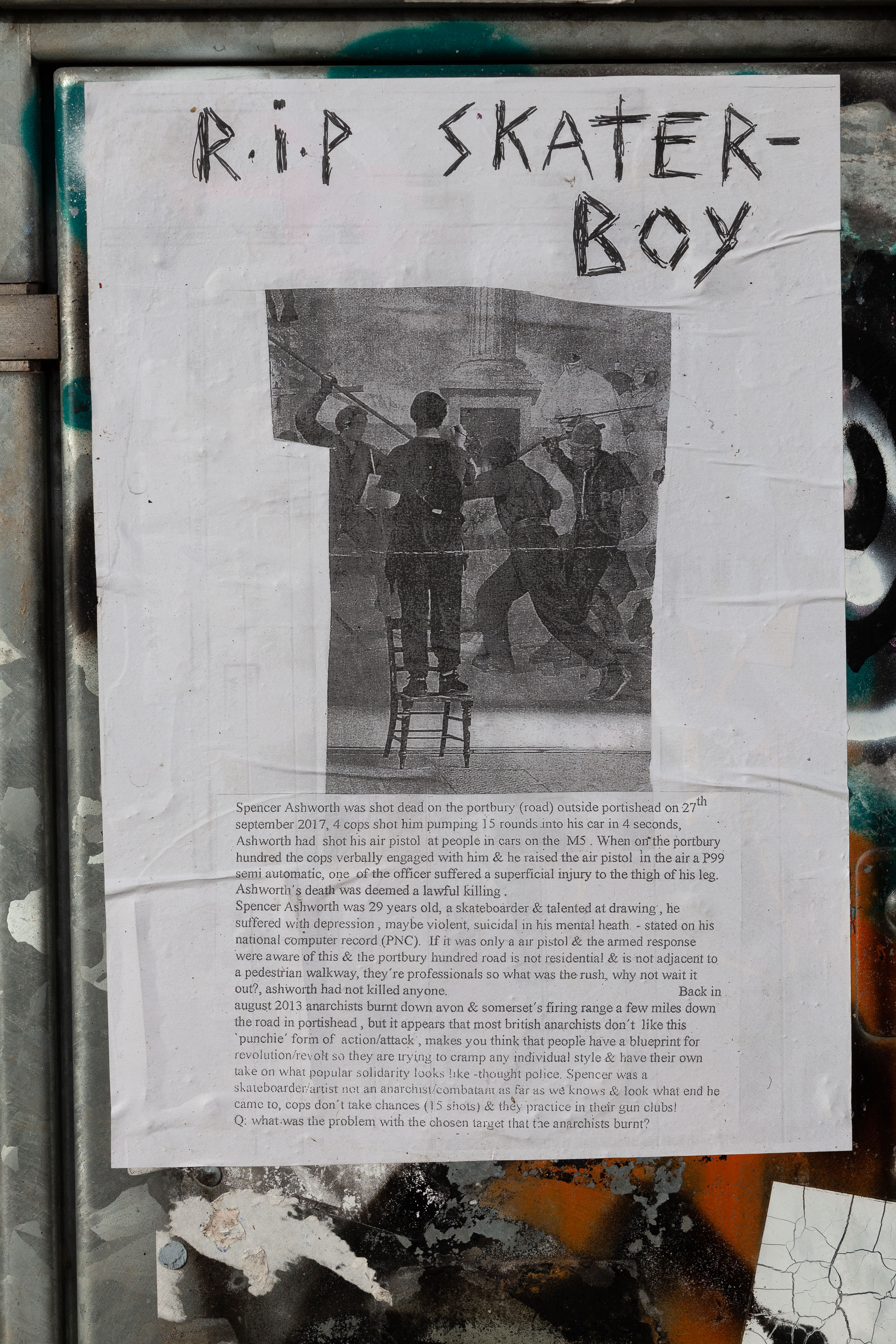
Tags: Bristol Places UK onemilematt united kingdom Daveside Festival Way skater Rownham RIP poster shooting skater boy
Auto-Tags: Handwriting Font News Newsprint Pattern Paper Paper product History Newspaper Signage Art Advertising Illustration Visual arts Monochrome photography
Text Recognition Tags: RiP SKATER- BOY Speer Astrworth wes shot dd on the pontiy troli oursida poroed on a parmbar 217, fo ot hum panpiag randa n ha car ecnde, Ashwent had stchn r pist at peple in te M Whes otde pertbary Sandred the copa vabully engged ith him & te id the sir pial in duar a amade, al dhe afficeatfaruda vapeifical ary m t igh efis teg Aalwedia does dieeda lantal illing Spee sd wa 29 ywars ol asato alested at dowing. te sffint win dprnmte det aliemal hth-sad on a at copoerad (PC) W t r j amed repose won aweof tis& he porta holstd i letal s t padori alhiy, they'e pafeial whe was the radt why na wait t o, atwodk ad or allad avass gat 20 rchis ft dowaon& seeettinng afar milm ikrwn ths road in pa el, btitapoevs iss aterchn don's lon hi bundie arm ef snk, nak yu thik tht people luallpere fer elationte ee ndaal sls hatir awe e on wha nie dity lo e tg lse Se waa shelebar uM onl fard koe lesk wtut t e d n I& th d adal Owturid ptn k da taerthatte ahin buar Boh RiP SKATER- BOY Speer Astrworth wes shot dd on the pontiy troli oursida poroed on a parmbar 217, fo ot hum panpiag randa n ha car ecnde, Ashwent had stchn r pist at peple in te M Whes otde pertbary Sandred the copa vabully engged ith him & te id the sir pial in duar a amade, al dhe afficeatfaruda vapeifical ary m t igh efis teg Aalwedia does dieeda lantal illing Spee sd wa 29 ywars ol asato alested at dowing. te sffint win dprnmte det aliemal hth-sad on a at copoerad (PC) W t r j amed repose won aweof tis& he porta holstd i letal s t padori alhiy, they'e pafeial whe was the radt why na wait t o, atwodk ad or allad avass gat 20 rchis ft dowaon& seeettinng afar milm ikrwn ths road in pa el, btitapoevs iss aterchn don's lon hi bundie arm ef snk, nak yu thik tht people luallpere fer elationte ee ndaal sls hatir awe e on wha nie dity lo e tg lse Se waa shelebar uM onl fard koe lesk wtut t e d n I& th d adal Owturid ptn k da taerthatte ahin buar Boh
Image copyright © Matt Gibson 2021