Tagged: m
Bocye's Avenue Windows
19 May 2021
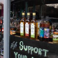
I just nipped up to Clifton Village to get a coffee, though I did manage to walk down a little alleyway I'd not really noticed before. Or perhaps I had noticed it and it looked private, but today I felt like wandering up its twenty or so feet anyway... The reflections in the shop windows on Boyce's Avenue gave me the idea to take a few snaps of them, so that's the majority of my small amount of snapping today.
Sequel Injection
07 May 2021
I saw this tweet the other day and started thinking of my second Covid-19 vaccination as my "Sequel Injection" (to a geek, it's funny. You'll have to take my word for it.) Whatever you call it, this morning I went and got it.
It was in the same place I got my initial injection—my left arm! No, okay, it was at the Clifton College Prep School. I didn't take any photos of the event itself; the NHS production line is so efficient you barely have time to do anything else, even if the privacy of other patients wasn't a factor.
Along the way I mused at all the road resurfacing going on in Clifton, and also discovered a secret (okay, not-well-known and possibly slightly trespassey) way into Canynge Square, and on the way back I knocked off a few streets from my "leftovers list" of north-east Clifton. I've got much of Clifton done now, with the only obvious "to dos" on the east side of Whiteladies Road...
It was quite a long walk, and I'm feeling pretty tired now, though that might be the effects of the jab too, I suppose. Anyway. Tomorrow and Monday I'm walking outside Bristol, I think, and I imagine my feet will need some recovery time on Sunday, so it might be a while before I post another Wander.
Canons Marsh Coffee Trip
29 Apr 2021
Another quick excursion to Canon's Marsh, tempted back by Rod & Ruby's cannoli and flat white. This time I poked around some bits of the modern flats I'd not really experienced before, mused on the old gasworks, and headed back down the Hotwell Road, spotting a re-opening gallery and finishing off at the Adam & Eve, for which some locals are currently rushing to launch a bid to turn it into a community business rather than have a developer turn it into yet-more flats.
I was in a bouncy, positive mood, helped out by Life Without Buildings' Live at the Annandale Hotel album1. Note to self, though: the album is nearly an hour long, so if you hear the encore starting and you're still halfway down the Hotwell Road, you'll probably be late back from lunch...
1 That review's well worth a read. Music journalists tend to go extra-dreamy when trying to describe Sue Tompkins. See what I mean:
She circles her limber tongue-twisters, feints, and attacks from unexpected angles, dicing and rearranging them with the superhuman brio of an anime ninja and a telegraphic sense of lexical rhythm.
Clifton Village, including Oxford Place
15 Feb 2021
I've noticed Oxford Place as a tiny little side/back road I've overlooked on my wanders a few times. Today I decided to pop down and have a look, as well as taking a few general snaps of Princess Victoria Street, which I thought deserved more pictures, as it's basically my closest decent shops, and in the Beforetimes I'd visit the Co-Op up there all the time, as well as the cafes (you'll be missed, Clifton Village branch of Boston Tea Party, recently closed in favour of Eat a Pitta.)
I'm definitely becoming more familiar with the area through the One Mile Matt jaunts and associated reading. Today I didn't just think, "oh, I'll head home down that weird alleyway with the electrical substation in it"—no, I thought, "I'll head home down Hanover Lane", because I actually knew its name. And on the way back from there I nodded sagely to myself as I passed St Vincent's Road, knowing now which St Vincent it's likely to be (St Vincent of Saragossa) and also eyed up the modern flats on Clifton Vale and wondered if they might have been built on the site of the former Vauxhall Pleasure Gardens... I don't know all the answers, but at least I have some idea of the historical questions I'm interested in.
Last time I was in I saw a jazz gig in the back room. It wasn't entirely my cup of tea, but hey, it was better than being cooped up at home for a year, so Yay! for the Beforetimes.
In Between
06 Feb 2021
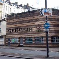
A lovely walk in the early spring sunshine with my friend Lisa. We headed directly for Jacobs Wells Road, to start off around the scene of one of our earlier walks, but this time took in Jacobs Wells from QEH upward, stopping to snap some photos of a Bear With Me, some interesting areas between Park Street and Brandon Hill including a peculiarly quiet enclave with a ruined old build I'd never found before, then crossed the Centre to grab take-away pies from Pieminister (I had the Heidi Pie) and head back to my place down the harbourside.
Very Brief Hotwells Wander
18 Feb 2021
Really just a quick loop of the Cumberland Basin. I was going to go further, and it was a nice early spring day, but I hadn't slept that well and I wasn't really in the mood. Ah well. Not every walk is great. At least I got out of the house for a bit.
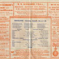
Since setting up a search for Hotwells on eBay I've mostly managed to restrain myself from buying much (or in one case, was outbid, luckily for my finances.) However, I couldn't resist a 1902 flyer for a singalong at the Terrett Memorial Hall, which would have stood five minutes' walk from my flat, overlooking Howard's Lock.
I've found out a fair bit about this non-denominational seaman's mission, including tracking down both a Loxton drawing and an aerial photo of it. The main thing that's eluded me, ironically enough, is finding out who Terrett was, so as a Memorial Hall it didn't do a very good job 😀.
EDIT: Ah! Did a little more digging and found that the Bristol Archives has a Bristol Dock Company document on file called "William Terrett, Esq.; corresp. etc. re proposed erection of a Mission Hall at Cumberland Basin, 1892", so that might be worth a look once the Archives are properly open again. Given that:
Sarah Terrett died suddenly on 25 November 1889, aged 53, after speaking at a meeting of the White Ribbon Army, the temperance organization she had founded in 1878. Following her death many people sent letters of sympathy to her bereaved husband, William. One of these, from the Rev. W. F. James, a minister of the Bible Christians, makes for especially interesting reading. The Bible Christian denomination, to which Sarah and William belonged, was one of the smaller Methodist connexions, and had its heartland in rural Devon, the area where she had grown up. James recalled the hospitality he enjoyed when visiting the Terretts’ home, Church House, in Bedminster, south Bristol...
...I wonder if William Terrett built the hall in memory of his late wife. They were clearly just the kind of temperance movement people who would've founded a seaman's mission to get people together to have a nice non-alcoholic singsong rather than a night out on the tiles.
Anyway. This walk to grab a coffee from Hopper Coffee in Greville Smyth Park was mostly an excuse to post the leaflet, a few other things I found related to it, and some pictures of how the site looks now. I would suggest that the present day is not an improvement.
I find the adverts fascinating. My first optician in Bristol was Dunscombe's on St Augustine's Parade, so they were there a long time. They've closed now (or at least moved) but were still there as recently as 2008, I think. Interesting to see gas lighting systems being advertised, too!
Better Look at an Extension
14 Apr 2021
Apart from a lovely coffee and a slice of Victoria sponge from Twelve, there weren't any new sights on this little lunchtime jaunt except for a slightly better look at the long raised extension at the back of the St Vincent's Rocks Hotel, where I at least got to see the arches it's raised up on. I also got a fair bit of exercise by walking up the Zig Zag to get there, and saw far more people out than I have in months, what with the lockdown having just been significantly lifted. As I walked past The Mall pub they were turning people away from their already-full garden, and the (outdoor) cafe tables were pretty full up.
Long Bemmie Wander with Lisa
11 Apr 2021
My friend Lisa joined me again, this time for a long wander through "Bemmie". In fact, I tweeted recently using "Bedmo" as my abbreviation for Bedminster, and apparently there's something of a culture war going on. From what I can glean, the longer-term residents call it "Bemmie" and consider "Bedmo" a name made up by hipster gentrifiers.
I had no idea, but then I didn't grow up around here, and I don't live in Bedminster, and I'm not a hipster. I'm not sure I've ever gentrified anywhere, either; Hotwells was already quite gentrified by the time I arrived. I probably just lowered the tone a bit.
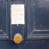
Anyway. Lisa and I entered Bemmie by the traditional toll gate (though actually you'd only have paid if you were coming from the Long Ashton direction, not merely nipping across from Hotwells) and then almost literally combed the streets to knock several new roads off my list of targets. Along the way we saw lots of street art, as you'd expect, and admired the area's panoply of gorgeous knockers.
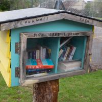
My theory that every free library has at least one Lee Child or Dan Brown novel has yet to be disproved. Station Eleven's a great book, though.
An Evening Wander to the Gallows
06 Apr 2021
I'd originally intended just to pop up to the area around Alma Road, where I'd missed a few streets on earlier wanders. It was such a nice evening, though, I decided to extend my walk up to the very top of Pembroke Road, just outside my one mile radius, to take a few snaps of something intriguing I'd found in my researches.
I've driven, walked and jogged past the little triangle of land at the top of Pembroke road a great deal in my time in Bristol, but I didn't know that it used to be the site of a gibbet, in fact that the road itself there used to be called Gallows Acre Lane. According to the Durdham Down history trail, by Francis Greenacre (an excellent name for a Downs researcher!) among other sources:
...it was below this quarry near the top of Pembroke Road, once called Gallows Acre Lane, that a gibbet stood. It was sometimes occupied by those who had committed robberies on the Downs and was last used in 1783 to hang Shenkin Protheroe for the murder of a drover. Stories quickly spread that he descended from the gibbet at midnight every night and stalked through Clifton. Such was the alarm that his body was cut down
and buried.
Also very close to this little triangle of land was one of the gates of the extensive turnpike system...
Anyway. Along the way I encountered a wooden tortoise and a real squirrel, among other things. It was a good walk, and more light in the evenings means I can move my wanders out of the ticking countdown clock of work lunch-hours and be a bit more leisurely.
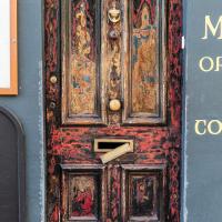
It's a great door, and I really couldn't find the best way of capturing it. Ah well.
