Tagged: cemetery
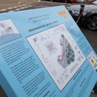
Jacob's Well Wander
01 Feb 2021
I just wanted to get some exercise, really, so I set out to knock off the lower bit of Jacobs Wells Road that I'd not managed to walk up yet. I set the new signboard that the community association had had erected as my destination, after reading about it on their blog.
As it turned out, I couldn't even read it, as the building that houses the actual Jacob's Well had water flooding out onto the pavement. I wonder if it was actual Jacob's Well water? Have the soles of my walking shoes been mystically blessed now?
You can't see much of the flood in the photos I snapped, but I did shoot a little video, too. Ed on Twitter said:
I spoke to the seller at the time with a view to buying it - I mentioned an old friend who grew up nearby remembers it flooding regularly. He swore blind my friend was wrong.
Little Clifton Village Details
09 Nov 2020
I like The Paragon as a terrace, especially the bowed porches. On the other side of the road, a house attic has a stone lion surrounded by rocaille leaves, according to its listing.
I also love the detail of the arrows in the wrought iron of The Mall's balconies. Today I discovered Westfield place, a road I'd never encountered that runs up to the rear of the Coronation Tap. (It's a famous local cider pub, but I've only been in a couple of times. I'm more of a beer man.)
Outside the Zone
01 Nov 2020
This started as a little local walk with my friend Lisa, but when we randomly met my friends Sarah and Vik at Ashton Court, turned into joining them for a very long wander out to Abbots Leigh Pool. Most of this was well outside my one-mile radius but it was a lovely walk.
Dowry Square Jaunt
16 Nov 2020
A quick lunchtime jaunt to Dowry Square, which is very close to me but, being effectively a cul-de-sac as well as a square, I've probably only circumnavigated a couple of times in the last couple of decades.
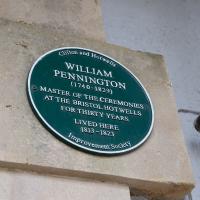
From The Bristol Hotwell, by Vincent Waite:
The Bristol Hotwell was, of course, much smaller than the neighbouring spa of Bath, and it was in no sense a rival but rather a supplementary cure, for many people combined visits to the two resorts. After 1785 the Hotwell imitated Bath by appointing a Master of Ceremonies, "William Pennington Esquire," who wore a gold medallion strung on a blue ribbon to emphasise the dignity of his office. In order to preserve decorum in the public entertainments he issued the following regulations:
- That a certain row of seats be set apart at the upper end of the room for ladies of precedence and foreigners of fashion.
- That every lady who has a right of precedence deliver her card to the Master of Ceremonies on her entering the room.
- That no gentleman appear with a sword or with spurs in these rooms, or on a ball night, in boots.
- That on ball nights when minuets are danced, ladies who intend dancing there will sit in a front row for the convenience of being taken out and returning to their places.
- That on all occasions ladies are admitted to these rooms in hats, not excepting the balls given to the Master of the Ceremonies.
- That the subscription balls will begin as soon as possible after 7 o'clock and conclude at 11, on account of the health of the company.
- It is earnestly requested that when a lady has gone down the dance she will be so polite as not to retire till it is concluded.
Jaunt to a Closed Coffee Shop
17 Nov 2020
A fruitless wander, as Spoke and Stringer (who I thought might do a decent flat white) were closed, and the only other harbourside inlet offering were a bit too busy to wait at, especially as I'd spent some time wandering some of the convolutions of Rownham Mead. This last congeries of dull alleyways and brown-painted garages was at least somewhere I've never been before, in parts.
A bethel ship was a kind of floating church; it would moor up near other ships and the sailors could board it for worship.
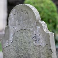
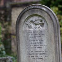
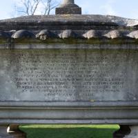
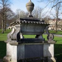
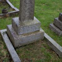
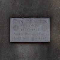
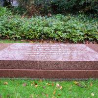
Strangers' Burial Ground
04 Dec 2020
I tried to find the Strangers' Burial Ground the last time was up in Clifton, but I'd not realised that Lower Clifton Hill continues further on after the turning with Constitution Hill. Sadly it was chained shut, but it still looks beautifully-maintained, perhaps by the same man referenced by this story from John Hodgson, which helped me find it. Apparently Thomas Beddoes is buried here.
He sounds... a little unusual. Just to be clear, it's the pederasty I'm frowning at, not the homosexuality.
Rainy Clifton
13 Dec 2020
A long walk around Cliftonwood and Clifton with my friend Lisa, taking in some of the 12 Days of Christmas display at Queens Parade, picking up a take-away coffee from Pinkmans of Park Street, and poking our heads up against the glass of SS Peter and Paul Catholic Cathedral.
As ususal with religious stuff, I've just looked up what a protonotary is and am really none the wiser.
Cliftonwood and Clifton Village Lunchtime Stroll
14 Dec 2020
The lunchtime walk has been feeling a bit of a chore lately, especially as I only have an hour and have to keep a mental watch out for my "bingo" point or risk being late back. Today I went for a deliberately brief local walk and got home in time to have lunch on my sofa rather than while I was back at work.
It's interesting filling in the gaps in my Clifton Village knowledge, especially starting to "see" the bits I can't see, the negative spaces. The size of both Fosseway Court and the Bishop's House gardens (check out the latter on Google Maps for an idea) are both something I've noticed by just getting to know the areas around them. I may also have to walk into the driveway of the very well-hidden Nuffield hospital to get an idea of how big it is.
None of those are anything compared to the trick of hiding the gargantuan public school that is Queen Elizabeth's Hospital so well that I keep on forgetting it's there, until a glimpse of it from somewhere like Lower Clifton Hill reminds me about it, of course...
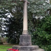
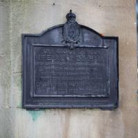
War Memorial, approriately next to the remaining foundations of St Andrew's Church, destroyed by bombing in 1940
Snowy Leigh Wander
24 Jan 2021
I started this wander with my "support bubble" Sarah and Vik, after Sarah texted me to say "SNOW!" We parted ways on the towpath and I headed up into the bit of Leigh Woods that's not actually the woods—the village-like part in between Leigh Woods and Ashton Court, where I'd noticed on a map a church I'd not seen before. I found St Mary the Virgin and quite a few other things I'd never experienced, despite having walked nearby them many, many times over many years, including a castellated Victorian water tower that's been turned into a house...
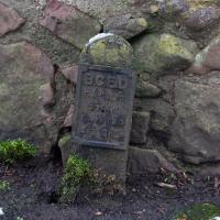
Some kind of electrical marker, I think -- BCED is most likely to be Bristol Corporation Electricity Department. Probably an underground cable marker.
Downs Wander
23 Feb 2021
Just a quick trip to knock off a path or two on Clifton Down. I'm not actually convinced I walked down the paths I was hoping to, but I suppose I'll see once I upload this and look at it on the map :)
Today's highlight turned out to be retrospective—looking up Gertrude Hermes' amazing wood engravings when I got home. (By complete coincidence, I was trying to discover the location of the Stella Matutina's former Hermes Lodge in Bristol as part of my researches last night...)