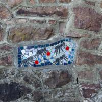
Tagged: rock
The more I research it, the more I find that Hotwells had far better transport links back in Victorian and Edwardian times than it has today. Along with buses that went to more useful places than the City Centre, there were trams, the funicular up to Clifton, the landing stage for paddle steamer services and two railway stations all within easy walking distance of me.
Today I took a day off work as preparation for doing the bookkeeping for my tax return1, and took a wander along to the site of what would have been my nearest station, Hotwells (or Clifton, as it started out in life), nestled in the shadow of the suspension bridge, the Bristol terminus of the Bristol Port Railway and Pier.
From there I wandered down the Portway, following the original line, until I got to the area around Sneyd Park Junction, where the tunnel from the slightly later Clifton Extension Railway joined up with this originally-isolated BPR line. Then I headed up to Clifton through the "goat gully" at Walcombe Slade, seeing the few above-ground bits of evidence of the tunnel (which is still in regular use) along the way.
It was a lovely day, and a good walk, and it was interesting to daydream of the times when I could have walked a few minutes from my flat down to Dowry Parade, caught a short tram ride to Hotwells Stations, and then headed from there to Avonmouth, perhaps even to board a transatlantic passenger service. The completion of the Clifton Extension Railway that linked the Avonmouth station with Temple Meads made relatively direct transatlantic travel from London via Bristol possible, with passengers travelling up from Paddington to Temple Meads, on to Avonmouth on the Clifton Extension Railway and Port Railway and Pier line, then perhaps catching a Cambpell's paddle steamer—which sometimes acted as tenders for large steamers—to a larger ship that was headed out for Canada, say.
1 I've learned that the best approach is to take two days off and deliberately do something that's not my bookkeeping on the first day, as otherwise I just inevitably end up procrastinating and feeling guilty on the first day no matter what. I have an odd brain, but at least I'm learning strategies for dealing with its strange ways as I get older...
2 Information mostly gleaned from Colin Maggs' The Bristol Port Railway & Pier and the Clifton Extension Railway, The Oakwood Press, 1975.
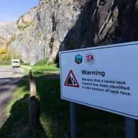
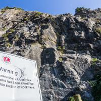
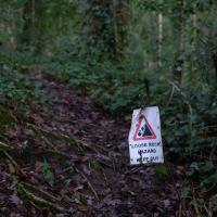
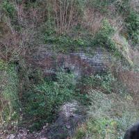
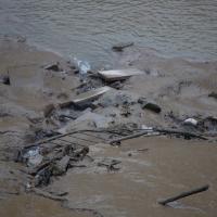
This is known for being something of a fragile area. Here's a picture of the earlier dangerous face being blasted away in the summer of '76, to stop it falling on the Portway. Every year the Portway is closed for a day or two to allow for a close inspection that can lead to the planning of remedial works. I'll often get a bit of notice of this, as they have to put the warning signs up quite early down in Hotwells so people can plan their alternative routes.
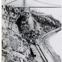
This photo comes from the M Oakley Collection via a scan from Branch Lines Around Avonmouth, by Vic Mitchell and Keith Smith, ISBN 190447442X. My reproduction quality isn't great, but hopefully you can see Hotwells Station as it was in its early years, including the turntable at the far end, just in front of the stationmaster's house, to the left of the booking office.
Later the turntable was removed and the tracks extended all the way to the end to make the most of the limited platform space; the engine would move onto the centre run-around track in advance, then pull the carriages into the station on the other track using a draw-bar instead of using the turntable to run around them after it had pulled them in.
My favourite tidbit from Colin Maggs' The Bristol Port Railway & Pier is the last bit here:
Around the turn of the century, a stationmaster at Sea Mills kept poultry, pigs, a cow and used his pony and trap to fetch swill from the docks. He sold eggs to passengers and provided the the Superintendent at Bristol with butter and new-laid eggs. Another character was a driver nicknamed ‘Mad Jack’. He enjoyed scaring the dockers to death by rushing through the tunnels into Hotwells, once misjudging his braking power and crashing into the buffers.
Must've been quite unnerving, racing out of the tunnel straight towards the cliff face at speed!
Of course there's graffiti in there. This was, apparently, used as a stable!
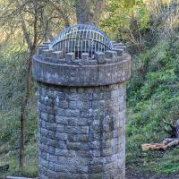
Further to improve the ventilation provided by the two vertical shafts, in 1950 an old shaft leading out to the face of the gorge was re-opened after having been blocked for many years. Originally it had been used as a stable for ponies employed in tunnel construction. A ganger's cabin is hewn out of the side of the tunnel and is on the down side approximately midway.
— Colin Maggs, The Bristol Port Railway & Pier and the Clifton Extension Railway, The Oakwood Press, 1975
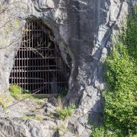
My historical research took a wander underground recently, partly inspired by the Canynge Square sinkhole, partly by St Vincent's (Ghyston's) cave and its tunnel to the Observatory, and I was surprised to find that there might be an intact tunnel from the Bristol Port Railway and Pier still just sitting there under Bridge Valley Road. A quick search turned up this recent video by an intrepid explorer, so it's definitely still there.
I went looking for the entrances today, and definitely found the south entrance, at the start of the Bridge Valley Path, the footpath that starts with steps at the bottom of Bridge Valley Road. It's easy to miss if you're not looking for it. I think I've figured out where the north entrance is, too, but it was getting dark at that stage and the Portway was still busy enough that crossing the road was still the normal nuisance, so I thought I'd leave further explorations for another day.
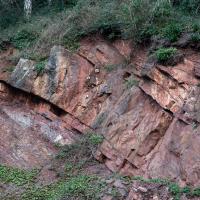
Every surface of the cliff face around here is basically bolted on to stop it falling into the road.
...and on the other side is the exit from the tunnel section closer to town. I don't know if that was also part of the Portnalls Number One tunnel or if it had a separate name. Either way, the railway would have run from Hotwells Halt on the city side all the way to Avonmouth, from what I can work out.
Outside the Zone
01 Nov 2020
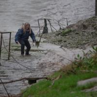
This started as a little local walk with my friend Lisa, but when we randomly met my friends Sarah and Vik at Ashton Court, turned into joining them for a very long wander out to Abbots Leigh Pool. Most of this was well outside my one-mile radius but it was a lovely walk.
Bedmo and Ashton Court
21 Nov 2020
A rather more wide-ranging weekend wander with Sarah and Vik, taking in some mock Tudor bits of Bedmo (I should note that I've subsequently been corrected to "Bemmie", but I'm an outsider and have been calling it "Bedmo" for short for decades...), a chunk of Ashton, a path up Rownham Hill called Dead Badger's Bottom(!), The Ashton Court estate, a bit of the UWE campus at Bower Ashton, and some of the Festival Way path.
And Back Down the Hill from the Flu Jab
21 Nov 2020
This is my return from getting my annual flu jab at Christ Church, as explained in more detail in my wander up the hill.

I don't think this is exactly a public right of way. But I started so I tried to finish without getting the police called on me by worried residents
The Long Lunchtime at the End of the World
27 Nov 2020
I took an extra-long break at lunchtime today as I'd taken the day off my normal day-job to do the accounts for my previous side-job, which is still generating paperwork, though not much in the way of money. This took me through some undiscovered bits of Cliftonwood, including Worlds End Lane, which unexpectedly leads to White Hart Steps. That's certainly not where I expected the end of the world to lead to...
A long ramble, starting with trying to find the Hot Well of Hotwells and leading up the side of the Avon Gorge to the Downs and then through Clifton for coffee.
Strangers' Burial Ground
04 Dec 2020
I tried to find the Strangers' Burial Ground the last time was up in Clifton, but I'd not realised that Lower Clifton Hill continues further on after the turning with Constitution Hill. Sadly it was chained shut, but it still looks beautifully-maintained, perhaps by the same man referenced by this story from John Hodgson, which helped me find it. Apparently Thomas Beddoes is buried here.
Alma Vale
06 Dec 2020
I wasn't really feeling it when I set out today, on my first car-assisted wander. By the time I'd parked on Alma Vale Road in Clifton it was just starting to rain and I picked my way about in quite a desultory way. It felt strange, as I was very familiar with the area because I'd walked through it hundreds of times when I worked at the top of Whiteladies Road, and used to walk up the hill from Hotwells and through Clifton to get there, and back again, every day.
Then a complete coincidence seemed to make the change I'd been hoping for. I was standing taking a photo of Christ in the front garden of All Saints church when a couple of people walked out of the front door. I got talking with a lady I took to be part of the ministerial team, who invited me to come in and look around—something I'd always wanted to do on the morning commute. (I think we connected a bit when I recognised the name John Piper, who did the amazing windows—I learned about him while I was at Warwick, through his connections to Coventry Cathedral.
I left with much more of a spring in my step, wandered around the area a bit more, finally working out that the tennis courts I used to pass every morning are those of Clifton Lawn Tennis Club, and finally grabbing an excellent Hungarian sausage hot dog from the Budapest Cafe. I feel a lot better now than I did before I went out.
Rainy Clifton
13 Dec 2020
A long walk around Cliftonwood and Clifton with my friend Lisa, taking in some of the 12 Days of Christmas display at Queens Parade, picking up a take-away coffee from Pinkmans of Park Street, and poking our heads up against the glass of SS Peter and Paul Catholic Cathedral.
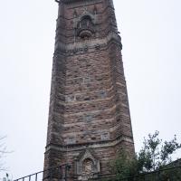
Cabot tower and the little garden surrounding it at the top of Brandon HIll have a feeling I think of as "Victorian magic". It's all a bit fairytale.