Tagged: rock
Museum of the Moon, and a Bit of Redland
21 Aug 2021
Lisa and I mostly went out to have a look at Luke Jerram's Museum of the Moon as its tour hit Bristol Cathedral—I missed it when it was previously in town, at Wills Hall, I think—but we also took a trek up to Redland. Lisa's kind enough to indulge my strange current fascination with the Edwardian eccentrics that made up the Stella Matutina, so we swung by a couple of places with a vague connection to the Bristol branch of the organisation. Well, it was good walking, anyway...
As a stunning bonus, one of the picture's descriptions has more information than you'd probably want on the Bristol Port Railway and Pier's Clifton Extension Railway line, but I did happen to coincidentally write up this wander after reading about the extension line during my lunch hour at work today. It's a thrilling life, I tell you...
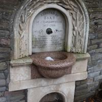
I was surprised to find that "thank-offering" is actually in Chambers' dictionary, and not at all surprised to find it means exactly what you'd expect.
The inscription is from Psalm 114:
Tremble, thou earth, at the presence of the Lord, at the presence of the God of Jacob; Which turned the rock into a standing water, the flint into a fountain of waters.
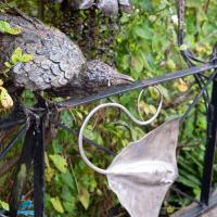
Mostly the Metal Animals of a Clifton Garden
30 Aug 2021
Lisa and I went for a longish walk, but I didn't take many photos. Mostly we just wandered and nattered. Unusually, my target was outside my 1-mile radius on Burlington Road in Redland, where I snapped quite a few photos of the collection of artistic animals by Julian Warren. This was mostly to provide a fairly arbitrary destination for a roundabout walk in Clifton...
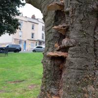
I'm no arborist. I have no idea whether the big-arse mushrooms growing from the side here are just plain old benign mushrooms or a symptom of the fungal infection that killed this poor old beech tree.
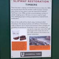
I'm afraid that this is a bit of a badly-curated wander, where I mostly just popped out to find out a little of the history of Underfall Yard and poke around the various open workshops, and, in hindsight, really didn't take pictures in any kind of coherent order. So there's a lot of pictures, but they don't really tell the story that, in hindsight, I seem to have been trying to tell, of the unusual electrical substation in Avon Crescent, the Bristol Electricity that predates the National Grid but is still in use, the history of the hydraulic power house... It's a bit of a mess.
But I suppose sometimes these wanders—always chronologically presented in the order I walked and took photos—simply will sometimes be a bit of a mess. Let's hope you still get something out of it, anyway...
The Gridiron and Bower Ashton Part Two
03 Dec 2021
On my last wander, to Bower Ashton, I was intending to knock Blackmoors Lane off my list "to-do" list, but got a bit diverted. I also took a little look into the history of the Gridiron, once a cheaper alternative to dry dock that was nestled just south of North Entrance Lock.
Today I had to go to send a parcel off somewhere, so I decided on going to the North Street Post Office via Blackmoors Lane. I didn't have much intention of anything else, but as luck would have it I walked out both at low tide and also as some lockkeepers seemed to be having a bit of a training session, and one of the more senior people was (a) happy to answer a few random questions on the Gridiron and (b) actually knew a lot about it, as Gridiron maintenance had been one of his jobs, more than twenty years ago...
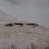
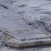
So, this is all that can be seen today of a 200-foot long, 38-foot wide grid of wood, I think—at first I figured it was metal, but Nick Howes posted a historic photo on Twitter where the grid itself certainly looks to be made of timber—hidden completely by a simple build-up of silt.
Up until the year 2000, it had been in use since some time in the 1890s, I think. Grace's guide's copy of the Institution of Civil Engineer's obituary of John McCurrich certainly attributes the construction of a gridiron to him while he was Docks Engineer for Bristol, and he held that post from 1890 until his death in 1899.
I mostly went out to hang out with my friends Sarah and Vik in Bedminster, but along the way I thought I'd take a closer look at something a little nearer home: the last crossing point of the Rownham Ferry.
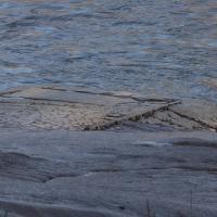
Now the tide's lower, we can see the end of the slipway we looked at earlier poking out from the Somerset side. According this article from the Bristol & Avon Family History Society:
In 1793 the ferry was identified as being used by many passengers to "cross the river at Rownham ferry and walk to the sweet and wholesome village of Ashton to eat strawberries and cream"
Looks like the stones at the bottom corner were replaced with some simple poured concrete with grip lines drawn across it at some point.