Tagged: harbour
Coffee and Graff
22 Jan 2021
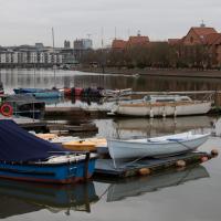
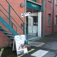
Took myself around the harbour to Imagine That's horsebox cafe and treated myself to a flat white and a sourdough cheese toastie. On the way there and back I encountered some local flooding and various bit of graffiti, from some ugly tagging on someone's front windows to a large new piece being added to Cumberland Piazza in the ongoing attempts to cheer the place up.
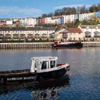
Tags: Bristol Places UK onemilematt united kingdom boat Clifotnwood Mariner harbour master
Auto-Tags: Water Boat Watercraft Sky Cloud Building Vehicle Lake Boats and boating--Equipment and supplies Body of water Bank Tree Morning Waterway Ship
Text Recognition Tags: R HARBOUR MASTEF R HARBOUR MASTEF
Shop Fronts of Regent Street
22 May 2021
I didn't even think I'd manage to get out today, such was the weather forecast. As it turned out, it's been quite a nice day, and I managed to nip up to Clifton Village to pop to the Post Office. As with my last outing, I decided after snapping one shop-front on Regent Street that I might as well snap the whole row, and muse on a few of them, the only service I really offer over and above Google Street View for a lot of my pictures 😀
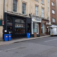
I think this replaced Pizza Provençal; they've got a much bigger branch on Whiteladies Road, which is the only one I've been to.
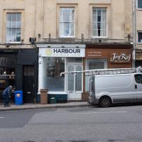
The Joy Raj do good food, from what I remember. I've never had any need for family law. Surprisingly, it was a hairdresser before it was a law firm.
Tags: Bristol Places UK onemilematt united kingdom Clifton Village Clifton shops businesses shopfronts
Auto-Tags: Wheel Window Property Tire Vehicle Vehicle registration plate Car Infrastructure Building Motor vehicle Compact van Light commercial vehicle Wall Automotive exterior Van
Text Recognition Tags: HARBOUR FAMILY Joy Raj HARBOUR FAMILY Joy Raj
A Cliftonwood Revisit with Lisa
10 Jul 2021
Lisa had a couple of hours to spare before going up in a hot air balloon (exciting!) so we went for a quick local walk, revisiting a bit of Cliftonwood we've seen before, exploring the secret garden I'd visited before that I thought she'd enjoy (I didn't take any new photos there) and then pushing on to another garden, Cherry Garden. Last time we passed this way, I'd noticed the gate, but we hadn't gone in as I'd assumed it was private. I'd since found it on CHIS's list of communal gardens in Clifton, so I wanted to have a look inside this time, and try to figure out whether it was private-communal or public, and possibly Council-owned, like several of the other gardens in Clifton.
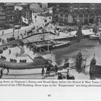
Photo taken from the book Bygone Bristol: Hotwells and the City Docks, by Janet and Derek Fisher.
You can see the gate from the previous photo at the start of Narrow Quay. Plenty of other changes in the area, too: the statue of Neptune stands at the head of the water; there are no Cascade Steps yet; cranes still stand on Broad Quay, and you can just about tell that there's still a main road running right across the middle of Queen Square in the distance.
The gate stands half-closed; presumably before the E and W sheds were converted into the cinemas, bars and restaurants of the Watershed and other publically-accessible attractions there was still some need to keep the (working) dockside a little more secure, and I'm guessing it might have been locked at night.
The gates are listed and have apparently been there since 1894.
Tags: Bristol Places UK onemilematt united kingdom City Centre history Centre Book Brian Lewis Bygone Bristol Hotwells and the City Docks Janet and Derek Fisher photos St Augustine's Quay
Auto-Tags: Urban design Adaptation Water Motor vehicle Boat History Watercraft Paper product City Stock photography Vehicle Landscape Mixed-use Holy places Pole
Text Recognition Tags: WILLS CAPSTAN CIGARETTES FLOATING HARBOUR, CITY CENTRE, BRISTOR 79 78. Looking down on Neptune's Statue and Broad Quay before the Bristol & West Tower Building and the removal of the CWS Building. River trips on the "Kingstonian" are being advertised. e 1951. 40 WILLS CAPSTAN CIGARETTES FLOATING HARBOUR, CITY CENTRE, BRISTOR 79 78. Looking down on Neptune's Statue and Broad Quay before the Bristol & West Tower Building and the removal of the CWS Building. River trips on the "Kingstonian" are being advertised. e 1951. 40
I'm afraid that this is a bit of a badly-curated wander, where I mostly just popped out to find out a little of the history of Underfall Yard and poke around the various open workshops, and, in hindsight, really didn't take pictures in any kind of coherent order. So there's a lot of pictures, but they don't really tell the story that, in hindsight, I seem to have been trying to tell, of the unusual electrical substation in Avon Crescent, the Bristol Electricity that predates the National Grid but is still in use, the history of the hydraulic power house... It's a bit of a mess.
But I suppose sometimes these wanders—always chronologically presented in the order I walked and took photos—simply will sometimes be a bit of a mess. Let's hope you still get something out of it, anyway...
A winch that can heft the Matthew up the Patent Slip is pretty impressive.
Tags: Bristol Places UK onemilematt united kingdom Hotwells Underfall Yard Spike Island Docks Heritage Weekend
Auto-Tags: Motor vehicle Font Gas Automotive exterior Signage Wood Poster Advertising Art Facade Automotive wheel system Tree Automotive tire City Metal
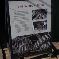
Text Recognition Tags: THE WINCH SHED The winding gnar and motor used to pull boats out of the water are in the Winch Shed at the top of the sipaay tt te hy y on the ich o Whn sv t he tat the pa y an The heu Jn nd MU HEART OF THE HARBOUR 22 THE WINCH SHED The winding gnar and motor used to pull boats out of the water are in the Winch Shed at the top of the sipaay tt te hy y on the ich o Whn sv t he tat the pa y an The heu Jn nd MU HEART OF THE HARBOUR 22
I only found out from a recent Times crossword that "shivers" are splinters.
Tags: Bristol Places UK onemilematt united kingdom Hotwells Underfall Yard Spike Island Docks Heritage Weekend
Auto-Tags: Motor vehicle Font Poster Signage Vehicle Advertising Landscape Soil Banner Recipe Sign Luxury vehicle Transport Aircraft Rock
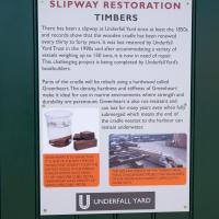
Text Recognition Tags: SLIPWAY RESTORATION TIMBERS There has been a slipway at Underfall Yard since at least the 1850s and records show that the wooden cradle has been renewed every thirty to forty years. It was last restored by Underfall Yard Trust in the 1990s and after accommodating a variety of vessels weighing up to 150 tons, it is now in need of repair. This challenging project is being completed by Underfall Yard's boatbuilders. Parts of the cradle will be rebuilt using a hardwood called Greenheart The density, hardness and stiffness of Greenheart make it ideal for use in marine environments where strength and durability are paramount. Greenheart is also rot-resistant and can last for many years even when fully submerged which means the end of the cradle nearest to the harbour can remain underwater. GREENHEART n so bevSETHAT THONE OFTHE EW TSOr WOOD THAT DORINT OATHE sornst WOO0INTHEWORLD BALSA WHCH HASA DEND TY OF 1KG R CUBIC ETRL CABINHEART HASA DNSITY OF ID40 KG PE CUBICHETR THE SZFANDwtICHT OFTHETHIEEMA THISA CHA vON HOECY THE TOUHES OF TH WOOD ALO HAEESIT DCAT TO WOM WITH UNDERFALL YARD SLIPWAY RESTORATION TIMBERS There has been a slipway at Underfall Yard since at least the 1850s and records show that the wooden cradle has been renewed every thirty to forty years. It was last restored by Underfall Yard Trust in the 1990s and after accommodating a variety of vessels weighing up to 150 tons, it is now in need of repair. This challenging project is being completed by Underfall Yard's boatbuilders. Parts of the cradle will be rebuilt using a hardwood called Greenheart The density, hardness and stiffness of Greenheart make it ideal for use in marine environments where strength and durability are paramount. Greenheart is also rot-resistant and can last for many years even when fully submerged which means the end of the cradle nearest to the harbour can remain underwater. GREENHEART n so bevSETHAT THONE OFTHE EW TSOr WOOD THAT DORINT OATHE sornst WOO0INTHEWORLD BALSA WHCH HASA DEND TY OF 1KG R CUBIC ETRL CABINHEART HASA DNSITY OF ID40 KG PE CUBICHETR THE SZFANDwtICHT OFTHETHIEEMA THISA CHA vON HOECY THE TOUHES OF TH WOOD ALO HAEESIT DCAT TO WOM WITH UNDERFALL YARD
Tags: Bristol Places UK onemilematt united kingdom Hotwells Underfall Yard Spike Island Docks Heritage Weekend
Auto-Tags: Trousers Shoe Hat Font Event Road City Pedestrian Motor vehicle Sun hat Street Advertising Public event Conversation Fur
Text Recognition Tags: Share your ideas for the vision of Western Harbour Harbour Норes Hu Share your ideas for the vision of Western Harbour Harbour Норes Hu
I've been pretty awful at reading so far this year, apparently averaging about one book per month. That's a far cry from 2019, say, where I got through 41 books in the year. Today's wander was prompted by my rubbish reading, as I needed to go hand back some books to the library, because I'd managed to renew them so many times that I hit the limit on renewals. Oops. Several of them were still unread.
So, off to the Central Library for me, tail between my legs. On the way there I did my best to recreate a historical photo of Dowry Square; while I was in the area I walked under the adjacent Norman arch and poked around behind the Cathedral, and I also had a little diversion to the city centre and came back along the south side of the river, hitting some trouble with the lock gates as I finally crossed the harbour back towards home.
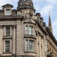
A fairly wrong clock, given that I took this at about 12:40. This used to be the Midland Bank.
Tags: Bristol Places UK onemilematt united kingdom architecture City Centre clock Corn Street old city Midland Bank
Auto-Tags: Sky Building Window Cloud Facade City House Turret Roof Medieval architecture Sash window Stately home Apartment Classical architecture Street
Text Recognition Tags: Teatestens ***************/ HARBOUR HOTE bucet Teatestens *************** / HARBOUR HOTE bucet
Nipping Up the Zig Zag to the Shops
19 Aug 2023
It's been a long while since I did one of these walks.
I'm thinking of finishing up the project by walking one or two last bits of road, thus being able to declare with all honesty that I've done my best to walk every public road within my mile (and quite a few alleyways besides.) As a prelude, and just because I felt like it, I decided to drag out the camera and GPS on this little wander to the local shops.
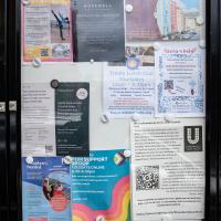
More notices, including a couple of newcomers to the local businesses: Hopewell, an estate agency, has opened up just down Hopechapel Hill in the place of The Landmark Practice (an environmental consultancy firm that seem to have moved out to Long Ashton) and HappyBack, who I'd noticed appearing down on the Hotwell Road a month or two ago.
Tags: Bristol Places UK onemilematt united kingdom Clifton Village Hotwells Clifton
Auto-Tags: Poster Font Gas Signage Advertising Facade Display board Billboard Town City Machine Transport
Text Recognition Tags: SAVE JACOBS WELLS your We W ty WS Na à Order w a gratyf Lauan ya wld worldcat HERE THE PETI Cale wwwwww CHBUEC C www d Dabe 17 TANTO F www. 0-100 Your journey is our journey and we are here to help you every step of the way Wend fpwith vir Ourica apteert papper mating nything t neces or Sc ng vs Shack and petere p FM 2 yan unteers Needed 0/0 70-23 DAN HappyBack Find Ho D Highly experienced Physiotherapy. Osteopathy and H® Massage specialists, helping you to get your happy back! W Lifeskills Lifeskills Learning for Living Py Acad Marg back. people to join our amazing toomer volunteers Oxime ww We are your new neighbours! pelare a prsity independent state aguny tinging together every best o ort, medium Alongtam ss and mes for sale across the city ravis A NEW Ma # HOPEWELL Come and say hello at our new offic orated at Hope Chcel House Hone Chapel Hill BSB IND 0117 911 8663 CERED ww are acest (10-only) og for new SANT FREE PEER SUPPORT GROUP TUESDAYS ONLINE 6.30-8.30pm 24ury Facilitated by LGBTQIA people Safe, nonjudgemental, confidential space to discuss mental wellbeing with other LGSTOLA+people Trinity Lunch Club Thursdays 10am-3:30pm Morning Coffee Armchair Excises 3 Course Home Cooked Lunch CET ARTIN Quiz Activities Tea & Biscuits For more information Call 07458 300 210 or email tes@holytrinityhotwells.org Holy Trinity Church serving the communities of Hotwells, Cliftonwood, Saike Island, Harboursie holytrinityhotwells.org Alexander May Having a baby? 42- AU You and your birth partner weinstela Calm Births Hypnobirthing FREE TASTER SESSION, online with Dolanan Monday th September OXO 7.30pm P By placeb www.dealbws.com We are devastated by the fire at the Underfall Yard. fre The fee has destroyed the heart of the Yard where most of the boat building activity takes place and tenant's businesses and boats have. been ruined. Thankfully no one was killed and no on was injured, but a lot of people in the Underfall Yard community have been impacted our staff, our tenants, our volunteers and our neighbours on Avon Crescent and Nova Scotia Place. Our hearts are with them and we are supporting our tenants as best we can. P DARO l HIER UNDERFALL YARD TRUST The Underfall Yard Trust was formed i the 1990's to bring the Underfall Yard out of dereliction, to look after the historio buildings, to shine a light on Bristoll's engineering harbour heritage and to promote traditional marine skills. In light of the devastation at the Yard, those aims remain as relevant now as they were then, SE We absolutely are committed to rebuilding the Underfall Yard and continuing the charity's work, If you would like to support the Trust, please see our JustGiving page, scan the QR code or alternatively, there is a donation box located on the Café till. https://www.justgiving.com/theunderfallyardtrust SAVE JACOBS WELLS your We W ty WS Na à Order w a gratyf Lauan ya wld worldcat HERE THE PETI Cale wwwwww CHBUEC C www d Dabe 17 TANTO F www . 0-100 Your journey is our journey and we are here to help you every step of the way Wend fpwith vir Ourica apteert papper mating nything t neces or Sc ng vs Shack and petere p FM 2 yan unteers Needed 0/0 70-23 DAN HappyBack Find Ho D Highly experienced Physiotherapy . Osteopathy and H® Massage specialists , helping you to get your happy back ! W Lifeskills Lifeskills Learning for Living Py Acad Marg back . people to join our amazing toomer volunteers Oxime ww We are your new neighbours ! pelare a prsity independent state aguny tinging together every best o ort , medium Alongtam ss and mes for sale across the city ravis A NEW Ma # HOPEWELL Come and say hello at our new offic orated at Hope Chcel House Hone Chapel Hill BSB IND 0117 911 8663 CERED ww are acest ( 10 - only ) og for new SANT FREE PEER SUPPORT GROUP TUESDAYS ONLINE 6.30-8.30pm 24ury Facilitated by LGBTQIA people Safe , nonjudgemental , confidential space to discuss mental wellbeing with other LGSTOLA + people Trinity Lunch Club Thursdays 10 am-3:30pm Morning Coffee Armchair Excises 3 Course Home Cooked Lunch CET ARTIN Quiz Activities Tea & Biscuits For more information Call 07458 300 210 or email tes@holytrinityhotwells.org Holy Trinity Church serving the communities of Hotwells , Cliftonwood , Saike Island , Harboursie holytrinityhotwells.org Alexander May Having a baby ? 42 AU You and your birth partner weinstela Calm Births Hypnobirthing FREE TASTER SESSION , online with Dolanan Monday th September OXO 7.30pm P By placeb www.dealbws.com We are devastated by the fire at the Underfall Yard . fre The fee has destroyed the heart of the Yard where most of the boat building activity takes place and tenant's businesses and boats have . been ruined . Thankfully no one was killed and no on was injured , but a lot of people in the Underfall Yard community have been impacted our staff , our tenants , our volunteers and our neighbours on Avon Crescent and Nova Scotia Place . Our hearts are with them and we are supporting our tenants as best we can . P DARO l HIER UNDERFALL YARD TRUST The Underfall Yard Trust was formed i the 1990's to bring the Underfall Yard out of dereliction , to look after the historio buildings , to shine a light on Bristoll's engineering harbour heritage and to promote traditional marine skills . In light of the devastation at the Yard , those aims remain as relevant now as they were then , SE We absolutely are committed to rebuilding the Underfall Yard and continuing the charity's work , If you would like to support the Trust , please see our JustGiving page , scan the QR code or alternatively , there is a donation box located on the Café till . https://www.justgiving.com/theunderfallyardtrust
Nothing New
02 Dec 2020
This may be the very first time I've gone for a One Mile Matt wander and not actually gone down any new roads, trod any new steps. I just wanted a coffee, frankly, so I went the same old way to Imagine That in the marina and back again.
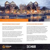
This is the current plan to replace the caravan park
Tags: Bristol Places UK onemilematt united kingdom baltic wharf
Auto-Tags: Property Light World Architecture Font Line Sky Material property Natural landscape Publication Real estate Adaptation Landmark Landscape Travel
Text Recognition Tags: BALTIC WHARFI NEW HOMES FOR BALTIC WHARF Hew the propesed deveinpmemt cend oek frem the Flating Harter WHAT IS PROPOSEO FOR BALTIC WHARF? WHY DO WE NEED MORE NEW HOMES? Goram Homes, Bristol City Council's housing company, has partnered with Hil to propose transformational plans for Baltic Whart This would provide approsimately 165 new homes, including 406 affordable. It is widety acknowledged that the curent housing crisis has led to the under provision of housing and particularly atfordable housing within Bristol. Although much is being done in the City to address the crisis, there are key issues with affordability, rough sleeping, and lack of social housing Bristol currently has over 13,000 famlies on the affordable housing register and a further 710 people in temporary accommodation. The aim is to create a vibrant destination on the Floating Harbour with homes, retail, restaurants and commercial spece, one that is well connected to local walking and cycling routes, seamiessly integrates with the historic setting and capitalises on the waterfrort setting with expansive views across the lamous Bristol townscape. Comparing house prices in Bristol to those in other Core Cities in the decade between 2008 and 2018 indicated that Bristol had the highest average housing costs of all the Core Cities in this period, and also the highest percentage Increase - over S6, compared to a UK average increase in costs of just over 32 The site is the Boltik Wharf Carian Club, The site is owned by Bristol City Counci and as part of the overarching ambition to deliver high quality homes, this site has been identified as a site capable of providing bomes for Bristal. GORAM HOMES 出Hill Goram Homes was founded in 2018 as part ol an initiative from Bristol City Counci, wich the ambition to increase the provision of nea hemes in the city and to meet affordable housing requirements without compromising on build quality Goram Homes is a subsidary of Bristol Holding Ltd, HIl is an award-winning 5 star housebuilder, creating a range of beautiful and awardwinning new homes across the south of England. They are a leading partnership developer, delivering distinctive and award-winning new homes, having been named Housebuilder of the Year, medium and large, in 2018. which is wholly owned by Bristol City Council Goram is set up to deliver mised tenure housing on a joint ventune basis and our share of profit wil feed back into the funding of council servicel BALTIC WHARFI NEW HOMES FOR BALTIC WHARF Hew the propesed deveinpmemt cend oek frem the Flating Harter WHAT IS PROPOSEO FOR BALTIC WHARF? WHY DO WE NEED MORE NEW HOMES? Goram Homes, Bristol City Council's housing company, has partnered with Hil to propose transformational plans for Baltic Whart This would provide approsimately 165 new homes, including 406 affordable. It is widety acknowledged that the curent housing crisis has led to the under provision of housing and particularly atfordable housing within Bristol. Although much is being done in the City to address the crisis, there are key issues with affordability, rough sleeping, and lack of social housing Bristol currently has over 13,000 famlies on the affordable housing register and a further 710 people in temporary accommodation. The aim is to create a vibrant destination on the Floating Harbour with homes, retail, restaurants and commercial spece, one that is well connected to local walking and cycling routes, seamiessly integrates with the historic setting and capitalises on the waterfrort setting with expansive views across the lamous Bristol townscape. Comparing house prices in Bristol to those in other Core Cities in the decade between 2008 and 2018 indicated that Bristol had the highest average housing costs of all the Core Cities in this period, and also the highest percentage Increase - over S6, compared to a UK average increase in costs of just over 32 The site is the Boltik Wharf Carian Club, The site is owned by Bristol City Counci and as part of the overarching ambition to deliver high quality homes, this site has been identified as a site capable of providing bomes for Bristal. GORAM HOMES 出 Hill Goram Homes was founded in 2018 as part ol an initiative from Bristol City Counci, wich the ambition to increase the provision of nea hemes in the city and to meet affordable housing requirements without compromising on build quality Goram Homes is a subsidary of Bristol Holding Ltd, HIl is an award-winning 5 star housebuilder, creating a range of beautiful and awardwinning new homes across the south of England. They are a leading partnership developer, delivering distinctive and award-winning new homes, having been named Housebuilder of the Year, medium and large, in 2018. which is wholly owned by Bristol City Council Goram is set up to deliver mised tenure housing on a joint ventune basis and our share of profit wil feed back into the funding of council servicel
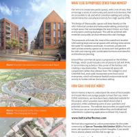
This is the current plan to replace the caravan park
Tags: Bristol Places UK onemilematt united kingdom baltic wharf
Auto-Tags: Property Architecture Font Line Urban design Real estate Landmark Screenshot Publication Facade Cloud Landscape Advertising City History
Text Recognition Tags: BALTIC WHARF WHAT ELSE IS PROPOSED OTHER THAN HOMES? Our aim is to create new public spaces, with a mix of uses, that encourage a sense of community and social inclusiveness, that are accessible to all, and which prioritise walking and cycling. social interaction and physical activity for a high quality of ife. The design of these public spaces wil draw heavily on the site's historical contet and harbournide setting, producing a unique space that acknowledges the area's history as a busy and dynamic working dockyard. This will be achieved with materials and public art that reference the site's heritage. The proposals will make the most of the waterfront location with seating steps and social spaces with striking views across the water for residents and locats. in contrast, private and semi-private amenity spaces on terraces and roof gardens will be calm and relasing with comfortable furniture and colourful and biodiverse planting. Ground floor commercial space is proposed on the harbour frontage, which could include a mix of places to eat and drink, in turn enhancing activity in this comer of the harbour and creating a new destination. The commercial space will complement rather than detract from The Cottage Inn and Underlall Yard, and could incorporate some local social enterprises, which will enhance footfal and promote social activity to further eniven the harbour setting Above: How theo cite cou lockhom Cumberlard Hoad HOW CAN I FIND OUT MORE? Goram Homes is keen to understand the views of local people and would like to encourage people to have their say. Given COMD restrictions, we have launched a dedicated website for the project, which provides more detail about what is proposed, whilst addressing some ef your questions and potential concems. The website also provides an opportunity to have your say on our plans before they are finalised and submitted in a planning application to Bristol City Councit Abover The proposals withintheir contot Belaw: The emergng site layout www.balticwharfhomes.com We have also organised an ontine presentabion for the wider community at Tpm on Thursday Bth October 2020 1o find out more, ask questions and give us their thoughts, Ifyou would like to attend, please visit this link to sign-up: www.balticwharfhomes.com/presentation If you are unable to visit either website, please give our Co Isultation team a call on 07342 039 444 (during office hours), who can book you in and make olternative amangements to get involved in the session, or provide all information in an alternative fomat appropriate for you BALTIC WHARF WHAT ELSE IS PROPOSED OTHER THAN HOMES? Our aim is to create new public spaces, with a mix of uses, that encourage a sense of community and social inclusiveness, that are accessible to all, and which prioritise walking and cycling. social interaction and physical activity for a high quality of ife. The design of these public spaces wil draw heavily on the site's historical contet and harbournide setting, producing a unique space that acknowledges the area's history as a busy and dynamic working dockyard. This will be achieved with materials and public art that reference the site's heritage. The proposals will make the most of the waterfront location with seating steps and social spaces with striking views across the water for residents and locats. in contrast, private and semi-private amenity spaces on terraces and roof gardens will be calm and relasing with comfortable furniture and colourful and biodiverse planting. Ground floor commercial space is proposed on the harbour frontage, which could include a mix of places to eat and drink, in turn enhancing activity in this comer of the harbour and creating a new destination. The commercial space will complement rather than detract from The Cottage Inn and Underlall Yard, and could incorporate some local social enterprises, which will enhance footfal and promote social activity to further eniven the harbour setting Above: How theo cite cou lockhom Cumberlard Hoad HOW CAN I FIND OUT MORE? Goram Homes is keen to understand the views of local people and would like to encourage people to have their say. Given COMD restrictions, we have launched a dedicated website for the project, which provides more detail about what is proposed, whilst addressing some ef your questions and potential concems. The website also provides an opportunity to have your say on our plans before they are finalised and submitted in a planning application to Bristol City Councit Abover The proposals withintheir contot Belaw: The emergng site layout www.balticwharfhomes.com We have also organised an ontine presentabion for the wider community at Tpm on Thursday Bth October 2020 1o find out more, ask questions and give us their thoughts, Ifyou would like to attend, please visit this link to sign-up: www.balticwharfhomes.com/presentation If you are unable to visit either website, please give our Co Isultation team a call on 07342 039 444 (during office hours), who can book you in and make olternative amangements to get involved in the session, or provide all information in an alternative fomat appropriate for you
Tags: Bristol Places UK onemilematt united kingdom Hotwells harbourside floating harbour harbour Merchant's Bridge harborside
Auto-Tags: Water Sky Cloud Building Street light Window Lake House Bridge City Dock Roof Channel Evening Canal
Text Recognition Tags:
Tags: Bristol Places UK onemilematt united kingdom harbourside baltic wharf floating harbour harbour
Auto-Tags: Water Boat Watercraft Vehicle Sky Building Lake Mode of transport Boats and boating--Equipment and supplies Body of water Transport hub Cloud Morning Dock Waterway
Text Recognition Tags:
Of Bridges and Buoys
04 Mar 2021
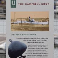
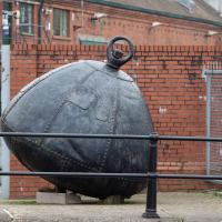
A trip to Imagine That coffee, so no fresh roads knocked off my list, but I stopped off to snap a couple of the engineering-related bits of the docks: the Campbell Buoy (used by P&A Campbell for mooring their paddle steamers) and Brunel's "other" bridge, the foot/horse swing bridge that now sits sadly disused in the shadow of the Plimsoll Bridge at Howard's Lock.
Tags: Bristol Places UK onemilematt united kingdom harbourside floating harbour harbour Spike Island engineering Buoy Campbell Buoy docks
Auto-Tags: Airship Blimp Vertebrate Aircraft Aerostat Motor vehicle Vehicle Aviation Zeppelin Air travel Font Gas Advertising Aerospace engineering Design
Text Recognition Tags: THE CAMPBELL BUOY STEAMSHIP MAINTENANCE This buoy, now resting upside down, once floated in the harbour near Underfal Yard and provided moorings for paddle steamers. Lrtil the 1980s, eounions to locations in the Brietol Channel werea tavourte hokday pastime. P&A Campbel operated a fleet of ships trom the hartbour and rented part of Udertal Yard for maintenance operations from the 1320s unti 1956. The Big Shed was used as a machine shop while the old boler room inow the Visitor Centrej and the outsicle are krown as the Knuckle wore ned as a foundry. THE CAMPBELL BUOY STEAMSHIP MAINTENANCE This buoy, now resting upside down, once floated in the harbour near Underfal Yard and provided moorings for paddle steamers. Lrtil the 1980s, eounions to locations in the Brietol Channel werea tavourte hokday pastime. P&A Campbel operated a fleet of ships trom the hartbour and rented part of Udertal Yard for maintenance operations from the 1320s unti 1956. The Big Shed was used as a machine shop while the old boler room inow the Visitor Centrej and the outsicle are krown as the Knuckle wore ned as a foundry.
Tags: Bristol Places UK onemilematt united kingdom harbourside floating harbour harbour Spike Island engineering Buoy Campbell Buoy docks
Auto-Tags: Building Window Sculpture Grey Gas Art Composite material Metal Brick Concrete Brickwork Water House Facade Sphere
Text Recognition Tags:
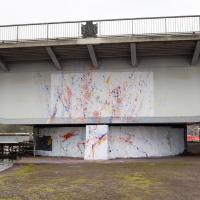
Only a week ago this looked completely different.
Tags: Bristol Places UK onemilematt united kingdom Hotwells Cumberland Basin Flyover System graffiti harbourside street art floating harbour harbour plimsoll bridge engineering docks Jackson Pollock
Auto-Tags: Daytime Architecture Paint Art Wall Line Facade Rolling Graffiti Gas Tints and shades Font Concrete Space Building material
Text Recognition Tags:
This is the pivot point for the Plimsoll Bridge. I don't think I've ever been down right here when it's swung.
Tags: Bristol Places UK onemilematt united kingdom Hotwells Cumberland Basin Flyover System graffiti harbourside street art floating harbour harbour plimsoll bridge engineering docks Jackson Pollock
Auto-Tags: Infrastructure Sky Architecture Art Wall Line Road Asphalt Girder bridge Concrete Urban area Rolling Building Composite material Bridge
Text Recognition Tags:

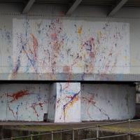
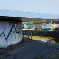
Someone seems to have installed a tribute to Jackson Pollock.
Tags: Bristol Places UK onemilematt united kingdom Hotwells Cumberland Basin Flyover System graffiti harbourside street art floating harbour harbour plimsoll bridge engineering docks Jackson Pollock
Auto-Tags: Art paint World Paint Asphalt Art Wall Rolling Graffiti Font Gas Tints and shades Facade Painting Space Symmetry
Text Recognition Tags:

Tags: Bristol Places UK onemilematt united kingdom Hotwells Cumberland Basin Flyover System graffiti harbourside street art floating harbour harbour plimsoll bridge engineering docks Jackson Pollock
Auto-Tags: Paint World Art paint Road surface Asphalt Graffiti Brick Art Line Wall Gas Tints and shades Sidewalk Door Font
Text Recognition Tags:
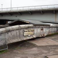
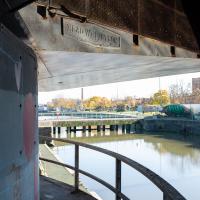
Brunel's Other Bridge ("Bob") was originally made to carry traffic over the South Entrance lock.
As part of the redesign/replacement of the North Entrance lock by Docks Engineer Thomas Howard, it was shortened and moved here, to the lock now known as Howard's Lock.
It was decommissioned in 1968 after the giant Plimsoll swing bridge that dwarfs it in the picture was put in as part of the Cumberland Road Flyover system.
A team of dedicated volunteers have been restoring it and documenting the process, and the bridge itself.
Tags: Bristol Places UK onemilematt united kingdom Hotwells Cumberland Basin Flyover System harbourside Entrance Lock floating harbour harbour plimsoll bridge engineering docks Brunel's Other Bridge Howard's Lock
Auto-Tags: Sky Asphalt Road surface Composite material Road Rolling Concrete Art Graffiti Sport venue City Concrete bridge Overpass Tar Nonbuilding structure
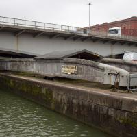
From here it's easier to see the pivot point for Brunel's Other Bridge, and the wheels at this end which would have helped it roll. It weighs about 68 tons, and was originally turned by a hand crank before being converted to hydraulic power like much of the rest of the docks equipment.
You can see an aerial photo of it in place in its "swung" position on the Brunel's Other Bridge website.
Tags: Bristol Places UK onemilematt united kingdom Hotwells Cumberland Basin Flyover System harbourside Entrance Lock floating harbour harbour plimsoll bridge engineering docks Brunel's Other Bridge Howard's Lock
Auto-Tags: Water Sky Window Building Watercourse Cloud Girder bridge Concrete bridge Composite material Lake Bridge Canal Beam bridge Channel Nonbuilding structure
Text Recognition Tags:
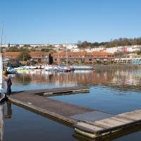
Baltic Wharf and Marina
04 Nov 2020
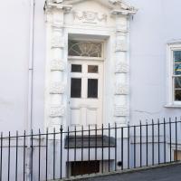
You never know what you'll find when you go for a walk in Bristol. This gorgeous Mustang was in the Marina car park. Nice. I also surprised myself by getting a good photo of The Hand (to give it its full title, Green Hand of a River God, by Vincent Woropay. Thanks, @mfimage!)
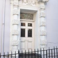
Someone told me, years ago, that someone had got planning permission to convert this building into flats, but had been refused planning permission to remove this handsome historic door. I have no idea how true that story is, but it seems plausible. The building is Granby House, on the corner of Hope Chapel Hill and Granby Hill.
Tags: Bristol Places UK onemilematt united kingdom Hotwells harbourside floating harbour harbour
Auto-Tags: Window Building Blue Fence Fixture Door Wood Material property Facade Home door Symmetry Composite material Metal Arch Home fencing
Text Recognition Tags:
Tags: Bristol Places UK onemilematt united kingdom Hotwells Cumberland Basin Flyover System harbourside floating harbour harbour plimsoll bridge
Auto-Tags: Plant Sky Asphalt Road surface Art Paint Tints and shades Rolling Road Tree Shade Graffiti City Facade Concrete
Text Recognition Tags:
I can't recall walking around this side of the Plimsoll Bridge pivot before, for no other reason than habit, I think.
Tags: Bristol Places UK onemilematt united kingdom Hotwells Cumberland Basin Flyover System harbourside floating harbour harbour plimsoll bridge
Auto-Tags: Water Sky Shade Body of water Tree Waterway Morning Plant Tints and shades Bridge City Reflection Winter Girder bridge Symmetry
Text Recognition Tags: HEAD WIGEVEON HEAD WIGEVEON
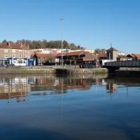
Nice colours at Cumberland Basin today
Tags: Bristol Places UK onemilematt united kingdom Hotwells harbourside Cumberland Basin floating harbour harbour
Auto-Tags: Water Sky Water resources Street light Building Lake House Bank Window Dock City Canal Harbor Winter Suburb
Text Recognition Tags:
Tags: Bristol Places UK onemilematt united kingdom harbourside floating harbour harbour
Auto-Tags: Window Building Road surface Asphalt Public space Sidewalk Brick Gas Road City Fixture Facade Brickwork Electric blue Motor vehicle
Text Recognition Tags: A BLOCK BRISTOL MARITIME A BLOCK BRISTOL MARITIME
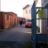
I considered going down to the end of this engineering bit behind the Harbourmaster's office, but I know it's a dead end and I don't think the woman walking her dog did. It felt like it would be a bit weird to follow someone down a dead end, so maybe I'll go back another day. On the other hand, I don't think it counts as a public road..
Tags: Bristol Places UK onemilematt united kingdom harbourside floating harbour harbour
Auto-Tags: Car Building Window Vehicle Sky Plant Road surface Wood Brickwork Asphalt House Vehicle registration plate Brick Automotive lighting Street light
Text Recognition Tags: DANGER NO ACCESS DANGER NO ACCESS
Tags: Bristol Places UK onemilematt united kingdom harbourside floating harbour harbour
Auto-Tags: Water Sky Water resources Azure Vehicle Lake Tree Dock Morning Watercraft Waterway Calm Wood Boat Leisure
Text Recognition Tags:
Tags: Bristol Places UK onemilematt united kingdom harbourside floating harbour harbour
Auto-Tags: Water Sky Water resources Boat Watercraft Azure Transport hub Building Vehicle Boats and boating--Equipment and supplies Dock Lake City Waterway Harbor
Text Recognition Tags:
Tags: Bristol Places UK onemilematt united kingdom harbourside floating harbour harbour
Auto-Tags: Water Sky Boat Watercraft Vehicle Transport hub Lake Dock Tree Boats and boating--Equipment and supplies Leisure Calm Harbor City Water transportation
Text Recognition Tags:
Quick Coffee
19 Nov 2020
A sunny day, and though I should have probably headed for less well-travelled territory I just headed over to the Marina to grab a flat white from Imagine That's horsebox café.
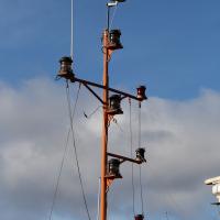
I'm not entirely sure why this little pole seems to need so many red lights, or what the tiny circular thing that looks like a specialist antenna is at the top (there's clearly a few other antennas, and I also have no idea what they're for.) Just part of the varied harbour infrastructure I walk past every day and would probably be fascinated to hear about if I knew who to ask...
Tags: Bristol Places UK onemilematt united kingdom harbourside floating harbour harbour Spike Island
Auto-Tags: Sky Cloud Electricity Pole Electronic device Public utility Electrical supply Wire Overhead power line Tower Cable Antenna Tree Street light Gas
Text Recognition Tags:
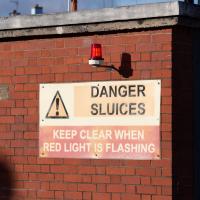
What, should I keep clear from this side? I'm assuming that this doesn't actually affect anything on dry land...
Tags: Bristol Places UK onemilematt united kingdom harbourside floating harbour harbour Spike Island
Auto-Tags: Window Sky Building Brick Brickwork Fixture Architecture Building material Font Line Wall Neighbourhood Red Facade Real estate
Text Recognition Tags: DANGER SLUICES KEEP CLEAR WHEN RED LIGHT IS FLASHING DANGER SLUICES KEEP CLEAR WHEN RED LIGHT IS FLASHING
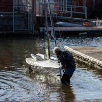
Reflective little boat.
Tags: Bristol Places UK onemilematt united kingdom harbourside floating harbour harbour Spike Island
Auto-Tags: Water Vehicle Building Boats and boating--Equipment and supplies Body of water Lake Wood Watercraft Dock Boat Recreation Tree Leisure Channel Reflection
Text Recognition Tags:
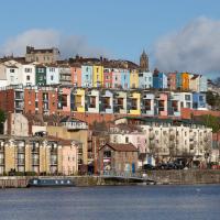
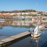
Tags: Bristol Places UK onemilematt united kingdom cliftonwood harbourside floating harbour harbour Spike Island colourful houses
Auto-Tags: Water Cloud Sky Building Window Azure House Lake Neighbourhood Residential area City Facade Tree Waterway Cityscape
Text Recognition Tags:
Tags: Bristol Places UK onemilematt united kingdom harbourside floating harbour harbour Spike Island
Auto-Tags: Water Sky Building Window Cloud Boat Watercraft House Body of water Tree Lake Neighbourhood Vehicle City Waterway
Text Recognition Tags:
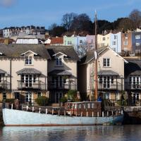
Tags: Bristol Places UK onemilematt united kingdom harbourside floating harbour harbour Spike Island
Auto-Tags: Water Daytime Window Building Lake Wood Urban design Wall Public space Morning Residential area City Landmark Facade Waterway
Text Recognition Tags:

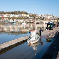
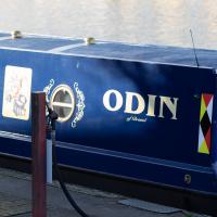
Now, my first thought was Thor, but the name of the boat might beg to differ.
Tags: Bristol Places UK onemilematt united kingdom harbourside floating harbour harbour Spike Island
Auto-Tags: Rectangle Blue Font Material property Emblem Gas Electric blue Symbol Metal Art Fashion accessory Crest Jewellery Badge Logo
Text Recognition Tags:
Tags: Bristol Places UK onemilematt united kingdom harbourside floating harbour harbour Spike Island
Auto-Tags: Train Motor vehicle Rolling stock Vehicle Rolling Railway Track Automotive exterior Railroad car Locomotive Gas Automotive lighting Public transport Automotive wheel system Electric blue
Text Recognition Tags: O9 ODIN riatal O9 ODIN riatal
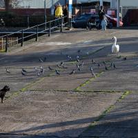
That uneasy moment before it all kicks off
Tags: Bristol Places UK onemilematt united kingdom harbourside floating harbour harbour Spike Island marina
Auto-Tags: Bird Beak Building Plant Road surface Asphalt Grass Tree Urban design Sidewalk City Water bird Recreation Waterfowl Leisure
Text Recognition Tags:
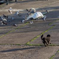
There we go.
Tags: Bristol Places UK onemilematt united kingdom harbourside floating harbour harbour Spike Island marina
Auto-Tags: Bird Vertebrate Beak Grey Grass Stock dove Asphalt Seabird Road surface Tail Terrestrial animal Lari Rock dove Wildlife Water bird
Text Recognition Tags: