Tagged: bridge
Nowhere New
10 Dec 2020
I didn't have any time to find a new place to go today, so I'm treading old ground here. I did buy a tub of duck food from Amazon last week and today I remembered to take a little bagful of it with me on my trip to Imagine That coffee, and spent a few minutes feeding the marina slipway ducks on the way back. This is a Bristol tradition I've seen other people doing many times, but never tried myself. It was quite genteel until the seagulls cottoned on, then it became something of a brawl.
Coffee Run
31 Mar 2021
Not a literal run, but I didn't hang about, as I had a job interview to get to (I was an interviewer, not the interviewee, but you still have to be there on time...) Along the way to pick up a lunchtime coffee I mostly seemed to take photos of the high tide, though I also came across a bit of outreach work for small spiny mammals...
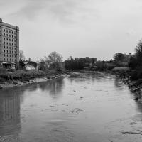
I'm in the habit of going over to the Tobacco Factory Market on a Sunday. I think I've walked all the routes around that way, but as a Plimsoll Bridge swing let me cross the road to the far side of Brunel Way on my return journey and I took a couple of photos of the brownfield development at the old Ashton Gate Depot site I thought I'd call it a Wander and pop some photos up.
I've recently been playing the computer game Life Is Strange, and it's inspired me to get a bit more snappy. The heroine is a photography student, and part of the game is to go around snapping artistic pics with her Polaroid camera. I don't have a polaroid, but the game did inspire me to stick the simple 50mm prime lens on the camera and to trust my instincts on things to snap. This was probably the best result of the day.
But, of course, no Metrobuses, as they don't do anything as useful as running on a Sunday.
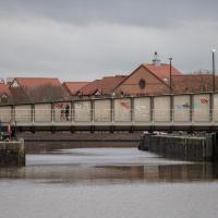
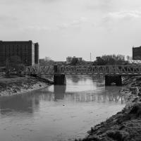
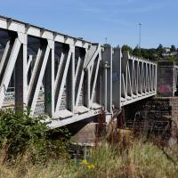
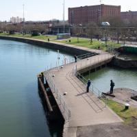
They really couldn't make it much clearer that drivers are meant to nip off down the off ramp up ahead and take Junction Swing Bridge instead. But if anyone ever does I've not seen it. I don't think I've ever been caught in the queue here as a driver, but then I don't do much driving.
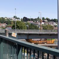
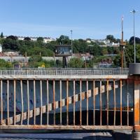
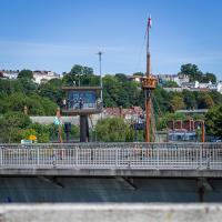
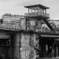
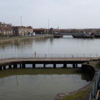
One of the things I like about Bristol is the strange contrasts. Here we have two crow's nests. The first is the Cumberland Basin Flyover System's Plimsoll Bridge control room, used to give the swing bridge operator a good view of the whole area surrounding the bridge. The second is the reason for the swing, the crow's nest on the tall mast of the replica of John Cabot's Matthew, as it passes through into Entrance Lock.
Up for the flu jab
21 Nov 2020
A trip up the hill to get my winter flu jab. I'm not sure I really needed it this year, what with avoiding Covid—I haven't had so much as a sniffle in more than a year—but seeing as they offered... Instead of the doctor's surgery on Pembroke Road, they'd taken over Christ Church, presumably to give more room and ventilation for the necessary social distancing at the moment. As usual, it was their typically efficient operation, and I was in and out in about three minutes.
On the way there and back I snapped as much as I could, but I wanted to be home in time for the first online Times Crossword Championship. As it turned out, I needn't have bothered, as the technology at the Times couldn't keep up with the demand from competitors, and their system just collapsed under the weight of page-views. They tried again the day after, and it collapsed just as badly. Maybe next year...
This wander is split into two parts, as I turned my tech off to go into Christ Church for my jab. The walk home can be found over here.
I got interested in Bristol's medieval water supplies after poking around near Jacobs Wells Road and Brandon Hill. It was during that research I found out about a pipe that's still there today, and, as far as I know, still actually functioning, that was originally commissioned by Carmelite monks in the 13th century. They wanted a supply of spring water from Brandon Hill to their priory on the site of what's now the Bristol Beacon—Colston Hall, as-was. It was created around 1267, and later, in 1376, extended generously with an extra "feather" pipe to St John's On The Wall, giving the pipework its modern name of "St John's Conduit".
St John's on the Wall is still there, guarding the remaining city gate at the end of Broad Street, and the outlet tap area was recently refurbished. It doesn't run continuously now, like it did when I first moved to Bristol and worked at the end of Broad Street, in the Everard Building, but I believe the pipe still functions. One day I'd like to see that tap running...
There are a few links on the web about the pipe, but by far the best thing to do is to watch this short and fascinating 1970s TV documentary called The Hidden Source, which has some footage of the actual pipe and also lots of fantastic general footage of Bristol in the seventies.
On my walk today I was actually just going to the building society in town, but I decided to trace some of the route of the Carmelite pipe, including visiting streets it runs under, like Park Street, Christmas Street, and, of course, Pipe Lane. I also went a bit out of my way to check out St James' Priory, the oldest building in Bristol, seeing as it was just around the corner from the building society.
There are far too many pictures from this walk, and my feet are now quite sore, because it was a long one. But I enjoyed it.
I'm reminded of what Gandhi said about Western Civilisation.
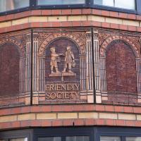
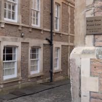
Former offices of the National Deposit Friendly Society.
Long Bemmie Wander with Lisa
11 Apr 2021
My friend Lisa joined me again, this time for a long wander through "Bemmie". In fact, I tweeted recently using "Bedmo" as my abbreviation for Bedminster, and apparently there's something of a culture war going on. From what I can glean, the longer-term residents call it "Bemmie" and consider "Bedmo" a name made up by hipster gentrifiers.
I had no idea, but then I didn't grow up around here, and I don't live in Bedminster, and I'm not a hipster. I'm not sure I've ever gentrified anywhere, either; Hotwells was already quite gentrified by the time I arrived. I probably just lowered the tone a bit.
Anyway. Lisa and I entered Bemmie by the traditional toll gate (though actually you'd only have paid if you were coming from the Long Ashton direction, not merely nipping across from Hotwells) and then almost literally combed the streets to knock several new roads off my list of targets. Along the way we saw lots of street art, as you'd expect, and admired the area's panoply of gorgeous knockers.
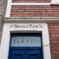
I love the way the painted-in letters really stand out, and the bold transom sign is the icing on the cake here.
Better Look at an Extension
14 Apr 2021
Apart from a lovely coffee and a slice of Victoria sponge from Twelve, there weren't any new sights on this little lunchtime jaunt except for a slightly better look at the long raised extension at the back of the St Vincent's Rocks Hotel, where I at least got to see the arches it's raised up on. I also got a fair bit of exercise by walking up the Zig Zag to get there, and saw far more people out than I have in months, what with the lockdown having just been significantly lifted. As I walked past The Mall pub they were turning people away from their already-full garden, and the (outdoor) cafe tables were pretty full up.
I mostly went out to hang out with my friends Sarah and Vik in Bedminster, but along the way I thought I'd take a closer look at something a little nearer home: the last crossing point of the Rownham Ferry.
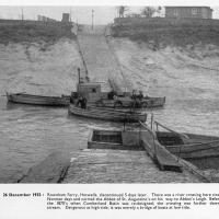
And here's the picture that inspired this little local visit today. A week or so back I was browsing the boxes of books at Rachel's and Michael's Antiques on Princess VIctoria Street, and flipping through their collection of Reece Winstone books. Winstone's famous Bristol As It Was series are an amazing documentary source created by a man who loved both photography and Bristol and effectively became Bristol's foremost documentary photographer for decades. A lot more of Bristol's history is visible today because of him.
In the Bristol As It Was 1939 - 1914 book I saw this picture of the Rownham Ferry. Unfortunately the book was a first edition and priced at £20, so I ordered a cheaper edition from an independent dealer in Stockport when I got home! (Let's consider that as me leaving the rare first edition for the true connoisseurs, rather than just being cheap.)
Here we see the ferry just five days before its closure on the last day of 1932. Looking closely, it seems to be perhaps operating as a reaction ferry, with the boat tethered to a static line across the river, and the ferryman using the rudder to turn the boat and use the power of the flowing water to shuttle the boat from side to side. Clever!
Photo © Reece Winstone Archive. (I recommend buying the books if you like old photos of Bristol. They're amazing!)
That reminds me; I must re-read Iain M Banks's Use of Weapons again. In the novel he used the name Size Isn't Everything for one of the Culture's General System Vehicles, a spacecraft approximately 80km long... In the Culture, spacecraft are sentient and Culture ships choose their own names, often ironically.
He we have something of the opposite size of craft.
I've been pretty awful at reading so far this year, apparently averaging about one book per month. That's a far cry from 2019, say, where I got through 41 books in the year. Today's wander was prompted by my rubbish reading, as I needed to go hand back some books to the library, because I'd managed to renew them so many times that I hit the limit on renewals. Oops. Several of them were still unread.
So, off to the Central Library for me, tail between my legs. On the way there I did my best to recreate a historical photo of Dowry Square; while I was in the area I walked under the adjacent Norman arch and poked around behind the Cathedral, and I also had a little diversion to the city centre and came back along the south side of the river, hitting some trouble with the lock gates as I finally crossed the harbour back towards home.
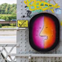
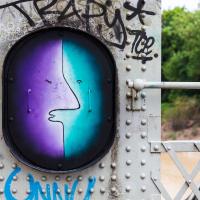
I'd seen from maybepaints feed that they'd popped a couple of new faces up on the Ashton Avenue bridge. Here's the first...
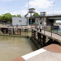
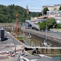
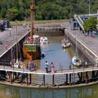
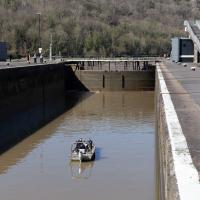
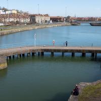
While I was taking the last few photos I'd been hearing the two-tone alarm signal of a bridge swing, so I knew something would be going on at the lock when I got here. This time, though, I got more than I bargained for.
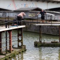
I was coming up to cross at these lock gates like normal when I saw that the lock keeper operating the hydraulics was having some difficulties. Sure enough, after a few attempts at closing the gates, it became apparent that they just weren't having any of it. They were getting this close to closing and then jamming.
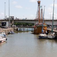
As you can see, there were quite a lot of boats waiting to leave Bristol for a jaunt down the river, most notably the Matthew, and Bristol Packet's Bagheera.
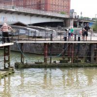
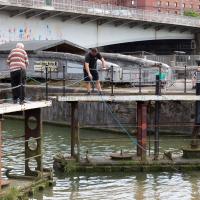
I was expecting them to pull a shopping trolley out at any moment. They weren't managing to snag anything, though.
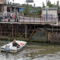
While I was tempted to hang around to see if they eventually pulled anything out of the way, the heat of the day was beating down pretty hard by this point and I didn't want to risk sunburn, so I headed home. As did all the boats in the lock, who returned back into Cumberland Basin and presumably eventually back to the city, refunding/rebooking their passengers.
I found out that my decision to leave had been a good one two days later, on Tuesday evening, when I happened to be on my walking commute home during another locking out, this time with the lock gates working. I asked the lock keeper about the problem, and apparently they'd tried hooking out whatever was fouling the gate for quite some time on Sunday, but eventually gave up and sent divers in on Monday, who pulled out a large section of chain-link fence that was fouling the south lock gate and got everything working again.
Since setting up a search for Hotwells on eBay I've mostly managed to restrain myself from buying much (or in one case, was outbid, luckily for my finances.) However, I couldn't resist a 1902 flyer for a singalong at the Terrett Memorial Hall, which would have stood five minutes' walk from my flat, overlooking Howard's Lock.
I've found out a fair bit about this non-denominational seaman's mission, including tracking down both a Loxton drawing and an aerial photo of it. The main thing that's eluded me, ironically enough, is finding out who Terrett was, so as a Memorial Hall it didn't do a very good job 😀.
EDIT: Ah! Did a little more digging and found that the Bristol Archives has a Bristol Dock Company document on file called "William Terrett, Esq.; corresp. etc. re proposed erection of a Mission Hall at Cumberland Basin, 1892", so that might be worth a look once the Archives are properly open again. Given that:
Sarah Terrett died suddenly on 25 November 1889, aged 53, after speaking at a meeting of the White Ribbon Army, the temperance organization she had founded in 1878. Following her death many people sent letters of sympathy to her bereaved husband, William. One of these, from the Rev. W. F. James, a minister of the Bible Christians, makes for especially interesting reading. The Bible Christian denomination, to which Sarah and William belonged, was one of the smaller Methodist connexions, and had its heartland in rural Devon, the area where she had grown up. James recalled the hospitality he enjoyed when visiting the Terretts’ home, Church House, in Bedminster, south Bristol...
...I wonder if William Terrett built the hall in memory of his late wife. They were clearly just the kind of temperance movement people who would've founded a seaman's mission to get people together to have a nice non-alcoholic singsong rather than a night out on the tiles.
Anyway. This walk to grab a coffee from Hopper Coffee in Greville Smyth Park was mostly an excuse to post the leaflet, a few other things I found related to it, and some pictures of how the site looks now. I would suggest that the present day is not an improvement.
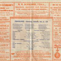
I find the adverts fascinating. My first optician in Bristol was Dunscombe's on St Augustine's Parade, so they were there a long time. They've closed now (or at least moved) but were still there as recently as 2008, I think. Interesting to see gas lighting systems being advertised, too!
Complete with a fisherman. Quite at the moment, but as a sport it does at least already have a reputation for social distancing.
Which sounds imposing, but apparently it wasn't that secure, at least as far as a place to store the golden regalia of Bristol's mayor and mayoress goes, anyway. Oops.