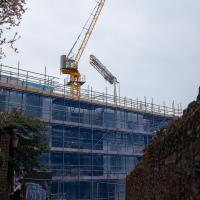
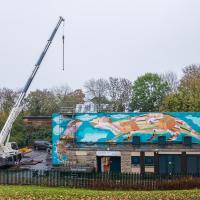
Tagged: crane
Greville Smyth
28 Oct 2020
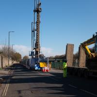
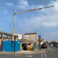
Popped out for a coffee in Greville Smyth park, and got a view of the Andy Council work on the side of the Ashton Avenue sewage pumping station on the way back.
A Trip to the Library
08 Jun 2021
I had to return a book to the library—Ellic Howe's Magicians of the Golden Dawn, very interesting, thanks for asking—so I decided to pick the Central Library as my drop-off point and walk down a segment of Deanery Road that I've surprisingly overlooked so far. In any normal time I'd have been walking to work that way quite often, or heading through at the weekend on the way to do some shopping in the city centre, or for a coffee at St Nick's, but those excursions have been quite thin on the ground for the last year or so, for obvious reasons.
I've never been inside a single building on Deanery Road itself; the Library is technically on College Green and the rest is mostly student accommodation or Bristol College buildings, by the looks of things. It's a fairly mediocre street, used merely to get to other places. (St George's Road, which merges into it, at least has the distinction of several good shops verging from the practical and long-lived car radio fitters to the excellent little Dreadnought Books, sadly currently closed for refurbishment...)
After dropping off my book I came home via the harbourside, the better to enjoy the nice sunny blue skies of the day.
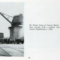
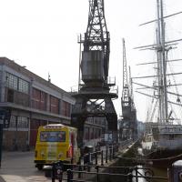
Picture from Bygone Bristol: Hotwells and the City Docks, by Brian Lewis, and Janet and Derek Fisher.
Morning Mist
05 Nov 2020
I spotted the fog and decided to go for a morning walk rather than a lunchtime walk today. It was cold on the Portway, but it was worth it. Most of my One Mile Matt photos are "record shots", but it's nice to get the chance to do something a bit more artistic.
Very Local
06 Nov 2020
It's surprisingly easy to overlook the giant Wesleyan Grenville Chapel—now converted into flats—if you've lived here a while. Other sights that seem to slip from my memory include the modest Ashton Avenue, a tidy terrace of little houses on a road that presumably gave its name to the Ashton Avenue bridge.
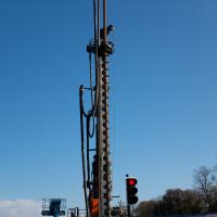
I keep on hoping this will be broken down so I can make a terrible "that doesn't auger well" joke, but so far I've been disappointed.
Cliftonwood and Clifton Village Lunchtime Stroll
14 Dec 2020
The lunchtime walk has been feeling a bit of a chore lately, especially as I only have an hour and have to keep a mental watch out for my "bingo" point or risk being late back. Today I went for a deliberately brief local walk and got home in time to have lunch on my sofa rather than while I was back at work.
It's interesting filling in the gaps in my Clifton Village knowledge, especially starting to "see" the bits I can't see, the negative spaces. The size of both Fosseway Court and the Bishop's House gardens (check out the latter on Google Maps for an idea) are both something I've noticed by just getting to know the areas around them. I may also have to walk into the driveway of the very well-hidden Nuffield hospital to get an idea of how big it is.
None of those are anything compared to the trick of hiding the gargantuan public school that is Queen Elizabeth's Hospital so well that I keep on forgetting it's there, until a glimpse of it from somewhere like Lower Clifton Hill reminds me about it, of course...
In Between
06 Feb 2021
A lovely walk in the early spring sunshine with my friend Lisa. We headed directly for Jacobs Wells Road, to start off around the scene of one of our earlier walks, but this time took in Jacobs Wells from QEH upward, stopping to snap some photos of a Bear With Me, some interesting areas between Park Street and Brandon Hill including a peculiarly quiet enclave with a ruined old build I'd never found before, then crossed the Centre to grab take-away pies from Pieminister (I had the Heidi Pie) and head back to my place down the harbourside.
Harbour Circumnavigation
01 Mar 2021
Normally I don't have enough time in my lunch hour to get all the way around the harbourside. This is a shame, as Wapping Wharf is a great place to get coffee and a snack, but it's pretty much diametrically (perimetrically?) opposite me on the harbour. Today I had the day off, so I decided to go and knock off a few streets around Anchor Road that I'd not covered, as well as visiting the site of the Read Dispensary (well, one of them) and dropping into Mokoko for one of their astounding almond croissants. From there I came back along the south side, checking out the views from as much of the Chocolate Path as you can venture down at the moment, and swapping from Cumberland Road to Coronation Road at Vauxhall Bridge.
There's a lot of meh photos on this walk—my chief output from this project could be politely described as "record shots"—but a few turned out well, especially those of Vauxhall Bridge from the Chocolate Path, which reminded me how much of a loss the current closure of the Chocolate Path is to walkers and cyclists in Bristol.
Of Bridges and Buoys
04 Mar 2021
A trip to Imagine That coffee, so no fresh roads knocked off my list, but I stopped off to snap a couple of the engineering-related bits of the docks: the Campbell Buoy (used by P&A Campbell for mooring their paddle steamers) and Brunel's "other" bridge, the foot/horse swing bridge that now sits sadly disused in the shadow of the Plimsoll Bridge at Howard's Lock.
Leigh Woods Walk
14 Mar 2021
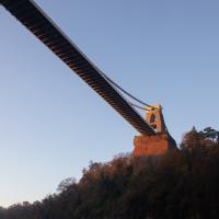
An enormous walk today, or at least it felt enormous. My feet are sore, anyway. I started off recreating a couple of local historical photos in Hotwells, but then headed for my traditional walk along the towpath in the Avon Gorge to the far extreme of Leigh Woods, up and through the woods to the height of the Suspension Bridge, finally crossing into Clifton Village for a well-deserved vanilla latte.
I say "traditional" because this used to be a very regular route for me, first walking, years and years ago, and later jogging—this route combined with a circuit of the Downs on the other side used to be my way of making sure I was fit to do a half-marathon (I did six of them in total, between 2010 and 2014).
I miss the routine of this walk, even though it's a long way and it used to pretty much wipe me out when I did it—I'd come back home and collapse and do very little for the rest of the day. But perhaps that's what Sundays are for, and I should try to remember that.
Doing this walk regularly was quite a meditative experience. Not so much of that today, but once I got to the further extreme of the towpath, where the roar of the Portway traffic on the other side of the river dwindles and I turned into Leigh Woods to climb ever closer to birdsong and further from rushing cars, I did seem to recapture a little of the feeling of previous walks. (I would say my mind cleared, but I was mentally singing along to Life Without Buildings' The Leanover for most of the wander. There are worse songs to have stuck in one's head, though; it's a great track...)
Anyway. Apparently the walk made me more likely to ramble in words, too. I'll stop now :)
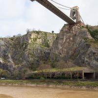
The roofed area below the Suspension Bridge is called The Gallery; it's there to prevent rocks from the particularly friable cliff face below the bridge from falling onto the Portway. It's also the rough former location of the Hotwells railway station on the Port Railway and Pier, which I explore in more details on a later wander.
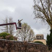
I wasn't going to take a very long walk on this nice spring evening; it just happened. I was going to knock off a path or two on Brandon Hill, home over centuries to hermits and windmills, cannons and Chartists, and then just wander home, stopping only to fill up my milk bottle at the vending machine in the Pump House car park.
However, when I heard a distant gas burner I stayed on the hill long enough to see if I could get a decent photo of both the hot air balloon drifting over with Cabot Tower in the same frame (spoiler: I couldn't. And only having the fixed-focal-length Fuji with me didn't help) and then, on the way home, bumped into my "support bubble", Sarah and Vik, and extended my walk even further do creep carefully down the slipway next to the old paddle steamer landing stage and get some photos from its furthest extreme during a very low tide...