Tagged: city
Coffee, Coronation and Clift House Road
28 May 2021
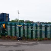
Another dash to Greville Smyth Park for a coffee from Rich at Hopper, but at least this time I managed to divert a bit and knock off a small section of Cumberland Road I'd managed to miss on previous excursions. Along the way I muse on a strange residence in between a warehouse and a tannery, and wonder if the Mayor might be deliberately letting the Cumberland Road Flyover area go to seed...
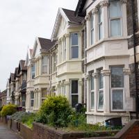
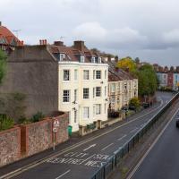
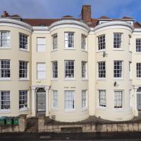
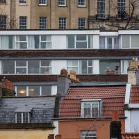
This is the bit of Coronation Road I came to wander down specifically, one of the little bits of road I'd missed on previous walks. It features the same nice Victorian terraces as much of the rest of Bedminster, including individual house names. I imagine the constant traffic reduces the appeal of this stretch, though.
A Constitutional to Burwalls and Back
21 Dec 2021
The recent lack of posts here is mostly due to my feeling very run down following having a couple of wisdom teeth extracted. Having had an emergency appointment yesterday1, hopefully I'll be on the mend now, though it does mean I'm on the kind of antibiotics where you can't touch alcohol for the whole of the Christmas period. I have tried to keep myself a little distracted from the pain by working on the nuts and bolts of this website—you should notice that the front page loads rather faster now than it used to, and that there's a shiny new statistics page that I'll probably be continuing to work on. Oh, and you should find that the tags below the photos are now clickable and will take you to a page of all other wanders that have photos with the same tag.
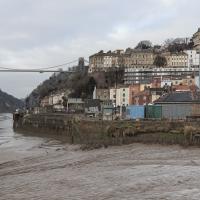
Today I felt like I needed to drag myself out of the house, but I didn't want to go too far, and I needed to get to the Post Office up in Clifton Village to post a Christmas card (spoiler for my parents: it's going to be late. Sorry.) As luck would have it, idly looking at the map I spotted that I'd missed off a section of Burwalls Road in the past, and that's basically one of the long-ways-round to Clifton Village, crossing the river to Rownham and walking up the hill on the Somerset side before coming back across the Suspension Bridge.
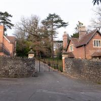
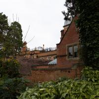
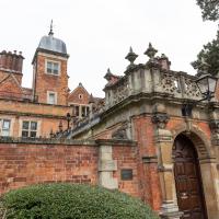
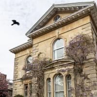
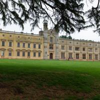
As I was heading for Burwalls Road I decided to make Burwalls itself the focal point of the walk, but unfortunately the mansion grounds are private and the place is hard to snap. Still, at least it gave me a destination. Burwalls was the mansion built by Bristol press magnate Joseph Leech, who I've mentioned before after buying a vintage book he wrote on a previous wander. There's a good article about the house on House and Heritage which has some photos from angles I couldn't ever get to. (Well, maybe with a drone, but it seems like the kind of area where they may be kitted out for clay pigeon shooting, so I probably wouldn't risk it.)
1 My dentist admitted that she probably needed to keep her internal monologue a bit more internal after we started the appointment with her staring into my mouth and immediately saying, "oh, *that's* weird." These are words one doesn't want to hear from a medical professional.
Technically that's still actually the Hotwell Road down there, and it doesn't become the Portway until the Bridge Valley Road junction, but I needed the alliteration, okay?
This is the kind of photograph that I really like, but is harder to find appreciation for these days—the Panavision aspect ratio I've chosen, 2.35:1, doesn't play nicely with today's standard media consumption device of a mobile phone held in portrait orientation. Maybe one day we'll all be using the internet through VR headsets and landscape orentation will make a comeback.
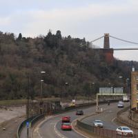
As my plan was to knock off the remaining section of Burwalls Road, my first photo is the small segment of Burwalls itself that you can see from near my house. Burwalls is the mansion on the hilltop, peeping out about halfway from the left edge of the photo and the Suspension Bridge.
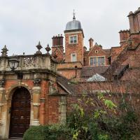
The manor was originally built by Joseph Leech, a fascinating man who was owner of the Bristol Times. Among other fun things, he used to be the "Bristol Church-goer", publishing an anonymous and apparently quite funny column as a "mystery shopper"-style reviewer of church services.
There's a bit more about him on my blog, prompted by my buying a lovely old book by him in a secondhand shop on a previous wander.
Most every time I cross the bridge, I remember one of the first times I walked over it, back in the late 1990s or early 2000s, when some wag—possibly even Banksy, who knows?—had painted a sign on the footway about here: a rectangle of yellow caution stripes containing the words "WARNING. CONCEALED TRAPDOORS IN OPERATION".
Nipping Up the Zig Zag to the Shops
19 Aug 2023
It's been a long while since I did one of these walks.
I'm thinking of finishing up the project by walking one or two last bits of road, thus being able to declare with all honesty that I've done my best to walk every public road within my mile (and quite a few alleyways besides.) As a prelude, and just because I felt like it, I decided to drag out the camera and GPS on this little wander to the local shops.
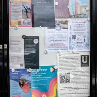
More notices, including a couple of newcomers to the local businesses: Hopewell, an estate agency, has opened up just down Hopechapel Hill in the place of The Landmark Practice (an environmental consultancy firm that seem to have moved out to Long Ashton) and HappyBack, who I'd noticed appearing down on the Hotwell Road a month or two ago.
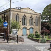
I may not personally be a fan of evangelical Christianity, but at least they keep the place looking nice. It's still very tidy since the recent renovation, installaltion of solar panels on the roof and repainting of the HOPE CHAPEL sign.
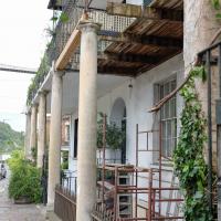
I was concerned about the state of Rock House, or at least its southern half, the last time I took a closer look at it while passing. Happily it seems to have been bought by someone prepared to fix up that drooping balcony. Here's hoping these repairs continue and my next photo of the place shows both sides of this old house (dated back to at least 1731 by a William Halfpenny engraving, no matter what the Listing says.)
Just behind Rock House you can see a bit of the Colonnade, sawn off at the end to make room for the widened Hotwell Road, I believe. Back in the day, according to 1925's The Bristol guide; being a complete ancient and modern history of the city of Bristol, the Hotwells and Clifton:
For those who prefer exercise to silting, there is the Colonade with shops, built beneath the rocks, and a parade about 800 feet long, shaded with trees, by the side of the river, so that the company may enjoy a dry and pleasant walk when it rains, or an airy, cool, and shady walk in the warmest season: also during the influx and efflux of the river, they may be entertained with the sight of the Merchant's ships, Steam packets, and Coasting vessels that generally pass up or down.
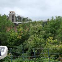
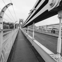
The reward at the top is the viewing platform of the Suspension Bridge, always busy with tourists.
I was actually planning to take an unexpected short-cut through a pub as an interesting little diversion on this wander, but sadly the pub was closed—I suppose before midday it's a bit of a reach to expect any pub to be open, even on a Saturday—so I headed for the shops instead. I'll have to do the short-cut trip one afternoon...
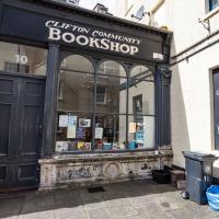
First I browsed the books at Rachel's & Michael's Antiques on Princess Victoria Street, where I bought CFW Dening's Old Pubs of Bristol as it mentions Hotwells a few times, then I grabbed my lunch from Parsons Bakery. There didn't seem to be anything new or interesting to snap along the way, so we'll now skip to the last couple of photos I took on my way home...
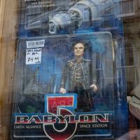
A random reminder of a TV show of my youth: Londo Mollari, the Centauri Ambassador to Babylon 5. Spotted in the window of the Oxfam shop on Victoria Street after I grabbed a coffee from Foliage Cafe.
I went out simply wanting to knock off the very last little unwalked section of Clanage Road, over by Bower Ashton, which has been annoying me for a while as it's quite close by and I've walked the other bits of it several times. So, my plan was to nip over to Greville Smyth Park via a slightly unusual route to wander Clanage Road and tick it off.
Along the way, though, I inevitably got a bit distracted. I took a few photos of Stork House, a grand Hotwell Road building that's recently been done up a bit (I imagine it's student lets, though I'm not sure) and which I found a reference to in a book about the Port Railway and Pier the other week, and also tried to match up a historical photo of Hotwells before the Cumberland Basin Flyover System laid it waste, which included some interesting markers I'll have to do a bit more digging into...
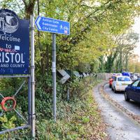
Because yes, we have just had a little excursion into Somerset, technically. So welcome back to Bristol, home of traffic jams.
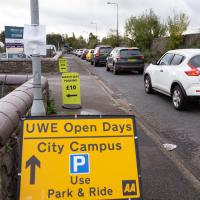
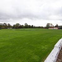
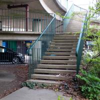
So that's why all the cars are there—not for the Open Day, it turned out; it's the other signs that are the giveaway. Somewhere, some people are committing a sport.
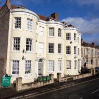
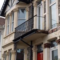
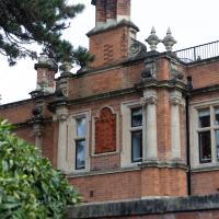
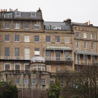
I've always loved the bow windows; if you look closely you'll see the window frames are slightly curved to match the curvature of the walls. Must be quite pricey to have repairs done, I'll wager.
Stork House was the Stork Hotel back when the Bristol Port Railway and Pier, which connected Hotwells with a deep-water pier at Avonmouth, was in its heyday.
The Stork Family Hotel at Hotwells sought custom by advertising to seamen on ships arriving at Avonmouth, a combined rail ticket to Bristol and meal in this hotel. The same concern also advertised bed, breakfast, hot evening meal and seven days’ ticket to Avonmouth by BPR for sixteen shillings a week.
— Colin Maggs, The Bristol Port Railway & Pier, Oakwood Press, 1975
I imagine this would have been quite an attractive deal to a sailor, who could stay in Hotwells with its vast plethora of pubs and other entertainments and pop back to his ship in the comparative wastelands of Avonmouth when necessary. (There would also have been plenty of sailors who were already quite used to hanging around in Hotwells while their ship was in town rather than waiting around at the new pier at Avonmouth, and familiar with the local facilities. Thinking about what other "facilities" there may have been for sailors makes me wonder again if the bit of the Hotwell Road that ended up being called "Love Street" might've been a bit of euphemism at some stage or other...)
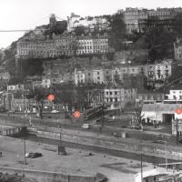
I found this image on Pinterest and as usual for that site it was annoyingly uncredited, but it seems to be from the book Hotwells, Spa to Pantomime, which I've just ordered direct from Bristol Books. Hopefully I'll be able to update the credit a bit when it arrives.
There's quite a lot in here that I didn't know about and will be researching a bit more, especially the Spa Assembly Rooms, which I think later turned into a school before being demolished for the flyover system, and also Anderson's workshop, a last vestige of the figurehead-carving industry.
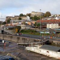
I was trying to recreate the angle of the old, pre-Cumberland Road Flyover System photo that comes next. I couldn't get the angle, mostly because of the height, but this seems to be shot from about the right direction.
...and I was right.
Incidentally, a brief aside for a rant: why the hell are self-storage places just like sodding gyms? You can't get a straight answer about how much storage costs from any of their websites. They just take your details and then you have to talk to some bloody salesman, and play each site off against each other to get what's alleged to be the best price. I think it must be some kind of price-fixing racket.
They didn't seem to be footballers. I asked Rich at the coffee van and he said it was a Rugby match. I don't know much about sportsball.
Saint Vincent's Spring
28 Dec 2020
Fractionally outside my one-mile zone, but I got curious about Saint Vincent's spring, whose last remnants you can see in a defunct drinking fountain on the Portway. Along the way I passed Gyston's cave, sometimes called St Vincent's cave, in the sheer wall of the gorge. It's now accessible by a tunnel from the observatory—I tried it about twenty years ago, I think, and still recall the vertiginous moment of looking down from the protruding balcony and realising that you could see straight through the grille floor to the drop below—but from what I can work out the tunnel is relatively recent. Before the tunnel was dug it was accessible only by access across the cliff face, which must have been even more terrifying.
This cave was first mentioned as being a chapel in the year AD 305 and excavations, in which Romano-British pottery has been found, have revealed that it has been both a holy place and a place of refuge at various times in its history.
A few different sources say that the cave became a hermitage and chapel to St Vincent following Bristol's early trading in Iberian wines; St Vincent of Saragossa is Lisbon's patron saint, and a lot of nearby things bear the name.
I'm not sure where the crossover of Vincent and Ghyston happens, though. On the giants Goram and Vincent (or Ghyston), Wikipedia says:
The name Vincent for one of the giants rests on the fact that at Clifton, at the narrowest point of the Avon Gorge, there was formerly an ancient hermitage and chapel dedicated to St Vincent, at or near the present cave in the cliff-face which bears his name. Another (apparently modern) version of the story calls the Clifton giant Ghyston, which is in fact the name, of obscure origin, for the whole of the cliff-face of the Avon Gorge at least as early as the mid-fifteenth century, in the detailed description of the Bristol area by William Worcestre. The place-name was personified to produce the giant's name. Vincent's Cave is called Ghyston cave or The Giant’s Hole in an article in the July 1837 issue of Felix Farley’s Bristol Journal.
In my research on the original Hot Well House, I've seen quite a few contemporary paintings which state their viewpoint as "from St. Vincent's Rock", so in the 16th century it seems the cliff-face name was typically St Vincent Rock rather than Ghyston's Rock, perhaps.
I am, as you can tell, no historian!
On the way, I also wandered around the base of the popular climbing area, which I think is the site of the old Black Rock quarry.
Desultory Coffee Wander
16 Apr 2021
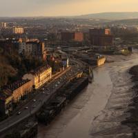
Another day, another quick dash out for a coffee. I did at least try to take a different route from normal, especially on the way back, where I yet again got a bit lost in the strange paths, flyovers and underpasses that make up the odd maze of pedestrian "infrastructure" among the concrete jungle between the west of Greville Smyth and my neck of the woods in Hotwells. I swear one day I'll take a turn I've not tried before and end up being gored by a Bristolian minotaur.
I'd heard there was going to be something of a wild party in Greville Smyth to mark the end of lockdown. It seems it may be the start of a regular thing, with a dance festival bringing 8,000 people to the park. I imagine I'll be able to hear it from my place, and therefore safely avoid it.
I decided to make my way across the water to Greville Smyth Park via a more cicuitous route than normal.
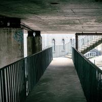
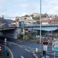
Some of the Cumberland Basin Flyover System's pedestrian pathways really do feel like you're making your way through a post-apocalyptic computer game.
I think I should have gone back down into the park to come back up my normal path, that leads to a place where you can walk under the flyover and get back on the bridge to Hotwells. As it is I just tried heading north and ended up having to cross four lanes of busy traffic.
That seems to be the failure of the pedestrian paths around here: if you know where you're going really well, the best you can hope for is not to make a wrong turn, and then you can end up going all the way around the houses, including quite often back the way you came, and might manage to use some of the provided underpasses and crossings and avoid the most dangerous traffic. But if you don't know them like the back of your hand and just try heading for the place you want to get to, that you can actually see, you'll be led entirely astray and end up in a variety of dead-ends.
Another Day, Another 50 Metres
29 May 2021
I met my friends Sarah and Vik at Riverside Garden Centre today; I needed to buy some compost for repotting my wildly-overgrowing aloe vera, and I went a little bit out of my way to knock off a stretch of Ashton Road. It was a pleasant enough walk in the surprisingly warm (and surprising-not-tipping-it-down-on-a-Bank-Holiday-weekend) weather.
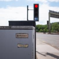
Traffic light control box, I assume. It's about as far from home as I am, as Plessey's headquarters were in Ilford, not far from where I grew up. Guessing this might be original gear from the late 1960s, when the flyover system was built.
It looked pretty amazing back in the day; it was a double-decker swing bridge with a control tower raised over the swing point. Here's another old snap, this one from a more similar viewpoint to mine.
When I moved to Hotwells, it was a pedestrian-only bridge, though one half of it still had the overgrown rail tracks from when it was a bottom-deck railway and top-deck road bridge. Since then it's been refurbished and is now combined pedestrian and Metrobus, with a guided channel for the buses. Amusingly, when it was first put in, they managed to make it too narrow for the buses. In fact, it's closed right now for "works on the guideway" so presumably they're still having problems.
There's an arguably better snap of it on an earlier wander, but at least you get a glimpse of the cool street art on the end of Baynton Road with this one. I still need to walk down Baynton Road, so perhaps I'll save talking about that piece for later...
Easter Monday Gardens and Flowers
18 Apr 2022
I didn't really set out with a theme of flowers and gardens in mind for this walk. I just fancied heading up to Clifton Village to get lunch. As it turned out, though, Spring was springing, so a minor theme emerged as I started off with the graveyard flowers of Hope Chapel and wandered up to see the beginnings of the new wildflower garden at Clifton Hill Meadow.
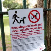
There's been some commotion on Nextdoor about the recent appearance of this sign. Lots of people who have been letting their dogs off their leads in the churchyard for decades have been rather up in arms. I'm not sure there's actually much danger of the rozzers issuing ASBOs or fines to the locals for that kind of infraction, though.
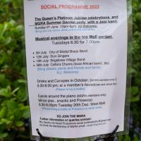
With a special Platinum Jubilee celebration on offer, too. I imagine The Mall Gardens will do that rather well.
The "Brigstowe Village Band" is a whimsical name. Brigstow—the bridge at the meeting point—is the origin of the modern "Bristol". Apparently they're "modelled on the village bands of Thomas Hardy’s day when local musicians played for all the local gatherings and celebrations."
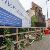
Where fly tipping happens, more like. This scrap of land (with a public bench hidden on the far end, against the back fence behind the red bins) has been a bit of an eyesore for years. I've never been a fan of public billboards.
Recently, though, a property developer has applied for planning permission for a block of flats here, and apparently fenced off the bit where the main entrance will be, even though it's fenced in this little corner of land that everyone assumed was public, council bench and all. And now it's attracted fly tippers, it seems.
I've tweeted at the councillor for the area, Alex Hartley, and he's said he's alerted the council and will try to investigate it/get it cleaned up, so here's hoping...
In the long run, maybe there will be some new flats instead of an ugly billboard and some dull fencing, and I'm all for that.
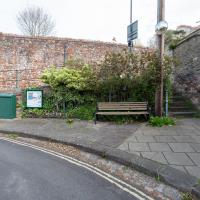
Strategically-placed grit box, because this tight blind (hence the mirror) zig-zag is hard enough work without a sheet of ice on the corner on a winter morning.
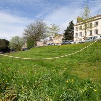
This is one of the three experimental areas. Nothing too apparent so far, but it's early dyas.
They were not open, gentle reader, despite their A board down the road. Ah well.
On the way back home, it's always worth a poke around the book section at the front of Rachel's and Michael's Antiques.
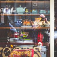
Also always worth a look, of course, is Audrey Hepburn, who seems to be peering at us from the right-hand end.
And on that somewhat random note, it's time to end our wander. I headed back home to tuck into a bit of work-supplied Easter egg, which was an unexpected bonus of being physically in the office last week!
A Quick Swing Past Ashton Court
05 Jun 2022
Another day not dissimilar to my last wander: I'm feeling a bit tired and rather than just moping around the house I thought I'd find some tiny bit of somewhere that I'd not yet walked and get outdoors. This time I headed for the Tobacco Factory Market in Bedminster, as I often do, but went the long way around via Ashton Court Mansion as I knew there were some footpaths and a small section of road I'd not ticked off up there. Finishing all the Ashton Court footpaths will be quite a long job, but you've got to start somewhere...
I did feel rather better by the time I got home, and, pretty much astoundingly given the weather forecast, managed to avoid the rain completely.
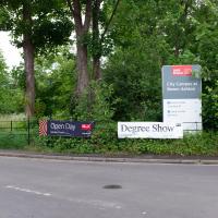
Ah, so not only is it the Bristol Triathlon next weekend, but it's also the UWE degree show. That's usually worth a look-see. Mind you, it's also Clifton Open Gardens, so maybe I'll see what the weather's like before I make a choice. UWE's Bower Ashton campus can be absolutely sweltering on a warm day, from what I remember, so I might be better off sipping Pimms in a garden if it's too sunny.
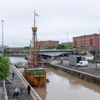
Fairly typical Bristol scene here, as the traffic is held up for a bridge swing caused by a replica of a 15th century caravel.
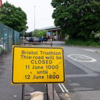
Ah, so it's the triathlon next weekend, then. The swimming bit is done in the Cumberland Basin, so I expect they'll be draining it and re-filling it with fresher water towards the end of the week. I wouldn't fancy it, even in a wetsuit.
Looks like work has finally started on the new flats on the site of the former railway depot/concrete factory/Bristol International Exhibition site.
For looks, I prefer the side with the mullioned windows, but neither of them seems that satisfactory to me, architecturally-speaking. It's all a bit mis-matched and asymmetrical, with very odd spacing here and there.
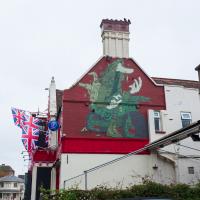
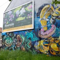
Pre-Upfest, as recently as April, Pikto's boy with the catapult still adorned the side of the Coopers Arms.
Not quite sure what to make of the replacement. It's much lower-contrast and less eye-catching, for me. Also, I'm so out of touch I have no idea if that's an original character or some famous pop-cuture reference.
Ahh, according to Natural Adventures it's "what looks like a Vaughn Bode Lizard, an Iconic character in the world of street art", and it's by an artist called Derm. I'd never heard of Vaughn Bodē or his Cheech Wizard and lizard apprentice, so it's not surprising this piece is going over my head. Probably more one for the real aficionados to appreciate.
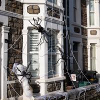
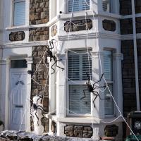
Bedminster
31 Oct 2020
Starting up close in Hotwells with a few bits around the Cumberland Basin flyover system, I walked to Bedminster and back on Hallowe'en, including finding some excellent decoration work.
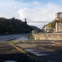
The spike of land with the dockkeepers' cottage on it has been cordoned off for the last couple months as I write this (on 4 Jan 2021; I'm processing my backlog.) Back in October you could wander up to the end unimpeded.
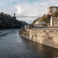
I don't normally do HDR photography, and I still find this looks a little unnatural, but hey, it was just an experiment.