Tagged: wes
John Carr's Terrace
16 Mar 2021
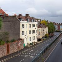
I wanted a nice simple lunch-hour walk that took me past a cafe today, and I managed to find the perfect road to knock off my list of targets to do it. Situated just off Jacobs Wells Road, right next to Queen Elizabeth's Hospital, John Carr's Terrace, and Rosebery terrace above it, which I'd completely forgotten existed, are a little cul-de-sac that many Bristolians will have wandered past a thousand times without ever seeing.
There's a reason it's next to QEH:
Known traditionally as "The City School", Queen Elizabeth's Hospital was founded by the will of affluent merchant John Carr in 1586, gaining its first royal charter in 1590.
John Carr's terrace itself isn't much to write home about, architecturally, but I like the secluded feel of it, and I really liked Rosebery Terrace with its little houses, commanding position and friendly, slightly tumbledown feel.
On the way home I popped into Foliage Cafe for a coffee and a very pleasant nutella and banana pastry, then walked home past the refurbishment of the old Thali Cafe into a new and interesting clinic...
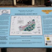
Now the well house seems to have stopped overflowing and the sign board is no longer cordoned off, it's time for a closer look. Lots of good info here.
Victoria Square Underpass
06 May 2021
I'm meant to be taking a little break from this project, but in my Victoria Square researches after my last walk I noticed a curiosity I wanted to investigate. The community layer on Know Your Place has a single photograph captioned, "The remains of an 'underpass' in Victoria Square".
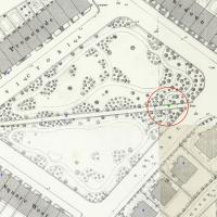
Looking back through the maps, I could see that there really did used to be an underpass across what used to be Birdcage Walk. I can only guess that it was there to join the two halves of the square's private garden that used to be separated by tall railings that were taken away during WWII. Maybe it was a landscaping curiosity, maybe it was just to save them having to un-lock and re-lock two gates and risk mixing with the hoi polloi on the public path in the middle...
Anyway. Intrigued, I popped up to Clifton Village this lunchtime for a post-voting coffee, and on the way examined the remains of the underpass—still there, but only if you know what you're looking for, I'd say—and also visited a tiny little road with a cottage and a townhouse I'd never seen before, just off Clifton Hill, and got distracted by wandering the little garden with the war memorial in St Andrew's churchyard just because the gate happened to be open.
EDIT: Aha! Found this snippet when I was researching something completely different, of course. From the ever-helpful CHIS website:
When there were railings all round the garden and down the central path, in order that the children could play together in either garden there was a tunnel for them to go through. This was filled in during the 1970s but almost at the south east end of the path if one looks over the low wall the top of the arches can still be seen.
I was just about starting to feel better—the antibiotics seemed to have kicked in for my dental issues, and it had been some days since I'd left the house, and I was at last starting to get itchy feet. So, a wander. But where? Well, there were a few industrial bits near Winterstoke Road in the Ashton/Ashton Vale areas of Bristol that needed walking. I knew they were likely to be quite, well, unattractive, frankly. So why not do them while I wasn't feeling exactly 100% myself? Maybe it would fit my mood. Hopefully you're also in the mood for a bit of post-industrial wasteland, for that's what some of this feels like...
Then, at the last minute, I thought again about the Bristol International Exhibition—I've got a book about it on the way now—and that gave me another goal, which could just about be said to be in the same direction, and I decided to walk significantly further than my normal 1-mile limit and try recreating another historical photo...
Sadly I don't know much about the Ashton area; it's just on the edges of my mile and I rarely have cause to go there. It's brimming with history, I'm sure: the whole South Bristol area rapidly developed from farmland to coal mines to factories to its current interesting mixture of suburbs and industrial work over the last few hundred years. As a more working class area less attention was paid to it by historians, at least historically-speaking, than the Georgian heights of Clifton, and much of it has been knocked down and reinvented rather than listed and preserved. I see here and there some of this lack is being addressed, but I'm afraid I'll be very light on the history myself on this wander, as most of my usual sources aren't throwing up their normal reams of information as when I point them at Clifton, Hotwells or the old city.
Here's the BBC report. This was posted on a telephone junction box in the "Daveside" area, the little strip of Festival Way that's used as a skate park in between the old railway depot and the White City allotments.
I went out simply wanting to knock off the very last little unwalked section of Clanage Road, over by Bower Ashton, which has been annoying me for a while as it's quite close by and I've walked the other bits of it several times. So, my plan was to nip over to Greville Smyth Park via a slightly unusual route to wander Clanage Road and tick it off.
Along the way, though, I inevitably got a bit distracted. I took a few photos of Stork House, a grand Hotwell Road building that's recently been done up a bit (I imagine it's student lets, though I'm not sure) and which I found a reference to in a book about the Port Railway and Pier the other week, and also tried to match up a historical photo of Hotwells before the Cumberland Basin Flyover System laid it waste, which included some interesting markers I'll have to do a bit more digging into...


