Tagged: an
Dowry Square Jaunt
16 Nov 2020
A quick lunchtime jaunt to Dowry Square, which is very close to me but, being effectively a cul-de-sac as well as a square, I've probably only circumnavigated a couple of times in the last couple of decades.

As I said in another photo, I've not been in here since it changed from being a Persian restaurant called Shiraz. I hear it's very good, but I didn't even spend much time in restaurants in the Beforetimes. You can see me in the reflection there, so I suppose this is technically a selfie :)
Tags: Bristol Places UK onemilematt united kingdom Hotwells
Auto-Tags: Building Facade Font Door Waste container Waste containment Street Retail Magenta Fixture Awning Road surface House Window Signage
Text Recognition Tags: Meadowe Indian Rassasy Unique Indian Dining Meadwca dela an No. 27a pirite 375A Meadowe Indian Rassasy Unique Indian Dining Meadwca dela an No. 27a pirite 375A
Bedmo and Ashton Court
21 Nov 2020
A rather more wide-ranging weekend wander with Sarah and Vik, taking in some mock Tudor bits of Bedmo (I should note that I've subsequently been corrected to "Bemmie", but I'm an outsider and have been calling it "Bedmo" for short for decades...), a chunk of Ashton, a path up Rownham Hill called Dead Badger's Bottom(!), The Ashton Court estate, a bit of the UWE campus at Bower Ashton, and some of the Festival Way path.
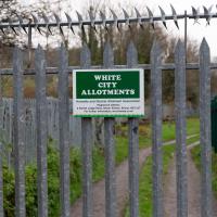
Gosh. I had no idea why it's called the White City Allotments, but apparently:
Bristol International Exhibition opened in May 1914 promising to be 'a place of pleasure and delight', celebrating 'the resourcefulness and progress of Great Britain and her Dominions'. 32 acres in Ashton Gate were transformed by palaces and pavilions. It quickly became known as the ‘White City’ because of the plaster used on the temporary buildings.
Tags: Bristol Places UK onemilematt united kingdom Festival Way cycle path footpath White City Allotments allotments history name
Auto-Tags: Property Plant Fence Wood Land lot Vegetation Grass Wire fencing Home fencing Landscape Woody plant Rural area Grass family Picket fence Groundcover
Text Recognition Tags: WHITE CITY ALLOTMENTS Hotets and Distriet Aotment Assoolation ake Lad a, oer an bri, 5 Fe e ilort d WHITE CITY ALLOTMENTS Hotets and Distriet Aotment Assoolation ake Lad a, oer an bri, 5 Fe e ilort d
Underpass
25 Nov 2020
A quick lunchtime jaunt for coffee. I've often wondered about the dots on the wall of the underpass. Apparently they're not intelligible Braille. Maybe it's Marain :D
Coincidentally, I deployed the word "corral" in an email the other day. I double-checked my spelling first, though.
Tags: Bristol Places UK onemilematt united kingdom
Auto-Tags: Drinkware Drink Cylinder Gas Font Tints and shades Carmine Waste containment Art Road surface Plastic bag Liquid Magenta Plastic Metal
Text Recognition Tags: Yes GOVT PRACONIAN ALIENS AT WORK Theyre gekking ready to Curl Cull an e6 S ALL! 96-97 % 200... ALef... Yes GOVT PRACONIAN ALIENS AT WORK Theyre gekking ready to Curl Cull an e6 S ALL! 96-97 % 200... ALef...
Nothing New
02 Dec 2020
This may be the very first time I've gone for a One Mile Matt wander and not actually gone down any new roads, trod any new steps. I just wanted a coffee, frankly, so I went the same old way to Imagine That in the marina and back again.

This is the current plan to replace the caravan park
Tags: Bristol Places UK onemilematt united kingdom baltic wharf
Auto-Tags: Property Light World Architecture Font Line Sky Material property Natural landscape Publication Real estate Adaptation Landmark Landscape Travel
Text Recognition Tags: BALTIC WHARFI NEW HOMES FOR BALTIC WHARF Hew the propesed deveinpmemt cend oek frem the Flating Harter WHAT IS PROPOSEO FOR BALTIC WHARF? WHY DO WE NEED MORE NEW HOMES? Goram Homes, Bristol City Council's housing company, has partnered with Hil to propose transformational plans for Baltic Whart This would provide approsimately 165 new homes, including 406 affordable. It is widety acknowledged that the curent housing crisis has led to the under provision of housing and particularly atfordable housing within Bristol. Although much is being done in the City to address the crisis, there are key issues with affordability, rough sleeping, and lack of social housing Bristol currently has over 13,000 famlies on the affordable housing register and a further 710 people in temporary accommodation. The aim is to create a vibrant destination on the Floating Harbour with homes, retail, restaurants and commercial spece, one that is well connected to local walking and cycling routes, seamiessly integrates with the historic setting and capitalises on the waterfrort setting with expansive views across the lamous Bristol townscape. Comparing house prices in Bristol to those in other Core Cities in the decade between 2008 and 2018 indicated that Bristol had the highest average housing costs of all the Core Cities in this period, and also the highest percentage Increase - over S6, compared to a UK average increase in costs of just over 32 The site is the Boltik Wharf Carian Club, The site is owned by Bristol City Counci and as part of the overarching ambition to deliver high quality homes, this site has been identified as a site capable of providing bomes for Bristal. GORAM HOMES 出Hill Goram Homes was founded in 2018 as part ol an initiative from Bristol City Counci, wich the ambition to increase the provision of nea hemes in the city and to meet affordable housing requirements without compromising on build quality Goram Homes is a subsidary of Bristol Holding Ltd, HIl is an award-winning 5 star housebuilder, creating a range of beautiful and awardwinning new homes across the south of England. They are a leading partnership developer, delivering distinctive and award-winning new homes, having been named Housebuilder of the Year, medium and large, in 2018. which is wholly owned by Bristol City Council Goram is set up to deliver mised tenure housing on a joint ventune basis and our share of profit wil feed back into the funding of council servicel BALTIC WHARFI NEW HOMES FOR BALTIC WHARF Hew the propesed deveinpmemt cend oek frem the Flating Harter WHAT IS PROPOSEO FOR BALTIC WHARF? WHY DO WE NEED MORE NEW HOMES? Goram Homes, Bristol City Council's housing company, has partnered with Hil to propose transformational plans for Baltic Whart This would provide approsimately 165 new homes, including 406 affordable. It is widety acknowledged that the curent housing crisis has led to the under provision of housing and particularly atfordable housing within Bristol. Although much is being done in the City to address the crisis, there are key issues with affordability, rough sleeping, and lack of social housing Bristol currently has over 13,000 famlies on the affordable housing register and a further 710 people in temporary accommodation. The aim is to create a vibrant destination on the Floating Harbour with homes, retail, restaurants and commercial spece, one that is well connected to local walking and cycling routes, seamiessly integrates with the historic setting and capitalises on the waterfrort setting with expansive views across the lamous Bristol townscape. Comparing house prices in Bristol to those in other Core Cities in the decade between 2008 and 2018 indicated that Bristol had the highest average housing costs of all the Core Cities in this period, and also the highest percentage Increase - over S6, compared to a UK average increase in costs of just over 32 The site is the Boltik Wharf Carian Club, The site is owned by Bristol City Counci and as part of the overarching ambition to deliver high quality homes, this site has been identified as a site capable of providing bomes for Bristal. GORAM HOMES 出 Hill Goram Homes was founded in 2018 as part ol an initiative from Bristol City Counci, wich the ambition to increase the provision of nea hemes in the city and to meet affordable housing requirements without compromising on build quality Goram Homes is a subsidary of Bristol Holding Ltd, HIl is an award-winning 5 star housebuilder, creating a range of beautiful and awardwinning new homes across the south of England. They are a leading partnership developer, delivering distinctive and award-winning new homes, having been named Housebuilder of the Year, medium and large, in 2018. which is wholly owned by Bristol City Council Goram is set up to deliver mised tenure housing on a joint ventune basis and our share of profit wil feed back into the funding of council servicel
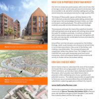
This is the current plan to replace the caravan park
Tags: Bristol Places UK onemilematt united kingdom baltic wharf
Auto-Tags: Property Architecture Font Line Urban design Real estate Landmark Screenshot Publication Facade Cloud Landscape Advertising City History
Text Recognition Tags: BALTIC WHARF WHAT ELSE IS PROPOSED OTHER THAN HOMES? Our aim is to create new public spaces, with a mix of uses, that encourage a sense of community and social inclusiveness, that are accessible to all, and which prioritise walking and cycling. social interaction and physical activity for a high quality of ife. The design of these public spaces wil draw heavily on the site's historical contet and harbournide setting, producing a unique space that acknowledges the area's history as a busy and dynamic working dockyard. This will be achieved with materials and public art that reference the site's heritage. The proposals will make the most of the waterfront location with seating steps and social spaces with striking views across the water for residents and locats. in contrast, private and semi-private amenity spaces on terraces and roof gardens will be calm and relasing with comfortable furniture and colourful and biodiverse planting. Ground floor commercial space is proposed on the harbour frontage, which could include a mix of places to eat and drink, in turn enhancing activity in this comer of the harbour and creating a new destination. The commercial space will complement rather than detract from The Cottage Inn and Underlall Yard, and could incorporate some local social enterprises, which will enhance footfal and promote social activity to further eniven the harbour setting Above: How theo cite cou lockhom Cumberlard Hoad HOW CAN I FIND OUT MORE? Goram Homes is keen to understand the views of local people and would like to encourage people to have their say. Given COMD restrictions, we have launched a dedicated website for the project, which provides more detail about what is proposed, whilst addressing some ef your questions and potential concems. The website also provides an opportunity to have your say on our plans before they are finalised and submitted in a planning application to Bristol City Councit Abover The proposals withintheir contot Belaw: The emergng site layout www.balticwharfhomes.com We have also organised an ontine presentabion for the wider community at Tpm on Thursday Bth October 2020 1o find out more, ask questions and give us their thoughts, Ifyou would like to attend, please visit this link to sign-up: www.balticwharfhomes.com/presentation If you are unable to visit either website, please give our Co Isultation team a call on 07342 039 444 (during office hours), who can book you in and make olternative amangements to get involved in the session, or provide all information in an alternative fomat appropriate for you BALTIC WHARF WHAT ELSE IS PROPOSED OTHER THAN HOMES? Our aim is to create new public spaces, with a mix of uses, that encourage a sense of community and social inclusiveness, that are accessible to all, and which prioritise walking and cycling. social interaction and physical activity for a high quality of ife. The design of these public spaces wil draw heavily on the site's historical contet and harbournide setting, producing a unique space that acknowledges the area's history as a busy and dynamic working dockyard. This will be achieved with materials and public art that reference the site's heritage. The proposals will make the most of the waterfront location with seating steps and social spaces with striking views across the water for residents and locats. in contrast, private and semi-private amenity spaces on terraces and roof gardens will be calm and relasing with comfortable furniture and colourful and biodiverse planting. Ground floor commercial space is proposed on the harbour frontage, which could include a mix of places to eat and drink, in turn enhancing activity in this comer of the harbour and creating a new destination. The commercial space will complement rather than detract from The Cottage Inn and Underlall Yard, and could incorporate some local social enterprises, which will enhance footfal and promote social activity to further eniven the harbour setting Above: How theo cite cou lockhom Cumberlard Hoad HOW CAN I FIND OUT MORE? Goram Homes is keen to understand the views of local people and would like to encourage people to have their say. Given COMD restrictions, we have launched a dedicated website for the project, which provides more detail about what is proposed, whilst addressing some ef your questions and potential concems. The website also provides an opportunity to have your say on our plans before they are finalised and submitted in a planning application to Bristol City Councit Abover The proposals withintheir contot Belaw: The emergng site layout www.balticwharfhomes.com We have also organised an ontine presentabion for the wider community at Tpm on Thursday Bth October 2020 1o find out more, ask questions and give us their thoughts, Ifyou would like to attend, please visit this link to sign-up: www.balticwharfhomes.com/presentation If you are unable to visit either website, please give our Co Isultation team a call on 07342 039 444 (during office hours), who can book you in and make olternative amangements to get involved in the session, or provide all information in an alternative fomat appropriate for you
Alma Vale
06 Dec 2020
I wasn't really feeling it when I set out today, on my first car-assisted wander. By the time I'd parked on Alma Vale Road in Clifton it was just starting to rain and I picked my way about in quite a desultory way. It felt strange, as I was very familiar with the area because I'd walked through it hundreds of times when I worked at the top of Whiteladies Road, and used to walk up the hill from Hotwells and through Clifton to get there, and back again, every day.
Then a complete coincidence seemed to make the change I'd been hoping for. I was standing taking a photo of Christ in the front garden of All Saints church when a couple of people walked out of the front door. I got talking with a lady I took to be part of the ministerial team, who invited me to come in and look around—something I'd always wanted to do on the morning commute. (I think we connected a bit when I recognised the name John Piper, who did the amazing windows—I learned about him while I was at Warwick, through his connections to Coventry Cathedral.
I left with much more of a spring in my step, wandered around the area a bit more, finally working out that the tennis courts I used to pass every morning are those of Clifton Lawn Tennis Club, and finally grabbing an excellent Hungarian sausage hot dog from the Budapest Cafe. I feel a lot better now than I did before I went out.

Tags: Bristol Places UK onemilematt united kingdom Clifton
Auto-Tags: Property Building Door Architecture Wall Facade Gas Window Urban area Font Machine Street Fixture City Automated teller machine
Text Recognition Tags: AN CUISUIE BRISTOL RAJ BRISTOL BRISTOL Raj Raj AN CUISUIE BRISTOL RAJ BRISTOL BRISTOL Raj Raj
Rainy Clifton
13 Dec 2020
A long walk around Cliftonwood and Clifton with my friend Lisa, taking in some of the 12 Days of Christmas display at Queens Parade, picking up a take-away coffee from Pinkmans of Park Street, and poking our heads up against the glass of SS Peter and Paul Catholic Cathedral.

We wondered how often someone applied for consent to perform Archery on Brandon Hill.
Tags: Bristol Places UK onemilematt united kingdom
Auto-Tags: Plant Font Wood Terrestrial plant Recreation Signage Poster Soil Sign Sports equipment Traffic sign Advertising Trunk Landscape Number
Text Recognition Tags: Bristol Parks and Estates Byelaws apply here to help people enjoy parks and green spaces responsibly For more information www.bristol.gov.uk/byelaws To report an issue www.bristol.gov.uk Permitted Permitted only with consent Not permitted Cenete pcing Raberse peted cone asly Chaging for ey ty Gaba Tshing Camping Puhawnd Ging Anhery Fesports Evee No can Harng fwie Pyingeld nd n at Gelf ing ef water co Dag Faing Uting Bristol Parks and Estates Byelaws apply here to help people enjoy parks and green spaces responsibly For more information www.bristol.gov.uk/byelaws To report an issue www.bristol.gov.uk Permitted Permitted only with consent Not permitted Cenete pcing Raberse peted cone asly Chaging for ey ty Gaba Tshing Camping Puhawnd Ging Anhery Fesports Evee No can Harng fwie Pyingeld nd n at Gelf ing ef water co Dag Faing Uting
I went to have a peep at the giant sinkhole that's opened up in Canynge Square—ironically, having recently discovered the gardens were public I'd had the (triangular!) square on my list to re-visit for a few days, but now there's no entrance to the gardens due to the danger. The area was well fenced-off for safety, but I tried to get a couple of photos from behind the barriers.
I also explored the area around Camp Road, an real melange of architectures, one of the most mixed-up areas I've seen in Clifton, in fact, and confirmed my friend Claire's suspicion that an earlier snap of a sign from Manilla Road was in fact for a fire hydrant. Nice.

Tags: Bristol Places UK onemilematt united kingdom Clifton Village
Auto-Tags: Tire Wheel Motor vehicle Automotive tire Vehicle Automotive exterior Tread Automotive wheel system Font Fender Bumper Commercial vehicle News Vehicle door Truck
Text Recognition Tags: Dear negbour od 14 aund 1 ene unknoun tomeit the extensebuling wo ur wy on the house t to umber, damag ringwide truc/orry the d t eoistently parked at the te for seeal wee ng and aown and iemrahing ut you to ask i you can al e regivtration number of any detavsal regarding thê truck, bu yourself have hat yeur demaged recently as lythis ne an isolated moa rm what remenber itwosa uck wth aopen ar ba end for toading up scatfording etc, uimilar to this steckiel Wiknson The driver contacted my partrer aver the interc o seek the owner before breakin offand SL alter being informed the persen te wistalng too couid put him in comt with me herefore ey that if this persan has degnother cars uch as yours. he is kely t repeat behavidur in the future and nat act to infem you 00 have had amy dimage to yaur car recently or an emember and share any details of the Tack in question or if you saw what haupened t would be enainouly acoreciated f you would Lotact me va teatical 0766994321. Orvamall at simonmattheapayne@nai.com Althe best, Mecry Christmaes and stay sale Smbeumbi The Fosseway Dear negbour od 14 aund 1 ene unknoun tomeit the extensebuling wo ur wy on the house t to umber, damag ringwide truc/orry the d t eoistently parked at the te for seeal wee ng and aown and iemrahing ut you to ask i you can al e regivtration number of any detavsal regarding thê truck, bu yourself have hat yeur demaged recently as lythis ne an isolated moa rm what remenber itwosa uck wth aopen ar ba end for toading up scatfording etc, uimilar to this steckiel Wiknson The driver contacted my partrer aver the interc o seek the owner before breakin offand SL alter being informed the persen te wistalng too couid put him in comt with me herefore ey that if this persan has degnother cars uch as yours. he is kely t repeat behavidur in the future and nat act to infem you 00 have had amy dimage to yaur car recently or an emember and share any details of the Tack in question or if you saw what haupened t would be enainouly acoreciated f you would Lotact me va teatical 0766994321. Orvamall at simonmattheapayne@nai.com Althe best, Mecry Christmaes and stay sale Smbeumbi The Fosseway
I went to get my first dose of the Oxford/AstraZeneca Covid-19 vaccine today. Handily, the vaccination centre was Clifton College Prep School in Northcote road, next to Bristol Zoo, a road that's just within my 1-mile range that I hadn't visited before.
I parked up near Ladies Mile and tried to find a few of the tracks marked on the map I'm using, but couldn't see most of them. Whether that's just because they've disappeared over time, or with the recent lack of use or waterlogging from the 24 hours of rain we just had, I'm not sure. It was a pretty fruitless search, anyway.
The vaccine shot was virtually the same setup as when I got my winter flu jab back in November, except for the venue. I snapped a couple of pictures of the school while I was there, but I was in and out in five minutes, and you probably don't want to linger around a vaccination centre, I suppose.
Instead I wandered around the compact block of the Zoo, now sadly scheduled for closure. By coincidence I finished E H Young's Chatterton Square this morning: set in Clifton (fictionalised as "Upper Radstowe") near the Zoo, the occasional roars of the lions that can be heard by the residents of the square (Canynge Square in real life) form part of the background of the novel. The book's set in 1938 (though written and published post-war, in 1947). It seems a shame that the incongruous sounds of the jungle will no longer be heard from 2022. All I heard today were some exotic birds and, I think, some monkeys.
I was told not to drive for fifteen minutes following the jab, so I wandered out of my area up to the top of Upper Belgrave Road to check out an interesting factoid I'd read while looking into the history of the reservoir at Oakfield Road, that the site of 46 Upper Belgrave Road was a bungalow, shorter than the adjacent houses, and owned by Bristol Water, kept specifically low so that the pump man at Oakfield Road could see the standpipe for the Downs Reservoir (presumably by or on the water tower on the Downs) and turn the pump off when it started overflowing. Sadly I couldn't confirm it. There is one particularly low house on that stretch, but it's number 44, and though small, it's two-storey, not a bungalow, so nothing really seems to quite fit in with the tale.
I'm writing this about nine hours after getting the jab, by the way, and haven't noticed any ill effects at all. My arm's not even sore, as it usually would be after the normal flu jab. In twelve weeks I should get an appointment to get the second dose.
Tags: Bristol Places UK onemilematt united kingdom Clifton Clifton College
Auto-Tags: Building Window Property Road surface Sky Wood Brickwork Brick Urban design Fixture Residential area Road Facade House Tree
Text Recognition Tags: NO PA RKIN G AN JKIND NO PA RKIN G AN JKIND
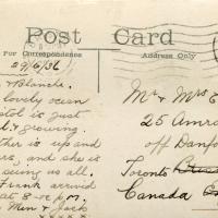
I bought a vintage post card from eBay this week. It's a well-known photo of the Hotwells landing stage, showing what's likely to be a P&A Campbell paddle steamer moored there. (Just yesterday I snapped a photo of their buoy on display at Underfall Yard with its information sign.) It was posted from here to Canada in 1936, and has now returned via a presumably quite circuitous route.
Local journalist Maurice Fells (really local—I could probably hit his house with a well-flung teacake from here) notes in The A-Z of Curious Bristol (£) that:
For tens of thousands of people, the pier at Hotwells was the starting point of their day trip as they boarded steamers with names like Glen Avon, Glen Usk and Britannia. The salty tang of the sea was never far away as the steamers headed for Ilfracombe, Weston-super-Mare, Clevedon and Portishead on the Devon and Somerset coast and Barry, Porthcawl and Tenby in South Wales.
The landing stage is long-abandoned. A variety of economic issues, including fuel prices, the increasing prevalence of the motor car, the construction of the Severn Crossing giving easier access to Wales, and the collapse of Clevedon Pier during safety testing in 1970, which prevented larger pleasure boats from stopping at the resort, all led to dwindling trade.
I went to have a poke about there today, not staying for long as it's a cold day and the wind was biting. I couldn't reproduce the postcard's view—you'd need to risk life, limb and presumably a trespass prosecution—but I did try to judge the rough viewpoint and angle of the photo by lining up with Rock House, the Colonnade and the Suspension Bridge and snapped a photo looking back to where the original photographer would have stood on the pontoon.
This Bristol City Docks history page has many good photos of the landing stage and the nearby Port and Pier Railway line (whose tunnel I was in the other day) and the Hotwells Halt railway station, which was just the other side of the suspension bridge from here.
Well, I think that's what it says.
Tags: Bristol Places UK onemilematt united kingdom Hotwells Avon Gorge river avon hotwell road landing stage pontoon
Auto-Tags: Handwriting Postcard Font Stamp seal Rubber stamp Mail Writing Paper Signature Letter Paper product Document Parallel Collectable Envelope
Text Recognition Tags: Post Card Address Only 5NE PENNY For Correspondence Bruilob 29/6/3l Dear Ein Hlonele, Had a lovely trif, Bruslol is Jual oeean 25 Amroth an. off banforild ave Tronts htato nt banada olaad Wonderful.rgrowring. Erns Mother is up and downolairs, and she is Soieilid oung Emma r Franh arrivid Set last at 8-0e f6m. Love from Menr fack us all, Post Card Address Only 5NE PENNY For Correspondence Bruilob 29/6/3l Dear Ein Hlonele, Had a lovely trif, Bruslol is Jual oeean 25 Amroth an. off banforild ave Tronts htato nt banada olaad Wonderful.rgrowring. Erns Mother is up and downolairs, and she is Soieilid oung Emma r Franh arrivid Set last at 8-0e f6m. Love from Menr fack us all,
Since setting up a search for Hotwells on eBay I've mostly managed to restrain myself from buying much (or in one case, was outbid, luckily for my finances.) However, I couldn't resist a 1902 flyer for a singalong at the Terrett Memorial Hall, which would have stood five minutes' walk from my flat, overlooking Howard's Lock.
I've found out a fair bit about this non-denominational seaman's mission, including tracking down both a Loxton drawing and an aerial photo of it. The main thing that's eluded me, ironically enough, is finding out who Terrett was, so as a Memorial Hall it didn't do a very good job 😀.
EDIT: Ah! Did a little more digging and found that the Bristol Archives has a Bristol Dock Company document on file called "William Terrett, Esq.; corresp. etc. re proposed erection of a Mission Hall at Cumberland Basin, 1892", so that might be worth a look once the Archives are properly open again. Given that:
Sarah Terrett died suddenly on 25 November 1889, aged 53, after speaking at a meeting of the White Ribbon Army, the temperance organization she had founded in 1878. Following her death many people sent letters of sympathy to her bereaved husband, William. One of these, from the Rev. W. F. James, a minister of the Bible Christians, makes for especially interesting reading. The Bible Christian denomination, to which Sarah and William belonged, was one of the smaller Methodist connexions, and had its heartland in rural Devon, the area where she had grown up. James recalled the hospitality he enjoyed when visiting the Terretts’ home, Church House, in Bedminster, south Bristol...
...I wonder if William Terrett built the hall in memory of his late wife. They were clearly just the kind of temperance movement people who would've founded a seaman's mission to get people together to have a nice non-alcoholic singsong rather than a night out on the tiles.
Anyway. This walk to grab a coffee from Hopper Coffee in Greville Smyth Park was mostly an excuse to post the leaflet, a few other things I found related to it, and some pictures of how the site looks now. I would suggest that the present day is not an improvement.
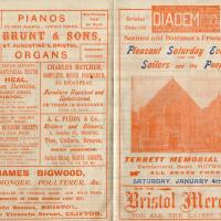
This was my random eBay purchase. I had no idea that the Terrett Memorial Hall had ever existed until I saw this leaflet up for sale.
There's some information on the hall on the Places of Worship database; as you can guess from the title of the leaflet it was basically a seaman's mission, with the aim "to promote the social, moral and religious welfare of sailors and provide sleeping accomodation for seamen, also free beds for destitute seafarers"
My favourite random thing on this leaflet is probably that the Surgeon Dentist is called Mr Heal.
Tags: Bristol Places UK onemilematt united kingdom Hotwells Cumberland Basin Flyover System Cumberland Piazza Cumberland Basin Terrett Memorial Hall
Auto-Tags: Font Material property Publication Brickwork Paper Book Pattern Paper product Brick History Newsprint Book cover Rectangle Holy places Document
Text Recognition Tags: BE SURE YOU CET THE ROYAL F RASNC DIADEM UR Hire Parebane PIANOS As to ATSS. Bristol of the per Month. BY BEST MAKERS LUWEST PRICS FRACTICAL TEST PRIVES THL BESTIneorponated Seamen and Boatmen's Friend Society. District W. BRUNT & SONS, ST. AUGUSTINE'S, BRISTOL. Pleasant Saturday Evenings Instreinenta Instrunents ORGANS Repatred. Exthanged roR THE Sailors and the People. ANERICAN A ENOISH DENTITRY Prize Medal ARTIFICIAL TEETH. Mr. HEAL, Surgeon Dentist, CHARLES HATCHER, COMPLETE HOUSE FURNISHER, 20, BROADMEAD. 25, OLD MAHKEr STREET. BRISTOL. Furnituro Repaired and Upholstered, the t quaty OR TAKEN IN EXCHANGE. CASIL OR IHIRK. a An Metais C Monik s pmaro WET oF NGLANO AND SOUTH WALES A. C. PUDDY & Co. PRRMANENT BUILDING SOCIETY Hosiers and Glovers, SL Staphan's ureat, Bristat he sosh ANNUAL REPORT 3. Dolphie St., BRISTOL Ties, Collars, Braces, Re Men t i anora frebeYBARS Ma FOR DORIDWER AY TER WINTER UNDERWEAR. Parfect-fitting WHITE SHIRTS, in a . e e TERRETT MEMORIAL HALL, Cumberland Basin. HOTWELLS A dm, A Ere JAMES BIGWOOD, ALL SEATS PREE. FISHMONGER, POULTERER, &c. SATURDAY, JANUARY 4th, 1902. BUY THE Bristol Mercury LICENSED DEALER IN VENISON, GAME AND WILD FOWL IMPORTER oF PURE WENHAM LAKE IOE. Baldwin Street, BRISTOS, and Victoria Street, CLIFTON. FOR ALL THE LATEST NEWS. BE SURE YOU CET THE ROYAL F RASNC DIADEM UR Hire Parebane PIANOS As to ATSS. Bristol of the per Month. BY BEST MAKERS LUWEST PRICS FRACTICAL TEST PRIVES THL BESTIneorponated Seamen and Boatmen's Friend Society. District W. BRUNT & SONS, ST. AUGUSTINE'S, BRISTOL. Pleasant Saturday Evenings Instreinenta Instrunents ORGANS Repatred. Exthanged roR THE Sailors and the People. ANERICAN A ENOISH DENTITRY Prize Medal ARTIFICIAL TEETH. Mr. HEAL, Surgeon Dentist, CHARLES HATCHER, COMPLETE HOUSE FURNISHER, 20, BROADMEAD. 25, OLD MAHKEr STREET. BRISTOL. Furnituro Repaired and Upholstered, the t quaty OR TAKEN IN EXCHANGE. CASIL OR IHIRK. a An Metais C Monik s pmaro WET oF NGLANO AND SOUTH WALES A. C. PUDDY & Co. PRRMANENT BUILDING SOCIETY Hosiers and Glovers, SL Staphan's ureat, Bristat he sosh ANNUAL REPORT 3. Dolphie St., BRISTOL Ties, Collars, Braces, Re Men t i anora frebeYBARS Ma FOR DORIDWER AY TER WINTER UNDERWEAR. Parfect-fitting WHITE SHIRTS, in a . e e TERRETT MEMORIAL HALL, Cumberland Basin. HOTWELLS A dm, A Ere JAMES BIGWOOD, ALL SEATS PREE. FISHMONGER, POULTERER, &c. SATURDAY, JANUARY 4th, 1902. BUY THE Bristol Mercury LICENSED DEALER IN VENISON, GAME AND WILD FOWL IMPORTER oF PURE WENHAM LAKE IOE. Baldwin Street, BRISTOS, and Victoria Street, CLIFTON. FOR ALL THE LATEST NEWS.