Tagged: old
I managed to knock off a reasonable chunk of the roads I had left to walk around the University at the north-eastern extremity of my mile on this nice sunny walk. As well as being impressed by the number of big townhouses now occupied by various departments, I took some time on my way there to check out a war memorial, and some time on the way back to do a little extra wandering of Berkeley Square.
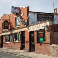
I noticed I had a few things on my "potential wanders" list that could all be done relatively close to home, and in a fairly straight line, so I set off at lunchtime to recreate a photo of a now-defunct pub, wander behind a Spar (which turned out to be more interesting than I'd expected, but I admit it's a low bar) and spend some time browsing in Dreadnought Books before coming home via a coffee from Spoke & Stringer, a little diversion up Gasworks Lane and a tiny bit of the Rownham Mead estate I'd somehow previously skipped.
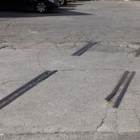
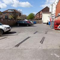
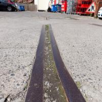
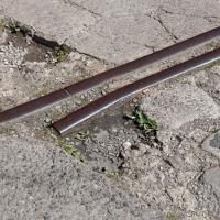
Remnants of the docks railway. These ran around the harbour to Ashton Avenue Bridge to the west, and along to the main Goods Depot at Anchor Lane to the east.
I think this may be the last visible remnant of the harbour railway on this entire stretch of the Hotwell Road. There may still be some tracks around Canons March—that whole area south of Anchor Road had a lot of rail lines—but I've not seen any others west of Jacobs Wells Road.
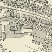
On Know Your Place you can check out old maps of Bristol. Sadly there doesn't seem to be an easy way of linking to a particular map/location. Still, here's a little screenshot of the 1898-1939 layer. These tracks are still there on the later 1949 map, so at least this section survived the war, I think.
Having checked Wikipedia I think this section, which ran from Canons Marsh to Ashton Avenue Bridge and then on to the south was created in 1906, and closed in 1965.
This map fragment will be © Ordnance Survey.
Of Bridges and Buoys
04 Mar 2021
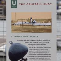
A trip to Imagine That coffee, so no fresh roads knocked off my list, but I stopped off to snap a couple of the engineering-related bits of the docks: the Campbell Buoy (used by P&A Campbell for mooring their paddle steamers) and Brunel's "other" bridge, the foot/horse swing bridge that now sits sadly disused in the shadow of the Plimsoll Bridge at Howard's Lock.
I got interested in Bristol's medieval water supplies after poking around near Jacobs Wells Road and Brandon Hill. It was during that research I found out about a pipe that's still there today, and, as far as I know, still actually functioning, that was originally commissioned by Carmelite monks in the 13th century. They wanted a supply of spring water from Brandon Hill to their priory on the site of what's now the Bristol Beacon—Colston Hall, as-was. It was created around 1267, and later, in 1376, extended generously with an extra "feather" pipe to St John's On The Wall, giving the pipework its modern name of "St John's Conduit".
St John's on the Wall is still there, guarding the remaining city gate at the end of Broad Street, and the outlet tap area was recently refurbished. It doesn't run continuously now, like it did when I first moved to Bristol and worked at the end of Broad Street, in the Everard Building, but I believe the pipe still functions. One day I'd like to see that tap running...
There are a few links on the web about the pipe, but by far the best thing to do is to watch this short and fascinating 1970s TV documentary called The Hidden Source, which has some footage of the actual pipe and also lots of fantastic general footage of Bristol in the seventies.
On my walk today I was actually just going to the building society in town, but I decided to trace some of the route of the Carmelite pipe, including visiting streets it runs under, like Park Street, Christmas Street, and, of course, Pipe Lane. I also went a bit out of my way to check out St James' Priory, the oldest building in Bristol, seeing as it was just around the corner from the building society.
There are far too many pictures from this walk, and my feet are now quite sore, because it was a long one. But I enjoyed it.
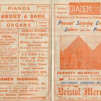
Since setting up a search for Hotwells on eBay I've mostly managed to restrain myself from buying much (or in one case, was outbid, luckily for my finances.) However, I couldn't resist a 1902 flyer for a singalong at the Terrett Memorial Hall, which would have stood five minutes' walk from my flat, overlooking Howard's Lock.
I've found out a fair bit about this non-denominational seaman's mission, including tracking down both a Loxton drawing and an aerial photo of it. The main thing that's eluded me, ironically enough, is finding out who Terrett was, so as a Memorial Hall it didn't do a very good job 😀.
EDIT: Ah! Did a little more digging and found that the Bristol Archives has a Bristol Dock Company document on file called "William Terrett, Esq.; corresp. etc. re proposed erection of a Mission Hall at Cumberland Basin, 1892", so that might be worth a look once the Archives are properly open again. Given that:
Sarah Terrett died suddenly on 25 November 1889, aged 53, after speaking at a meeting of the White Ribbon Army, the temperance organization she had founded in 1878. Following her death many people sent letters of sympathy to her bereaved husband, William. One of these, from the Rev. W. F. James, a minister of the Bible Christians, makes for especially interesting reading. The Bible Christian denomination, to which Sarah and William belonged, was one of the smaller Methodist connexions, and had its heartland in rural Devon, the area where she had grown up. James recalled the hospitality he enjoyed when visiting the Terretts’ home, Church House, in Bedminster, south Bristol...
...I wonder if William Terrett built the hall in memory of his late wife. They were clearly just the kind of temperance movement people who would've founded a seaman's mission to get people together to have a nice non-alcoholic singsong rather than a night out on the tiles.
Anyway. This walk to grab a coffee from Hopper Coffee in Greville Smyth Park was mostly an excuse to post the leaflet, a few other things I found related to it, and some pictures of how the site looks now. I would suggest that the present day is not an improvement.
This was my random eBay purchase. I had no idea that the Terrett Memorial Hall had ever existed until I saw this leaflet up for sale.
There's some information on the hall on the Places of Worship database; as you can guess from the title of the leaflet it was basically a seaman's mission, with the aim "to promote the social, moral and religious welfare of sailors and provide sleeping accomodation for seamen, also free beds for destitute seafarers"
My favourite random thing on this leaflet is probably that the Surgeon Dentist is called Mr Heal.
A London Wander in Southville
10 Apr 2021
There's a bit of Southville that I've been meaning to get to for some time, where the streets seem to take some strong inspiration from London. There's a Camden Road that crosses with an Islington Road, and a Dalston Road, even an Edgeware Road. For me these names are more evocative than the rather more exotic names I passed by to get there—Sydney Row or Hanover Place, say, because I've actually been to the places in London. The last time I was in Islington I saw Monkey Swallows the Universe play at The Angel, and I can't think of Camden without remembering a gondola trip with my friend Tara where a cheery youth played Beatles music for us on a saz...
I really liked this little area, with its mostly well-kept pretty houses and hints here and there of the creative side of the residents. It's arty and down-to-earth at the same time, and I wouldn't mind living there, I think.
On the way there I got the chance to walk through Underfall Yard for the first time in a while, and on the way back I had my first take-away hot food for many months, grabbing some crispy fried squid from the excellent Woky Ko at Wapping Wharf.
The more I research it, the more I find that Hotwells had far better transport links back in Victorian and Edwardian times than it has today. Along with buses that went to more useful places than the City Centre, there were trams, the funicular up to Clifton, the landing stage for paddle steamer services and two railway stations all within easy walking distance of me.
Today I took a day off work as preparation for doing the bookkeeping for my tax return1, and took a wander along to the site of what would have been my nearest station, Hotwells (or Clifton, as it started out in life), nestled in the shadow of the suspension bridge, the Bristol terminus of the Bristol Port Railway and Pier.
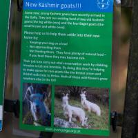
From there I wandered down the Portway, following the original line, until I got to the area around Sneyd Park Junction, where the tunnel from the slightly later Clifton Extension Railway joined up with this originally-isolated BPR line. Then I headed up to Clifton through the "goat gully" at Walcombe Slade, seeing the few above-ground bits of evidence of the tunnel (which is still in regular use) along the way.
It was a lovely day, and a good walk, and it was interesting to daydream of the times when I could have walked a few minutes from my flat down to Dowry Parade, caught a short tram ride to Hotwells Stations, and then headed from there to Avonmouth, perhaps even to board a transatlantic passenger service. The completion of the Clifton Extension Railway that linked the Avonmouth station with Temple Meads made relatively direct transatlantic travel from London via Bristol possible, with passengers travelling up from Paddington to Temple Meads, on to Avonmouth on the Clifton Extension Railway and Port Railway and Pier line, then perhaps catching a Cambpell's paddle steamer—which sometimes acted as tenders for large steamers—to a larger ship that was headed out for Canada, say.
1 I've learned that the best approach is to take two days off and deliberately do something that's not my bookkeeping on the first day, as otherwise I just inevitably end up procrastinating and feeling guilty on the first day no matter what. I have an odd brain, but at least I'm learning strategies for dealing with its strange ways as I get older...
2 Information mostly gleaned from Colin Maggs' The Bristol Port Railway & Pier and the Clifton Extension Railway, The Oakwood Press, 1975.
I did not see hide nor hair of a single goat the entire time I was in the goat gully. I clearly need to spend a bit more time there.
Man on a Mission
17 Apr 2021
I went rather outside my area today, as I went to pick something up from the Warhammer shop on Wine Street (Games Workshop as-was, and before that I think perhaps a rare retail outlet for Her Majesty's Stationery Office? I may be mis-remembering...) Anyway, a friend of mine wanted something picking up and posting to him, so I figured I'd knock some streets off my list along the way.
I first headed for the St George's Road area, walking down the narrow Brandon Steps and finding some strange wall art on Brandon Steep, then headed to the Old City via Zed Alley. The Warhammer shop visit was friendly and efficient, and, mission accomplished, I treated myself to a sausage roll and a flat white from Spicer + Cole, to take away and eat in Queen Square with its current decoration of hearts. I finished off with a detour up Park Street, looking out for St John's Conduit markers, before finally crossing Brandon Hill on the way home.
Quite a long wander, all told, and I'm a bit knackered today...
