Tagged: brown
The more I research it, the more I find that Hotwells had far better transport links back in Victorian and Edwardian times than it has today. Along with buses that went to more useful places than the City Centre, there were trams, the funicular up to Clifton, the landing stage for paddle steamer services and two railway stations all within easy walking distance of me.
Today I took a day off work as preparation for doing the bookkeeping for my tax return1, and took a wander along to the site of what would have been my nearest station, Hotwells (or Clifton, as it started out in life), nestled in the shadow of the suspension bridge, the Bristol terminus of the Bristol Port Railway and Pier.
From there I wandered down the Portway, following the original line, until I got to the area around Sneyd Park Junction, where the tunnel from the slightly later Clifton Extension Railway joined up with this originally-isolated BPR line. Then I headed up to Clifton through the "goat gully" at Walcombe Slade, seeing the few above-ground bits of evidence of the tunnel (which is still in regular use) along the way.
It was a lovely day, and a good walk, and it was interesting to daydream of the times when I could have walked a few minutes from my flat down to Dowry Parade, caught a short tram ride to Hotwells Stations, and then headed from there to Avonmouth, perhaps even to board a transatlantic passenger service. The completion of the Clifton Extension Railway that linked the Avonmouth station with Temple Meads made relatively direct transatlantic travel from London via Bristol possible, with passengers travelling up from Paddington to Temple Meads, on to Avonmouth on the Clifton Extension Railway and Port Railway and Pier line, then perhaps catching a Cambpell's paddle steamer—which sometimes acted as tenders for large steamers—to a larger ship that was headed out for Canada, say.
1 I've learned that the best approach is to take two days off and deliberately do something that's not my bookkeeping on the first day, as otherwise I just inevitably end up procrastinating and feeling guilty on the first day no matter what. I have an odd brain, but at least I'm learning strategies for dealing with its strange ways as I get older...
2 Information mostly gleaned from Colin Maggs' The Bristol Port Railway & Pier and the Clifton Extension Railway, The Oakwood Press, 1975.
I did not see hide nor hair of a single goat the entire time I was in the goat gully. I clearly need to spend a bit more time there.
Easter Monday Gardens and Flowers
18 Apr 2022
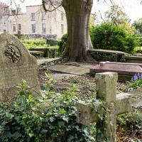
I didn't really set out with a theme of flowers and gardens in mind for this walk. I just fancied heading up to Clifton Village to get lunch. As it turned out, though, Spring was springing, so a minor theme emerged as I started off with the graveyard flowers of Hope Chapel and wandered up to see the beginnings of the new wildflower garden at Clifton Hill Meadow.
...doesn't sound like the kind of man who would appreciate the somewhat lax attitude his gravestone is taking to uprightness.
An Evening Wander to the Gallows
06 Apr 2021
I'd originally intended just to pop up to the area around Alma Road, where I'd missed a few streets on earlier wanders. It was such a nice evening, though, I decided to extend my walk up to the very top of Pembroke Road, just outside my one mile radius, to take a few snaps of something intriguing I'd found in my researches.
I've driven, walked and jogged past the little triangle of land at the top of Pembroke road a great deal in my time in Bristol, but I didn't know that it used to be the site of a gibbet, in fact that the road itself there used to be called Gallows Acre Lane. According to the Durdham Down history trail, by Francis Greenacre (an excellent name for a Downs researcher!) among other sources:
...it was below this quarry near the top of Pembroke Road, once called Gallows Acre Lane, that a gibbet stood. It was sometimes occupied by those who had committed robberies on the Downs and was last used in 1783 to hang Shenkin Protheroe for the murder of a drover. Stories quickly spread that he descended from the gibbet at midnight every night and stalked through Clifton. Such was the alarm that his body was cut down and buried.
Also very close to this little triangle of land was one of the gates of the extensive turnpike system...
Anyway. Along the way I encountered a wooden tortoise and a real squirrel, among other things. It was a good walk, and more light in the evenings means I can move my wanders out of the ticking countdown clock of work lunch-hours and be a bit more leisurely.
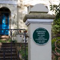
The Guardian's obit calls her "a saviour of historic Bristol".
At that time, there were 400 buildings in the city earmarked for demolition but Dorothy, who was instrumental in their listing, managed to save most of them, including the 18th-century Brunswick Square in St Paul's, via many public inquiries. Among her later successes, Dorothy helped to save the Clifton lido – dating from 1849, it is one of the oldest surviving lidos in Britain – which nearly succumbed to a developer's bulldozer in the late 1990s.
Very Local
06 Nov 2020
It's surprisingly easy to overlook the giant Wesleyan Grenville Chapel—now converted into flats—if you've lived here a while. Other sights that seem to slip from my memory include the modest Ashton Avenue, a tidy terrace of little houses on a road that presumably gave its name to the Ashton Avenue bridge.
Little Clifton Village Details
09 Nov 2020
I like The Paragon as a terrace, especially the bowed porches. On the other side of the road, a house attic has a stone lion surrounded by rocaille leaves, according to its listing.
I also love the detail of the arrows in the wrought iron of The Mall's balconies. Today I discovered Westfield place, a road I'd never encountered that runs up to the rear of the Coronation Tap. (It's a famous local cider pub, but I've only been in a couple of times. I'm more of a beer man.)
Doors and walls, closed paths and chalk
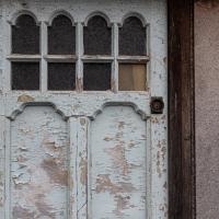
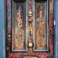
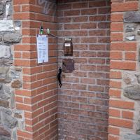
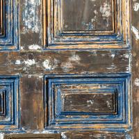
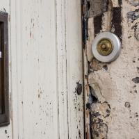
11 Nov 2020
I'd love to walk the Chocolate Path again at some point, but it's been closed since it started falling into the river. Still, on this wander to get a coffee I walked down a road I'd not normally use and found a door dressed up as a wall and another door that had been bricked up for real. Odd.
I also found a lovely bit of art on one of the Cumberland Piazza pillars on my way home.
Clifton Village: Jesus and the Tympanum
12 Nov 2020
My goal is walk down every public road within a mile of me; sometimes it's not easy to tell what's public. I've passed the turning for Cornwallis Grove a thousand times, but never had a reason to venture down it, and although the street signs at the end seem to be council-deployed and I didn't spot any "private" signs, it's a gated road and definitely feels private.
Gathering all the white middle-class privilege I could muster, I wandered down and was rewarded with the sight of a Victorian pump, a statue of Jesus, and from the end of the road, a view of a private garden that once belonged to a private girls' school.
The Cornwallis House history page says:
In the early 20th century the house, together with Grove House, became a Catholic school, St Joseph’s High School for Girls. The Congregation of La Retraite took over the school in 1924, with the nuns living in Grove House while the schoolrooms were in Cornwallis House. The headmistress was Mother St Paul de la Croix (Sister Paula Yerby). By the 1970s La Retraite High School had around 700 pupils.
It closed in 1982 and the building was bought by Pearce Homes Ltd (now part of Crest Nicholson) who developed it into 21 flats. Grove House next door was bought by the Bristol Cancer Help Centre, and was later converted into flats in 2007.
Jaunt to a Closed Coffee Shop
17 Nov 2020
A fruitless wander, as Spoke and Stringer (who I thought might do a decent flat white) were closed, and the only other harbourside inlet offering were a bit too busy to wait at, especially as I'd spent some time wandering some of the convolutions of Rownham Mead. This last congeries of dull alleyways and brown-painted garages was at least somewhere I've never been before, in parts.
...which is also the name of the new hipster coffee place around the corner. Or am I bluffing?
Clifton Village Mini Wander
20 Nov 2020
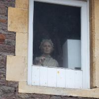
Just a quick wander up the hill to get a flat white from Twelve. I really enjoyed the spooky mannequin (?) in the window.
Bedmo and Ashton Court
21 Nov 2020
A rather more wide-ranging weekend wander with Sarah and Vik, taking in some mock Tudor bits of Bedmo (I should note that I've subsequently been corrected to "Bemmie", but I'm an outsider and have been calling it "Bedmo" for short for decades...), a chunk of Ashton, a path up Rownham Hill called Dead Badger's Bottom(!), The Ashton Court estate, a bit of the UWE campus at Bower Ashton, and some of the Festival Way path.