Tagged: parallel
Rabbits, bad pedestrian signage and good coffee
13 Nov 2020
A quick trip with the aim of finding a better way to Greville Smyth park and a good coffee. Sadly I was stymied yet again with the former—it turns out that you do apparently have to take a strange loop around the houses (or at least around the roads) to get to Greville Smyth any way other than my normal route, unless you're prepared to vault some railings. It may be that the disused steps from where the skater kids hang out to the flyover above might once have led to a shorter route, but it's hard to tell. The geography in the area has always confused me.
On the plus side, Rich, who runs Hopper Coffee from a Piaggio Ape does a great flat white and often has a good sign. (I collect cafe signs...)
Little Victories
16 Feb 2021
There's a dearth of my favourite coffee places on a Monday and Tuesday at the moment. Both Twelve and Imagine That are closed on Monday and Tuesday, and Rich from Hopper Coffee doesn't seem to have come back from Christmas break. Today I pushed on a bit further than normal around the harbour and got to Little Victories, the always-reliable sister cafe to Small Street Espresso, based at Wapping Wharf. Along the way I saw graffiti, my second reference to one of Bristol's twin cities in two days, and a rather sleek little boat outside Rolt's Boat Yard.
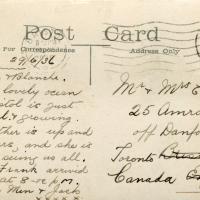
I bought a vintage post card from eBay this week. It's a well-known photo of the Hotwells landing stage, showing what's likely to be a P&A Campbell paddle steamer moored there. (Just yesterday I snapped a photo of their buoy on display at Underfall Yard with its information sign.) It was posted from here to Canada in 1936, and has now returned via a presumably quite circuitous route.
Local journalist Maurice Fells (really local—I could probably hit his house with a well-flung teacake from here) notes in The A-Z of Curious Bristol (£) that:
For tens of thousands of people, the pier at Hotwells was the starting point of their day trip as they boarded steamers with names like Glen Avon, Glen Usk and Britannia. The salty tang of the sea was never far away as the steamers headed for Ilfracombe, Weston-super-Mare, Clevedon and Portishead on the Devon and Somerset coast and Barry, Porthcawl and Tenby in South Wales.
The landing stage is long-abandoned. A variety of economic issues, including fuel prices, the increasing prevalence of the motor car, the construction of the Severn Crossing giving easier access to Wales, and the collapse of Clevedon Pier during safety testing in 1970, which prevented larger pleasure boats from stopping at the resort, all led to dwindling trade.
I went to have a poke about there today, not staying for long as it's a cold day and the wind was biting. I couldn't reproduce the postcard's view—you'd need to risk life, limb and presumably a trespass prosecution—but I did try to judge the rough viewpoint and angle of the photo by lining up with Rock House, the Colonnade and the Suspension Bridge and snapped a photo looking back to where the original photographer would have stood on the pontoon.
This Bristol City Docks history page has many good photos of the landing stage and the nearby Port and Pier Railway line (whose tunnel I was in the other day) and the Hotwells Halt railway station, which was just the other side of the suspension bridge from here.
Mardyke then and Now
18 Mar 2021
Reproducing historical photos seems to be a developing interest for me. On today's wander I just went for my normal coffee at Imagine That, but along the way I stopped at Baltic Wharf (the modern housing estate; historically-speaking, I was probably in between Canada Wharf and Gefle Wharf—about here, in fact) to reproduce a 1930s photo of the Mardyke area from the Tarring collection.
Mardyke, from what I can work out, means "a ditch along the margins". Before my researches, I only really knew the name from the Mardyke pub, a big place on the Hotwell Road. Everyone knows the Mardyke, partly because of its size and signage, but I've only been in once or twice, too long ago to remember much of what it was like. However, the wharf there used to be known as Mardyke Wharf, and the area in general as Mardyke. (I just found an 1826 painting by Thomas Leeson Rowbotham of "Mardyke seen from near Hilhouse's Dock, showing the 'Clifton Ark' floating chapel" that shows the area before much development had happened, incidentally, and now I feel like I need to find out a bit more about the floating chapel...)
I enjoyed snapping the "after" photo; the process involved moving a group of swans out of the place I needed to stand to get the photo; luckily I've started carrying waterfowl food along with my on my harbourside jaunts, so I could use bribery rather than a more confrontational approach. Not sure I'd fancy my chances against a swan, though I did once team up with another passerby to shoo a recalcitrant one off the Redcliffe bascule bridge so a busful of commuters could continue their journey to work...
Showing both the Clifton Industrial School on the Hotwell Road, and the Clifton National Schools building on the hill above.
(via the Loxton Collection from Bristol Libraries on Flickr.)
Man on a Mission
17 Apr 2021
I went rather outside my area today, as I went to pick something up from the Warhammer shop on Wine Street (Games Workshop as-was, and before that I think perhaps a rare retail outlet for Her Majesty's Stationery Office? I may be mis-remembering...) Anyway, a friend of mine wanted something picking up and posting to him, so I figured I'd knock some streets off my list along the way.
I first headed for the St George's Road area, walking down the narrow Brandon Steps and finding some strange wall art on Brandon Steep, then headed to the Old City via Zed Alley. The Warhammer shop visit was friendly and efficient, and, mission accomplished, I treated myself to a sausage roll and a flat white from Spicer + Cole, to take away and eat in Queen Square with its current decoration of hearts. I finished off with a detour up Park Street, looking out for St John's Conduit markers, before finally crossing Brandon Hill on the way home.
Quite a long wander, all told, and I'm a bit knackered today...
Leftovers with Lisa
01 May 2021
I didn't get to all the little leftover streets around the northeastern part of my area in today's wander, but I definitely knocked a few off the list, plus Lisa and I enjoyed the walk, and didn't get rained on too badly. We spotted the hotting-up of Wisteria season, checked out Birdcage Walk (both old and new), ventured onto the wrong side of the tracks1 and generally enjoyed the architecture.
1 Well, technically we probably shouldn't have been on the grounds of those retirement flats, but nobody started chasing us around the garden with a Zimmer frame
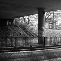
Victoria Square Underpass
06 May 2021
I'm meant to be taking a little break from this project, but in my Victoria Square researches after my last walk I noticed a curiosity I wanted to investigate. The community layer on Know Your Place has a single photograph captioned, "The remains of an 'underpass' in Victoria Square".
Looking back through the maps, I could see that there really did used to be an underpass across what used to be Birdcage Walk. I can only guess that it was there to join the two halves of the square's private garden that used to be separated by tall railings that were taken away during WWII. Maybe it was a landscaping curiosity, maybe it was just to save them having to un-lock and re-lock two gates and risk mixing with the hoi polloi on the public path in the middle...
Anyway. Intrigued, I popped up to Clifton Village this lunchtime for a post-voting coffee, and on the way examined the remains of the underpass—still there, but only if you know what you're looking for, I'd say—and also visited a tiny little road with a cottage and a townhouse I'd never seen before, just off Clifton Hill, and got distracted by wandering the little garden with the war memorial in St Andrew's churchyard just because the gate happened to be open.
EDIT: Aha! Found this snippet when I was researching something completely different, of course. From the ever-helpful CHIS website:
When there were railings all round the garden and down the central path, in order that the children could play together in either garden there was a tunnel for them to go through. This was filled in during the 1970s but almost at the south east end of the path if one looks over the low wall the top of the arches can still be seen.

Before WWII, you can see why one might have wanted an underpass to cross between the two halves of the private garden on either side of Birdcage Walk.
Sequel Injection
07 May 2021
I saw this tweet the other day and started thinking of my second Covid-19 vaccination as my "Sequel Injection" (to a geek, it's funny. You'll have to take my word for it.) Whatever you call it, this morning I went and got it.
It was in the same place I got my initial injection—my left arm! No, okay, it was at the Clifton College Prep School. I didn't take any photos of the event itself; the NHS production line is so efficient you barely have time to do anything else, even if the privacy of other patients wasn't a factor.
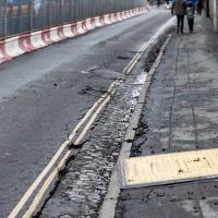
Along the way I mused at all the road resurfacing going on in Clifton, and also discovered a secret (okay, not-well-known and possibly slightly trespassey) way into Canynge Square, and on the way back I knocked off a few streets from my "leftovers list" of north-east Clifton. I've got much of Clifton done now, with the only obvious "to dos" on the east side of Whiteladies Road...
It was quite a long walk, and I'm feeling pretty tired now, though that might be the effects of the jab too, I suppose. Anyway. Tomorrow and Monday I'm walking outside Bristol, I think, and I imagine my feet will need some recovery time on Sunday, so it might be a while before I post another Wander.
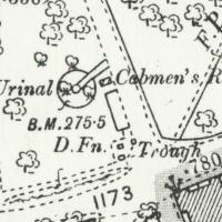
Looking at the old OS maps, it seems this must have been where all the local cabbies hung out. The Cabmen's Rest has a urinal, drinking fountain, and horse trough, all on this little corner. Perhaps the little wall marks the edge of an old shelter; there's a box on the map there but it doesn't give much away.
Ther's a little shelter/bandstand-looking thing in the background of a few historic photos from the area like this one of a horsedrawn omnibus but it's hard to tell what's where.
Green Squares and Secret Gardens
31 Jul 2021
At the end of July I went to have a look around some of the private gardens opened up by the annual Green Squares and Secret Gardens event. Sadly it was compressed into a single day this year, for various Covid-related reasons, it seems, so I didn't get to poke around too many places. I went to:
- A talk by the oldest resident of Victoria Square
- The St Vincent's Rocks Hotel garden
- The Paragon garden
- Cornwallis Crescent gardens, both east and west
- The Polygon garden
And snapped a few things in between, too. It was a lovely day—a bit too hot, if anything—and it was interesting to get into a few places I'd only ever seen from the outside, especially The Paragon and Cornwallis gardens, which are the least visible to passing strangers of all of them.
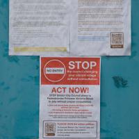
It's a little tamer now than it was back when anti-residents' parking zone protesters drove a tank through the city to deliver their petition. This one's about an experiment to pedestrianise Princess Victoria Street.
Won't make any difference to me one way or the other, really; I just walk up to Clifton Village for my shopping. Or, quite often, in completely the other direction, to North Street in Bedminster. I like both areas for shopping, and it's good to live close enough to either to get there on foot.
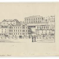
I recently indulged myself by buying a little piece of history. I've mentioned Samuel Loxton and featured and linked to his drawings before, often in the eminently browsable Loxton Collection albums that Bristol Libraries has on Flickr. So when I saw a Loxton drawing of Hotwells pop up on eBay, I decided to get myself a little treat.
I don't think there's any Loxton drawing that features the road I actually live in—it's not very visible from anywhere else, not being one of these Clifton terraces that's perched at the top of a hill, or anything like that, and it's invisible in most views of the area. However, this Loxton drawing, Hotwells, Looking across the river from near the Clifton Bridge station, is probably the closest near-miss I've seen.
I decided to wander out one morning and see if I could reproduce the picture, and also take a photo or two of what's now become of the Clifton Bridge Station, which is still just about discernible in places.
(Then on an even stranger whim I decided to check out a possible little cut-through from Cumberland Road to the harbourside I'd been eyeing up on my commute to work, so walked to Wapping Wharf for a croissant via this potential new route, but that bit's not quite as interesting...)
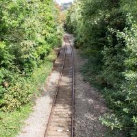
You can just about make out the platform still, there on the left. There used to be a second line and an eastern platform, too.
Clifton Bridge Railway Station was also known as Rownham Station from 1891 to 1910.
It was part of the Port and Pier railyway (as was Hotwells/Clifton station on the north side, nearer my house), opened in 1867, and closed, inevitably, by Beeching, with passenger services stopping in 1964 and freight a year later.
Wikipedia says "Freight trains continued to pass through the station, but their number decreased over time, with the line falling out of regular use from 30 March 1981. The route however was kept intact by British Rail, with occasional freight trains, and in 2002 a single track was relaid to allow rail access to Royal Portbury Dock", so I suppose even the single line we see here is newish.
Adjacent to the station was the New Inn, Rownham, which you can see a bit of in this photo from the Tarring Collection on KYP (or in this Tweet.
People will know the station site as the place where the local police's mounted and dog sections had their headquarters/stables/kennels, though they moved out a couple of years ago, I think.
Although the line is scheduled to return to passenger service as part of MetroWest, the nearest station will still be Temple Meads, so even though there may be passenger trains heading out to Pill and Portishead through here, ten minutes' walk from my house, I'd have to get all the way into town to come back out again, so it would probably be quicker for me to drive. Shame.