Tagged: parallel
I'm afraid that this is a bit of a badly-curated wander, where I mostly just popped out to find out a little of the history of Underfall Yard and poke around the various open workshops, and, in hindsight, really didn't take pictures in any kind of coherent order. So there's a lot of pictures, but they don't really tell the story that, in hindsight, I seem to have been trying to tell, of the unusual electrical substation in Avon Crescent, the Bristol Electricity that predates the National Grid but is still in use, the history of the hydraulic power house... It's a bit of a mess.
But I suppose sometimes these wanders—always chronologically presented in the order I walked and took photos—simply will sometimes be a bit of a mess. Let's hope you still get something out of it, anyway...
I've mentioned before the suggestion (apparently from Pete Wills, senior electrical engineer) that this building is haunted by the ghost of a worker who fell from the roof into the building but whose body was never found... Maybe I should have waited until Hallowe'en to feature the substation!
Recreating a Loxton Drawing on a Lunchtime Jaunt
05 Nov 2021
I did do a much longer wander earlier in the week, but that'll take me some time to process (and cast a plethora of photos into the "out-takes" pile!) In the meantime, here's my lunchtime jaunt, taken to give myself a break from doing the company bookkeeping to send to my accountant so the taxman doesn't sling me in chokey.
I've recently bought a slightly creased secondhand copy of Redcliffe Press's 1992 collection of Samuel Loxton drawings, Loxton's Bristol: The city's Edwardian years in black and white. It's a nice selection of Bristol Library's collection of the drawings. I'd noticed a drawing of 25 Royal York Crescent, a house I pass quite often, so I thought I'd wander up the crescent on the way to pick up some lunch and try to reproduce it.
On the way back I took a few photos of Clifton Hill Bank as the crowdfunder to make quite a lot of it into a wildflower meadow has just hit its target, so I figured some "before" shots might be a good investment for the future...
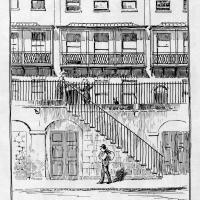
Loxton drawing from Bristol Library collection via Loxton's Bristol, Redcliffe Press, 1995 ISBN 1 872971 86 5.
I went out simply wanting to knock off the very last little unwalked section of Clanage Road, over by Bower Ashton, which has been annoying me for a while as it's quite close by and I've walked the other bits of it several times. So, my plan was to nip over to Greville Smyth Park via a slightly unusual route to wander Clanage Road and tick it off.
Along the way, though, I inevitably got a bit distracted. I took a few photos of Stork House, a grand Hotwell Road building that's recently been done up a bit (I imagine it's student lets, though I'm not sure) and which I found a reference to in a book about the Port Railway and Pier the other week, and also tried to match up a historical photo of Hotwells before the Cumberland Basin Flyover System laid it waste, which included some interesting markers I'll have to do a bit more digging into...
A Constitutional to Burwalls and Back
21 Dec 2021
The recent lack of posts here is mostly due to my feeling very run down following having a couple of wisdom teeth extracted. Having had an emergency appointment yesterday1, hopefully I'll be on the mend now, though it does mean I'm on the kind of antibiotics where you can't touch alcohol for the whole of the Christmas period. I have tried to keep myself a little distracted from the pain by working on the nuts and bolts of this website—you should notice that the front page loads rather faster now than it used to, and that there's a shiny new statistics page that I'll probably be continuing to work on. Oh, and you should find that the tags below the photos are now clickable and will take you to a page of all other wanders that have photos with the same tag.
Today I felt like I needed to drag myself out of the house, but I didn't want to go too far, and I needed to get to the Post Office up in Clifton Village to post a Christmas card (spoiler for my parents: it's going to be late. Sorry.) As luck would have it, idly looking at the map I spotted that I'd missed off a section of Burwalls Road in the past, and that's basically one of the long-ways-round to Clifton Village, crossing the river to Rownham and walking up the hill on the Somerset side before coming back across the Suspension Bridge.
As I was heading for Burwalls Road I decided to make Burwalls itself the focal point of the walk, but unfortunately the mansion grounds are private and the place is hard to snap. Still, at least it gave me a destination. Burwalls was the mansion built by Bristol press magnate Joseph Leech, who I've mentioned before after buying a vintage book he wrote on a previous wander. There's a good article about the house on House and Heritage which has some photos from angles I couldn't ever get to. (Well, maybe with a drone, but it seems like the kind of area where they may be kitted out for clay pigeon shooting, so I probably wouldn't risk it.)
1 My dentist admitted that she probably needed to keep her internal monologue a bit more internal after we started the appointment with her staring into my mouth and immediately saying, "oh, *that's* weird." These are words one doesn't want to hear from a medical professional.
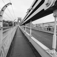
Most every time I cross the bridge, I remember one of the first times I walked over it, back in the late 1990s or early 2000s, when some wag—possibly even Banksy, who knows?—had painted a sign on the footway about here: a rectangle of yellow caution stripes containing the words "WARNING. CONCEALED TRAPDOORS IN OPERATION".
I noticed I had a few things on my "potential wanders" list that could all be done relatively close to home, and in a fairly straight line, so I set off at lunchtime to recreate a photo of a now-defunct pub, wander behind a Spar (which turned out to be more interesting than I'd expected, but I admit it's a low bar) and spend some time browsing in Dreadnought Books before coming home via a coffee from Spoke & Stringer, a little diversion up Gasworks Lane and a tiny bit of the Rownham Mead estate I'd somehow previously skipped.
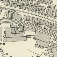
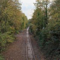
On Know Your Place you can check out old maps of Bristol. Sadly there doesn't seem to be an easy way of linking to a particular map/location. Still, here's a little screenshot of the 1898-1939 layer. These tracks are still there on the later 1949 map, so at least this section survived the war, I think.
Having checked Wikipedia I think this section, which ran from Canons Marsh to Ashton Avenue Bridge and then on to the south was created in 1906, and closed in 1965.
This map fragment will be © Ordnance Survey.
I've been pretty awful at reading so far this year, apparently averaging about one book per month. That's a far cry from 2019, say, where I got through 41 books in the year. Today's wander was prompted by my rubbish reading, as I needed to go hand back some books to the library, because I'd managed to renew them so many times that I hit the limit on renewals. Oops. Several of them were still unread.
So, off to the Central Library for me, tail between my legs. On the way there I did my best to recreate a historical photo of Dowry Square; while I was in the area I walked under the adjacent Norman arch and poked around behind the Cathedral, and I also had a little diversion to the city centre and came back along the south side of the river, hitting some trouble with the lock gates as I finally crossed the harbour back towards home.
This was rather more a "memo to self" so I'd be able to find the album (for this exhibition was intrinsically linked with Sean Addicott's music) on Spotify.
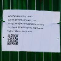
According to the website this is "a research site and artwork to help us think about the future" by Ella Good & Nicki Kent. I'll be interested to go back for another look...