Tagged: historical
Nothing New
02 Dec 2020
This may be the very first time I've gone for a One Mile Matt wander and not actually gone down any new roads, trod any new steps. I just wanted a coffee, frankly, so I went the same old way to Imagine That in the marina and back again.
Leigh Woods Walk
14 Mar 2021
An enormous walk today, or at least it felt enormous. My feet are sore, anyway. I started off recreating a couple of local historical photos in Hotwells, but then headed for my traditional walk along the towpath in the Avon Gorge to the far extreme of Leigh Woods, up and through the woods to the height of the Suspension Bridge, finally crossing into Clifton Village for a well-deserved vanilla latte.
I say "traditional" because this used to be a very regular route for me, first walking, years and years ago, and later jogging—this route combined with a circuit of the Downs on the other side used to be my way of making sure I was fit to do a half-marathon (I did six of them in total, between 2010 and 2014).
I miss the routine of this walk, even though it's a long way and it used to pretty much wipe me out when I did it—I'd come back home and collapse and do very little for the rest of the day. But perhaps that's what Sundays are for, and I should try to remember that.
Doing this walk regularly was quite a meditative experience. Not so much of that today, but once I got to the further extreme of the towpath, where the roar of the Portway traffic on the other side of the river dwindles and I turned into Leigh Woods to climb ever closer to birdsong and further from rushing cars, I did seem to recapture a little of the feeling of previous walks. (I would say my mind cleared, but I was mentally singing along to Life Without Buildings' The Leanover for most of the wander. There are worse songs to have stuck in one's head, though; it's a great track...)
Anyway. Apparently the walk made me more likely to ramble in words, too. I'll stop now :)
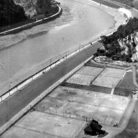
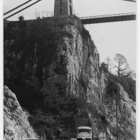
Via KYP Bristol/The Tarring Collection. ca. 1930.
The Tarring Collection is a grand set of images of Bristol taken by Herbert Frank Tarring, who worked as a Quantity Surveyor for Bristol Corporation in the 1930s.
Lunchtime Reproduction (of an old photo...)
17 Jan 2022
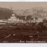
This was basically the quick lunchtime jaunt I tried to do at the beginning of January, only this time I actually managed to get to roughly the viewpoint I'd been hoping for to recreate a historical photo of the Bristol International Exhibition.
I did this walk about a month ago, but I've been a bit poorly and not really up to doing much in my spare time, and it's taken me this long to even face processing even these few photos. Hopefully normal service will be resumed at some point and I can carry on trying to walk any roads and paths that I need to do to make this project feel complete...
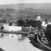
From Bristol's Lost City, by Clive Burlton, available from Bristol Books; photograph from the author's own collection.
(And extra credit goes to my parents for buying me the book for my birthday! Thanks!)
The Bristol International Exhibition site, presumably around 1914 or not long after. You can see the Rownham Ferry in use, too. I still find it pretty amazing that there used to be a busy ferry and a significant railway station on this little scrap of land that I just used to know as the grassy bit at the start of the towpath, let alone a replica of Bristol Castle!
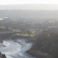
Unlike my last attempt I successfully managed to get somewhere near the vantage point of the historic photo this time...
I should probably have tried to get it at high tide to make it a bit more comparable, but you can't have everything.
You can see the White City Allotments—those glints of light toward the middle are mostly reflections from greenhouses—where the "White City" of the Exhibition used to stand. There's still a glimpse or two of the railway line to Portishead to be seen, too, along with a vestige of the Rownham Ferry slipway.
Mostly though it's the modern things that stand out—the long line of flats along Paxton Drive, the curve of Brunel Way across the river, and the roof of Ashton Gate Stadium...
I was just about starting to feel better—the antibiotics seemed to have kicked in for my dental issues, and it had been some days since I'd left the house, and I was at last starting to get itchy feet. So, a wander. But where? Well, there were a few industrial bits near Winterstoke Road in the Ashton/Ashton Vale areas of Bristol that needed walking. I knew they were likely to be quite, well, unattractive, frankly. So why not do them while I wasn't feeling exactly 100% myself? Maybe it would fit my mood. Hopefully you're also in the mood for a bit of post-industrial wasteland, for that's what some of this feels like...
Then, at the last minute, I thought again about the Bristol International Exhibition—I've got a book about it on the way now—and that gave me another goal, which could just about be said to be in the same direction, and I decided to walk significantly further than my normal 1-mile limit and try recreating another historical photo...
Sadly I don't know much about the Ashton area; it's just on the edges of my mile and I rarely have cause to go there. It's brimming with history, I'm sure: the whole South Bristol area rapidly developed from farmland to coal mines to factories to its current interesting mixture of suburbs and industrial work over the last few hundred years. As a more working class area less attention was paid to it by historians, at least historically-speaking, than the Georgian heights of Clifton, and much of it has been knocked down and reinvented rather than listed and preserved. I see here and there some of this lack is being addressed, but I'm afraid I'll be very light on the history myself on this wander, as most of my usual sources aren't throwing up their normal reams of information as when I point them at Clifton, Hotwells or the old city.
Source: Bristol Archives, Vaughan Collection.
Here we look, apparently from Bedminster Down, towards the "white city", the Bristol International Exhibition buildings of 1914.
This is the photo I've trooped all this way to reproduce. Have I managed to find the right spot?
The more I research it, the more I find that Hotwells had far better transport links back in Victorian and Edwardian times than it has today. Along with buses that went to more useful places than the City Centre, there were trams, the funicular up to Clifton, the landing stage for paddle steamer services and two railway stations all within easy walking distance of me.
Today I took a day off work as preparation for doing the bookkeeping for my tax return1, and took a wander along to the site of what would have been my nearest station, Hotwells (or Clifton, as it started out in life), nestled in the shadow of the suspension bridge, the Bristol terminus of the Bristol Port Railway and Pier.
From there I wandered down the Portway, following the original line, until I got to the area around Sneyd Park Junction, where the tunnel from the slightly later Clifton Extension Railway joined up with this originally-isolated BPR line. Then I headed up to Clifton through the "goat gully" at Walcombe Slade, seeing the few above-ground bits of evidence of the tunnel (which is still in regular use) along the way.
It was a lovely day, and a good walk, and it was interesting to daydream of the times when I could have walked a few minutes from my flat down to Dowry Parade, caught a short tram ride to Hotwells Stations, and then headed from there to Avonmouth, perhaps even to board a transatlantic passenger service. The completion of the Clifton Extension Railway that linked the Avonmouth station with Temple Meads made relatively direct transatlantic travel from London via Bristol possible, with passengers travelling up from Paddington to Temple Meads, on to Avonmouth on the Clifton Extension Railway and Port Railway and Pier line, then perhaps catching a Cambpell's paddle steamer—which sometimes acted as tenders for large steamers—to a larger ship that was headed out for Canada, say.
1 I've learned that the best approach is to take two days off and deliberately do something that's not my bookkeeping on the first day, as otherwise I just inevitably end up procrastinating and feeling guilty on the first day no matter what. I have an odd brain, but at least I'm learning strategies for dealing with its strange ways as I get older...
2 Information mostly gleaned from Colin Maggs' The Bristol Port Railway & Pier and the Clifton Extension Railway, The Oakwood Press, 1975.
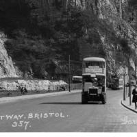
Here we see the Portway road, presumably fairly shiny and new, after many, many things, including the railway line from Hotwells to Sea Mills, were removed to make way for it. As you can see, they've done a splendid job of redeveloping the space where the station was into a little mini-park area, back in the day when the traffic wasn't a constant rush of noise and fumes and you didn't have to scamper across like you were playing a game of Frogger. It might well have been a pleasant place to sit. It certainly wouldn't be now.
Also, guess what there is fencing in the park area? Yes, some nice iron railings. I have no idea whether these are same ones I found—today's seem in surprisingly good nick considering this photo would have likely been taken almost a hundred years ago, and also how many railings were torn up during WWII.
This photo was taken before the war, as you can see a tram still running in the background—a Luftwaffe bomb took the tram system down in 1941 and it was never replaced. It also was obviously taken after 1926, as the Portway opened to traffic on 2 July 1926, having cost £800,000 to build, about £47m in today's money. So, that fixes it to a 15-year period, I think, but I'm not enough of a historian to be able to pin it down further.
Bottom section of the postcard. I like the way there's a bus and a tram in it, but I'd quite like the bus not to be there so we can see the whole of the former station site. Motion blur makes it hard to figure out the bus and tram details.
