Tagged: et
Very Brief Hotwells Wander
18 Feb 2021
Really just a quick loop of the Cumberland Basin. I was going to go further, and it was a nice early spring day, but I hadn't slept that well and I wasn't really in the mood. Ah well. Not every walk is great. At least I got out of the house for a bit.
Towpath Evening
25 Mar 2021
I was honestly just about to do the homework from my oh-so-thrilling ITIL course when my friends Sarah and Vik asked me if I'd like to come out for a wander down the towpath with them. I enjoyed the company, the evening light and the delicate clouds.
Leigh Woods Solo
19 Jun 2021
I hadn't really planned to go out for a wander yesterday; I just got the urge and thought "why not?" (Well, the weather forecast was one possible reason, but I managed to avoid the rain, luckily.)
I wanted to finish off the A369—as it turns out I may still have a small section to go, but I've now walked the bulk of it out to my one-mile radius—and also a few random tracks in Leigh Woods. I'm still not really sure that I'm going to walk them all, especially after discovering today that "the map is not the territory" applies even more in the woods, where one of the marked tracks on the map wasn't really that recognisable as a track in real life... I'm glad I'd programmed the route into the GPS in advance!
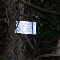
Anyway. A pleasant enough walk, oddly bookended, photographically at least, by unusual vehicles. Leigh Woods was fairly busy, especially the section I'd chosen, which was positively dripping with teenage schoolkids with rah accents muttering opprobrium about the Duke of Edinburgh. I'm presuming the harsh remarks were more about taking part in his award scheme than the late Consort himself, but I didn't eavesdrop enough to be certain...
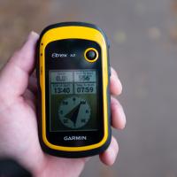
This is what I've been using to record the GPS track for all my walks. It's old-fashioned, but I find it more accurate than the phone, plus it runs off a couple of AA batteries and I only have to replace them every few weeks. Today it wasn't just recording my track, but also guiding me through a pre-planned route. Here it shows me direction, distance and estimated time to my next waypoint.
Mirror Maze
10 Jan 2021
Went for a wander with my friend Lisa—the current lockdown rules seem to be that one local walk for exercise per day with a maximum of one person not in one's "bubble" is fine—up to the University of Bristol area right at the edge of my one-mile perimeter to see the Jeppe Hein Mirror Maze, among other things. On the way we mused about Merchant Venturers, the slave and tobacco trades, and dating in the time of Covid.
To Bedminster
19 Dec 2020
Despite a mild headache, I enjoyed this wander over to Bedminster. The light was lovely, especially toward the end. I always enjoy the view down the streets south of North Street at this time of day/year, with the distant hills backdropping the Victorian terraces.
Bedminster, Ashton, Ashton Court sunset walk
12 Dec 2020
A walk with Sarah focusing on Ashton and the surrounds, taken on a day with really nice light around sunset. Just what I needed.
Rainy Clifton
13 Dec 2020
A long walk around Cliftonwood and Clifton with my friend Lisa, taking in some of the 12 Days of Christmas display at Queens Parade, picking up a take-away coffee from Pinkmans of Park Street, and poking our heads up against the glass of SS Peter and Paul Catholic Cathedral.
Mardyke then and Now
18 Mar 2021
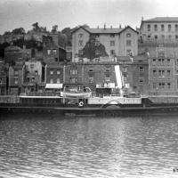
Reproducing historical photos seems to be a developing interest for me. On today's wander I just went for my normal coffee at Imagine That, but along the way I stopped at Baltic Wharf (the modern housing estate; historically-speaking, I was probably in between Canada Wharf and Gefle Wharf—about here, in fact) to reproduce a 1930s photo of the Mardyke area from the Tarring collection.
Mardyke, from what I can work out, means "a ditch along the margins". Before my researches, I only really knew the name from the Mardyke pub, a big place on the Hotwell Road. Everyone knows the Mardyke, partly because of its size and signage, but I've only been in once or twice, too long ago to remember much of what it was like. However, the wharf there used to be known as Mardyke Wharf, and the area in general as Mardyke. (I just found an 1826 painting by Thomas Leeson Rowbotham of "Mardyke seen from near Hilhouse's Dock, showing the 'Clifton Ark' floating chapel" that shows the area before much development had happened, incidentally, and now I feel like I need to find out a bit more about the floating chapel...)
I enjoyed snapping the "after" photo; the process involved moving a group of swans out of the place I needed to stand to get the photo; luckily I've started carrying waterfowl food along with my on my harbourside jaunts, so I could use bribery rather than a more confrontational approach. Not sure I'd fancy my chances against a swan, though I did once team up with another passerby to shoo a recalcitrant one off the Redcliffe bascule bridge so a busful of commuters could continue their journey to work...
Via Know Your Place Bristol/the Tarring Collection.
The Mardyke area—apparently Mardyke means a dyke on the margins, which would make sense for the location—in the 1930s. That's got to be a Campbell paddle steamer from their White Funnel fleet, but I don't know which one. Looks to be a similar configuration to the Princess May, though the paddles look a bit different. In the background, the Mardyke Pub still stands today, but the three largest buildings do not. They are:
Top right: the Clifton National School (there's a Loxton sketch uploaded to this Wander where you can see the name on the front.)
Directly in front and below the Clfiton National School, on the main Hotwell Road: The Clifton Industrial School, Mardyke building.
Standing halfway up the hill, more towards the middle of the picture: the Clifton Industrial School, Church Path Steps building.
Lots of info to be found on the Industrial Schools here:
In addition to their classroom lessons, the boys were employed in tailoring, shoemaking and brush-making, with basket making later added. The boys also assisted with the kitchen, laundry, and house work. In 1870, some additional rooms were rented in the locality for use as an infirmary if required. A School band was established.
I can't find so much on the National School (though apparently the Bristol Archives have some of their records) but the Clifton & Hotwells
Character Appraisal suggest it was built in 1835 and, along with the Industrial School buildings, destroyed during WWII:
A bomb also largely destroyed the Clifton National School and Mardyke House School. The lack of bomb- proof shelters in Clifton led to the Clifton Rocks Railway to be used as shelter, which was prepared for occupation in 1940.
I'm afraid that this is a bit of a badly-curated wander, where I mostly just popped out to find out a little of the history of Underfall Yard and poke around the various open workshops, and, in hindsight, really didn't take pictures in any kind of coherent order. So there's a lot of pictures, but they don't really tell the story that, in hindsight, I seem to have been trying to tell, of the unusual electrical substation in Avon Crescent, the Bristol Electricity that predates the National Grid but is still in use, the history of the hydraulic power house... It's a bit of a mess.
But I suppose sometimes these wanders—always chronologically presented in the order I walked and took photos—simply will sometimes be a bit of a mess. Let's hope you still get something out of it, anyway...
A Morning of Research and a Cafe in a Castle
25 Sep 2021
I needed to pop to the library, as they'd kindly dug a book out of the reserve store at the B Bond warehouse for me and emailed me to let me know it was ready. So, I took a little trip to town, straight down the Hotwell Road, and spent a few hours reading before stretching my legs with a walk to a new cafe in the actual castle (or remnants thereof, anyway) of Castle Park, before heading back home down the other side of the harbour. As well as books and coffee, I bumped into a remote-controlled pirate ship, which isn't something you see every day, even in Bristol.
This place has already garnered several good reviews from locals on Nextdoor and Google Reviews. I must try it at some point.
