Tagged: air
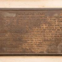
I got interested in Bristol's medieval water supplies after poking around near Jacobs Wells Road and Brandon Hill. It was during that research I found out about a pipe that's still there today, and, as far as I know, still actually functioning, that was originally commissioned by Carmelite monks in the 13th century. They wanted a supply of spring water from Brandon Hill to their priory on the site of what's now the Bristol Beacon—Colston Hall, as-was. It was created around 1267, and later, in 1376, extended generously with an extra "feather" pipe to St John's On The Wall, giving the pipework its modern name of "St John's Conduit".
St John's on the Wall is still there, guarding the remaining city gate at the end of Broad Street, and the outlet tap area was recently refurbished. It doesn't run continuously now, like it did when I first moved to Bristol and worked at the end of Broad Street, in the Everard Building, but I believe the pipe still functions. One day I'd like to see that tap running...
There are a few links on the web about the pipe, but by far the best thing to do is to watch this short and fascinating 1970s TV documentary called The Hidden Source, which has some footage of the actual pipe and also lots of fantastic general footage of Bristol in the seventies.
On my walk today I was actually just going to the building society in town, but I decided to trace some of the route of the Carmelite pipe, including visiting streets it runs under, like Park Street, Christmas Street, and, of course, Pipe Lane. I also went a bit out of my way to check out St James' Priory, the oldest building in Bristol, seeing as it was just around the corner from the building society.
There are far too many pictures from this walk, and my feet are now quite sore, because it was a long one. But I enjoyed it.
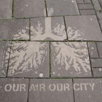
Clever: stencil out the pavement, then pressure-wash it, to make your point by highlighting the discolouration that's partly caused by airborne particulate pollution.
Rainy Clifton
13 Dec 2020
A long walk around Cliftonwood and Clifton with my friend Lisa, taking in some of the 12 Days of Christmas display at Queens Parade, picking up a take-away coffee from Pinkmans of Park Street, and poking our heads up against the glass of SS Peter and Paul Catholic Cathedral.
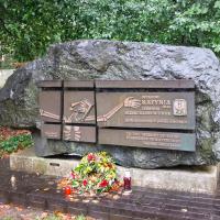
"The Katyn massacre was a series of mass executions of nearly 22,000 Polish military officers and intelligentsia carried out by the Soviet Union, specifically the NKVD ("People's Commissariat for Internal Affairs", the Soviet secret police) in April and May 1940. Though the killings also occurred in the Kalinin and Kharkiv prisons and elsewhere, the massacre is named after the Katyn Forest, where some of the mass graves were first discovered." — Wikipedia
I'm in the habit of going over to the Tobacco Factory Market on a Sunday. I think I've walked all the routes around that way, but as a Plimsoll Bridge swing let me cross the road to the far side of Brunel Way on my return journey and I took a couple of photos of the brownfield development at the old Ashton Gate Depot site I thought I'd call it a Wander and pop some photos up.
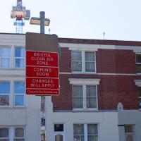
The Clean Air Zone is being introduced later this year (currently they say 28 November 2022, but I think it's already been delayed twice.)
The scheme will see charges instituted for certain vehicles entering parts of the city, especially older diesel cars. This is to encourage people to change these older cars or find alternative routes or modes of transport. Apparently there are grants and loans available for upgrades on offer to private citizens and businesses.
This should only have positive effects for me, as I live just inside the zone, and I drive a recentish petrol car with an efficient and not-so-pollutey engine. In a perfect world, therefore, this scheme means my area might eventually start meeting the government's standards for air quality. This Bristol 24/7 article has some good info, including an estimate that there are currently 300 premature deaths per year from traffic-related air pollution in the proposed Bristol zone.
I was just about starting to feel better—the antibiotics seemed to have kicked in for my dental issues, and it had been some days since I'd left the house, and I was at last starting to get itchy feet. So, a wander. But where? Well, there were a few industrial bits near Winterstoke Road in the Ashton/Ashton Vale areas of Bristol that needed walking. I knew they were likely to be quite, well, unattractive, frankly. So why not do them while I wasn't feeling exactly 100% myself? Maybe it would fit my mood. Hopefully you're also in the mood for a bit of post-industrial wasteland, for that's what some of this feels like...
Then, at the last minute, I thought again about the Bristol International Exhibition—I've got a book about it on the way now—and that gave me another goal, which could just about be said to be in the same direction, and I decided to walk significantly further than my normal 1-mile limit and try recreating another historical photo...
Sadly I don't know much about the Ashton area; it's just on the edges of my mile and I rarely have cause to go there. It's brimming with history, I'm sure: the whole South Bristol area rapidly developed from farmland to coal mines to factories to its current interesting mixture of suburbs and industrial work over the last few hundred years. As a more working class area less attention was paid to it by historians, at least historically-speaking, than the Georgian heights of Clifton, and much of it has been knocked down and reinvented rather than listed and preserved. I see here and there some of this lack is being addressed, but I'm afraid I'll be very light on the history myself on this wander, as most of my usual sources aren't throwing up their normal reams of information as when I point them at Clifton, Hotwells or the old city.


