Tagged: thin
Prince's Lane
06 Jan 2021
The International Grotto Directory website says:
Prince’s Lane might have been one of the original ancient tracks from Hotwells to Clifton, in the Avon Gorge. The site later formed part of Rownham Woods which comprised some thirteen acres. By the end of the 18th century and the early 19th century, the Society of Merchant Venturers granted to Samuel Powell a building lease, for The Colonnade (1786), St. Vincent’s Parade (1790), Prince’s Buildings (1796), and Rock House. Rock House is generally considered to be the oldest surviving building associated with the Hotwell (see Chapter 20). John Power conveyed part of the woods to William Watts for the construction of Windsor Terrace (1790-1808).
The above development of the Avon Gorge cleared Rownham Woods, and created a triangle of land on the north side of the gorge, that became enclosed as a result, by Mansion Houses, whose garden walls all entered on to Prince’s Lane. The Lane started at the bottom of the gorge, at the base rock of Windsor Terrace, and came out half way up Sion Hill. It is clearly shown as a public footpath, dotted with trees, in Ashmead’s map of 1828. Some of the gardens were quite steep in parts and therefore, had to be terraced, because of the gradient of the gorge.
I've passed Prince's Lane literally thousands of times in my life, every time I've walked past the Avon Gorge Hotel, which itself started (in 1898) as the Grand Clifton Spa and Hydropathic Institution and pumped water up from the Hot Well for its hydropathic treatments. I've never actually ventured down it until today, or at least nothing like as far down it as I did this afternoon—I may have poked my head around the back of the hotel to see the original pump rooms at some point in the past.
This was a great wander, though it does very much feel like a private road, and frankly I may have been pushing my luck a bit by winding my way between the astoundingly big back gardens of the houses of some presumably very wealthy Cliftonites, but I felt vaguely justified in exploring the history of one of the oldest footpaths in my part of Bristol...
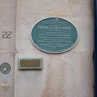
One thing it doesn't mention is that he became the Father of Australian Architecture after being transported for forgery, having gone bankrupt, forged a financial document, been caught, pled guilty, and been sentenced to death, which I think is an interesting detail...
Bower Ashton is an interesting little area just south of the river from me—in fact, the Rownham Ferry used to take people over from Hotwells to Bower Ashton, operating from at least the twelfth century to around the 1930s.
It's a strangely contradictory little area, with a cluster of old and new houses sandwiched in between the busy A-roads and significantly more industrial area of Ashton and the bucolic country estate of Ashton court roughly east to west, and also between Somerset and Bristol, north to south.
I've been around here before, mostly poking around Bower Ashton's arguably most well-known bit, the Arts faculty campus of the University of the West of England, but I'd missed at least Parklands Road and Blackmoors Lane, so I initially planned just to nip across briefly and wander down each in turn. On a whim, though, I texted my friends Sarah and Vik in case they were out and about, and ended up diverting to the Tobacco Factory Sunday market first, to grab a quick flat white with them, extending my journey a fair bit.
To start with, though, I nipped to a much more local destination, to see something that you can't actually see at all, the Gridiron...
(I also used this wander as a test of the cameras in my new phone. I finally upgraded after a few years, and the new one has extra, separate wide and telephoto lenses compared to the paltry single lens on my old phone. Gawd. I remember when speed-dial was the latest innovation in phones...)
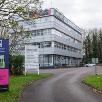
The South West Broadcast Centre for Celador Radio, it says. That certainly explains the big dipole antenna on the roof. I haven't heard of Hits Radio, but I suppose I'm generally more your Radio 4 type.

