Tagged: escarpment
Saint Vincent's Spring
28 Dec 2020
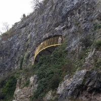
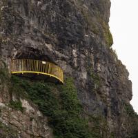
Fractionally outside my one-mile zone, but I got curious about Saint Vincent's spring, whose last remnants you can see in a defunct drinking fountain on the Portway. Along the way I passed Gyston's cave, sometimes called St Vincent's cave, in the sheer wall of the gorge. It's now accessible by a tunnel from the observatory—I tried it about twenty years ago, I think, and still recall the vertiginous moment of looking down from the protruding balcony and realising that you could see straight through the grille floor to the drop below—but from what I can work out the tunnel is relatively recent. Before the tunnel was dug it was accessible only by access across the cliff face, which must have been even more terrifying.
This cave was first mentioned as being a chapel in the year AD 305 and excavations, in which Romano-British pottery has been found, have revealed that it has been both a holy place and a place of refuge at various times in its history.
A few different sources say that the cave became a hermitage and chapel to St Vincent following Bristol's early trading in Iberian wines; St Vincent of Saragossa is Lisbon's patron saint, and a lot of nearby things bear the name.
I'm not sure where the crossover of Vincent and Ghyston happens, though. On the giants Goram and Vincent (or Ghyston), Wikipedia says:
The name Vincent for one of the giants rests on the fact that at Clifton, at the narrowest point of the Avon Gorge, there was formerly an ancient hermitage and chapel dedicated to St Vincent, at or near the present cave in the cliff-face which bears his name. Another (apparently modern) version of the story calls the Clifton giant Ghyston, which is in fact the name, of obscure origin, for the whole of the cliff-face of the Avon Gorge at least as early as the mid-fifteenth century, in the detailed description of the Bristol area by William Worcestre. The place-name was personified to produce the giant's name. Vincent's Cave is called Ghyston cave or The Giant’s Hole in an article in the July 1837 issue of Felix Farley’s Bristol Journal.
In my research on the original Hot Well House, I've seen quite a few contemporary paintings which state their viewpoint as "from St. Vincent's Rock", so in the 16th century it seems the cliff-face name was typically St Vincent Rock rather than Ghyston's Rock, perhaps.
I am, as you can tell, no historian!
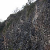
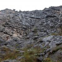
On the way, I also wandered around the base of the popular climbing area, which I think is the site of the old Black Rock quarry.
These are all in the rock-climibing area in the old quarry below Peregrine Watch Point. I saw no peregrines.
The more I research it, the more I find that Hotwells had far better transport links back in Victorian and Edwardian times than it has today. Along with buses that went to more useful places than the City Centre, there were trams, the funicular up to Clifton, the landing stage for paddle steamer services and two railway stations all within easy walking distance of me.
Today I took a day off work as preparation for doing the bookkeeping for my tax return1, and took a wander along to the site of what would have been my nearest station, Hotwells (or Clifton, as it started out in life), nestled in the shadow of the suspension bridge, the Bristol terminus of the Bristol Port Railway and Pier.
From there I wandered down the Portway, following the original line, until I got to the area around Sneyd Park Junction, where the tunnel from the slightly later Clifton Extension Railway joined up with this originally-isolated BPR line. Then I headed up to Clifton through the "goat gully" at Walcombe Slade, seeing the few above-ground bits of evidence of the tunnel (which is still in regular use) along the way.
It was a lovely day, and a good walk, and it was interesting to daydream of the times when I could have walked a few minutes from my flat down to Dowry Parade, caught a short tram ride to Hotwells Stations, and then headed from there to Avonmouth, perhaps even to board a transatlantic passenger service. The completion of the Clifton Extension Railway that linked the Avonmouth station with Temple Meads made relatively direct transatlantic travel from London via Bristol possible, with passengers travelling up from Paddington to Temple Meads, on to Avonmouth on the Clifton Extension Railway and Port Railway and Pier line, then perhaps catching a Cambpell's paddle steamer—which sometimes acted as tenders for large steamers—to a larger ship that was headed out for Canada, say.
1 I've learned that the best approach is to take two days off and deliberately do something that's not my bookkeeping on the first day, as otherwise I just inevitably end up procrastinating and feeling guilty on the first day no matter what. I have an odd brain, but at least I'm learning strategies for dealing with its strange ways as I get older...
2 Information mostly gleaned from Colin Maggs' The Bristol Port Railway & Pier and the Clifton Extension Railway, The Oakwood Press, 1975.
From To Keep Open and Unenclosed, the Management of the Durdham Down Since 1861, Bristol Branch of the Historical Association, 2005:
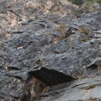
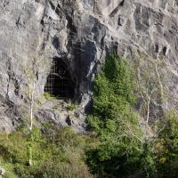
On the Avonmouth side of the Pembroke Road shaft two further shafts were made (one vertical to a ventilation turret in the Gulley and the other horizontal to an opening in the face of the Black Rock Quarry.
So, bearing in mind that this is Black Rock Quarry, I'd say there's a good chance this is the third, and least photogenic, ventilation shaft for the Clifton Extension Railway Tunnel. Later on in this wander we'll see the other two, which are rather prettier.
