Tagged: albermarle-row
Lunchtime Zig Zag Climb
13 Jul 2021
A snappy little trip up the Zig Zag to the shops. It's a steep old route, the Zig Zag, going from just over river level to about the height of the suspension bridge (101 metres) in a compact switchback of a footpath.
I was too busy struggling to breathe to take many snaps of the actual Zig Zag (I've been trying to make it up all the way without stopping the last few times, but I've not quite managed it yet). I did at least take a few snaps either side on this quick lunchtime jaunt to fetch coffee (Coffee #1) and a sarnie (Parsons) from Clifton Village...
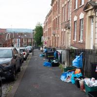
Apparently one of the reasons that collections are being missed (this lot's been on Albermarle Row for nearly a fortnight) is a shortage of drivers. There's a general HGV driver shortage at the moment, as well as a backlog of testing for new drivers.
One Albermarle Row, Granby Green and... People
12 Mar 2021
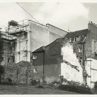
I was browsing some historical photos the other day, and came across "Rear of Unspecified House" in the Bristol Archives' John Trelawny Ross collection, and immediately recognised it as being the back of 1 Albermarle Row, just around the corner from me. I've not had much time to research the history of this odd little addition to Albermarle Row, or what happened to 1-4 Cumberland Place, number 4 of which used to be attached to the side of 1 Albermarle Row, but it was interesting to look at old maps for a few minutes and work out what used to be where.
That all connects with the little local bit of land at Granby Green, too, as it used to be numbers 1-3 Cumberland Place. There was something of a planning battle over Granby Green, and I've included an old edition of Hotwells & Cliftonwood News that I found online, a copy of which would have been popped through my letterbox at the time.
I was also inspired by some old pictures of Hotwell Road to try to put a few more people in my pictures, though I set my pre-focus a couple of extra metres out from normal to make sure I didn't get too close to anyone!
"Rear of unspecified house, Jun 1979"
As soon as I saw this photo, I thought, "That's not unspecified! That's 1 Albermarle Row!" I mean, it still looks like that today, and it's quite distinctive.
From the Bristol Archives, filed under "Bristol City Council: Urban Design and Conservation: Photographs by John Trelawny-Ross/ Photographs taken by John Trelawny Ross during the course of his work as conservation officer for Bristol City Council, within the Urban Design and Planning Department/Dowry Parade, Albermarle Row and St Vincents Parade"
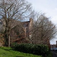
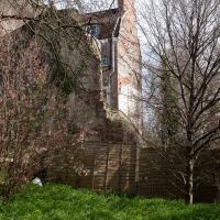
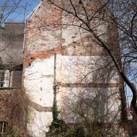
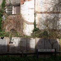
...or rather, the remaining imprint of 4 Cumberland Place on the side wall of 1 Albermarle Row. I don't know why the houses of Cumberland place on the right at the top of the hill disappeared. It seems to have been a gradual process; 1-4 are there on a 1946 aerial photo, then on the 1947-1965 OS maps number 1 has disappeared, and then in the jump to the modern day the whole lot's gone.
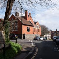
It's the school in the back of the council photo that relly confirms that the picture is of Albermarle Row.
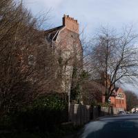
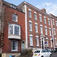
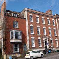
One Albermarle Row. The entire terrace is Grade II* listed apart from number 1, which is clearly a later addition, and merely Grade II listed. It might have looked less of the odd one out when it was hugged by 4 Cumberland Place on the end, but it seems strange to have chosen such a different architectural style, and that big bay window in the middle is odd.
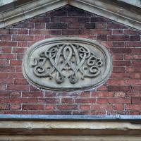
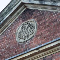
2-9 Albermarle Row were built in 1763 (there's a big plaque in the pediment of number 5 that bears the date, which I've already snapped). The listing for Number 1 says:
Attached house. 1812 on deeds. Brick with limestone dressings, party wall stack and pantile mansard roof. Originally single-depth plan, since extended behind. Late Georgian style.
I think the thing I'm most curious about—and which will presumably remain a mystery—is the renumbering that must have happened. Was Albermarle Row numbered 1-8 from 1763, and then when this parvenu pitched up in 1812, everyone moved their door numbers down one to make room? I'd've expected this to have been dubbed 1B, or something like that...
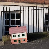
Tiny Houses, Crocodiles and Views
05 Jan 2021
I didn't really intend to record my walk today, but once I was out and about I couldn't really resist taking some pictures. The sun was lovely, but it was cold...
I went to have a peep at the giant sinkhole that's opened up in Canynge Square—ironically, having recently discovered the gardens were public I'd had the (triangular!) square on my list to re-visit for a few days, but now there's no entrance to the gardens due to the danger. The area was well fenced-off for safety, but I tried to get a couple of photos from behind the barriers.
I also explored the area around Camp Road, an real melange of architectures, one of the most mixed-up areas I've seen in Clifton, in fact, and confirmed my friend Claire's suspicion that an earlier snap of a sign from Manilla Road was in fact for a fire hydrant. Nice.
Historically, Albermarle Row was spelled "Albemarle", after George Monck, 1st Duke of Albemarle who was arrested and imprisoned in Bristol in 1642 when he refused to swear an oath supporting the Royalists during the Civil War. Most (but not all) of its street signs are now spelled "Albermarle", apparently after a mistake was perpetuated by a typo in a Council database a while back, and the spelling has spread to Google Maps and the Royal Mail database.
Other incorrect information on the internet about Albe(r)marle Row includes Historic England's listing, which says that this tympanum has "Webb's monogram with 1762."
