Tagged: bicycle-tire
Since setting up a search for Hotwells on eBay I've mostly managed to restrain myself from buying much (or in one case, was outbid, luckily for my finances.) However, I couldn't resist a 1902 flyer for a singalong at the Terrett Memorial Hall, which would have stood five minutes' walk from my flat, overlooking Howard's Lock.
I've found out a fair bit about this non-denominational seaman's mission, including tracking down both a Loxton drawing and an aerial photo of it. The main thing that's eluded me, ironically enough, is finding out who Terrett was, so as a Memorial Hall it didn't do a very good job 😀.
EDIT: Ah! Did a little more digging and found that the Bristol Archives has a Bristol Dock Company document on file called "William Terrett, Esq.; corresp. etc. re proposed erection of a Mission Hall at Cumberland Basin, 1892", so that might be worth a look once the Archives are properly open again. Given that:
Sarah Terrett died suddenly on 25 November 1889, aged 53, after speaking at a meeting of the White Ribbon Army, the temperance organization she had founded in 1878. Following her death many people sent letters of sympathy to her bereaved husband, William. One of these, from the Rev. W. F. James, a minister of the Bible Christians, makes for especially interesting reading. The Bible Christian denomination, to which Sarah and William belonged, was one of the smaller Methodist connexions, and had its heartland in rural Devon, the area where she had grown up. James recalled the hospitality he enjoyed when visiting the Terretts’ home, Church House, in Bedminster, south Bristol...
...I wonder if William Terrett built the hall in memory of his late wife. They were clearly just the kind of temperance movement people who would've founded a seaman's mission to get people together to have a nice non-alcoholic singsong rather than a night out on the tiles.
Anyway. This walk to grab a coffee from Hopper Coffee in Greville Smyth Park was mostly an excuse to post the leaflet, a few other things I found related to it, and some pictures of how the site looks now. I would suggest that the present day is not an improvement.
One Albermarle Row, Granby Green and... People
12 Mar 2021
I was browsing some historical photos the other day, and came across "Rear of Unspecified House" in the Bristol Archives' John Trelawny Ross collection, and immediately recognised it as being the back of 1 Albermarle Row, just around the corner from me. I've not had much time to research the history of this odd little addition to Albermarle Row, or what happened to 1-4 Cumberland Place, number 4 of which used to be attached to the side of 1 Albermarle Row, but it was interesting to look at old maps for a few minutes and work out what used to be where.
That all connects with the little local bit of land at Granby Green, too, as it used to be numbers 1-3 Cumberland Place. There was something of a planning battle over Granby Green, and I've included an old edition of Hotwells & Cliftonwood News that I found online, a copy of which would have been popped through my letterbox at the time.
I was also inspired by some old pictures of Hotwell Road to try to put a few more people in my pictures, though I set my pre-focus a couple of extra metres out from normal to make sure I didn't get too close to anyone!
Harbourside Milestone
17 Mar 2021
The other day I realised (hello, Maggie!) that my next walk would be my hundredth, and that I'd done 393.4km so far. I figured it would be nice to get to 100 walks and 400km on the same walk, so I went for a nice long harbourside wander after work, rather than dashing out at lunchtime. As it turned out, we're just coming up to the time of year where I can leave the house at 5:30 in the evening and there's still just enough light to take photos by the time I've made it around the harbourside. Though only just, and mostly because I've got a full-frame camera that's not bad in low light...
Still, the evening light made a lovely change, and some of the photos turned out to be pretty good photos per se, rather than just record shots of my walk. I'm looking forward to more evening walks like this as summer approaches.
On the way around this evening I wandered through one of the oldest bits of the city to extend my walk and snapped some interesting bits of architecture, including an NCP car park(!) and a nighttime shot of one of my favourite subjects, the clock tower at the Albion dockyard.
I wasn't going to take a very long walk on this nice spring evening; it just happened. I was going to knock off a path or two on Brandon Hill, home over centuries to hermits and windmills, cannons and Chartists, and then just wander home, stopping only to fill up my milk bottle at the vending machine in the Pump House car park.
However, when I heard a distant gas burner I stayed on the hill long enough to see if I could get a decent photo of both the hot air balloon drifting over with Cabot Tower in the same frame (spoiler: I couldn't. And only having the fixed-focal-length Fuji with me didn't help) and then, on the way home, bumped into my "support bubble", Sarah and Vik, and extended my walk even further do creep carefully down the slipway next to the old paddle steamer landing stage and get some photos from its furthest extreme during a very low tide...
I got interested in Bristol's medieval water supplies after poking around near Jacobs Wells Road and Brandon Hill. It was during that research I found out about a pipe that's still there today, and, as far as I know, still actually functioning, that was originally commissioned by Carmelite monks in the 13th century. They wanted a supply of spring water from Brandon Hill to their priory on the site of what's now the Bristol Beacon—Colston Hall, as-was. It was created around 1267, and later, in 1376, extended generously with an extra "feather" pipe to St John's On The Wall, giving the pipework its modern name of "St John's Conduit".
St John's on the Wall is still there, guarding the remaining city gate at the end of Broad Street, and the outlet tap area was recently refurbished. It doesn't run continuously now, like it did when I first moved to Bristol and worked at the end of Broad Street, in the Everard Building, but I believe the pipe still functions. One day I'd like to see that tap running...
There are a few links on the web about the pipe, but by far the best thing to do is to watch this short and fascinating 1970s TV documentary called The Hidden Source, which has some footage of the actual pipe and also lots of fantastic general footage of Bristol in the seventies.
On my walk today I was actually just going to the building society in town, but I decided to trace some of the route of the Carmelite pipe, including visiting streets it runs under, like Park Street, Christmas Street, and, of course, Pipe Lane. I also went a bit out of my way to check out St James' Priory, the oldest building in Bristol, seeing as it was just around the corner from the building society.
There are far too many pictures from this walk, and my feet are now quite sore, because it was a long one. But I enjoyed it.
Swinging By Sydney Row
01 Apr 2021
Another workday, another quick coffee excursion. This time I decided to swing past Sydney Row on the way back from the marina car park where Imagine That have their horsebox. I didn't know until recently that the terrace was built for workers at the adjacent dockyard.
I've also gradually come to the conclusion that I don't really think very two-dimensionally when it comes to finding my way around or associating one place with another. I only realised in the last few days that the odd industrial building that takes up the other half of Syndey Row, the one that's always covered with graffiti, is the back of the dockyard works. In my defence, as it's tucked away in a corner of the little industrial estate that I've never ventured into (I rarely find I have a need for the products of safety valve manufacturers), I don't think I've ever seen the front of the building...
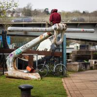
Somebody told me that the four anchors at the corners of Cumberland Basin point to points of the compass. I'm not sure there's that much consistency. The other seem to point NW, NE, and SE; this one seems to be about ten degrees off due east. Maybe I should go down with my compass and check :D
Man on a Mission
17 Apr 2021
I went rather outside my area today, as I went to pick something up from the Warhammer shop on Wine Street (Games Workshop as-was, and before that I think perhaps a rare retail outlet for Her Majesty's Stationery Office? I may be mis-remembering...) Anyway, a friend of mine wanted something picking up and posting to him, so I figured I'd knock some streets off my list along the way.
I first headed for the St George's Road area, walking down the narrow Brandon Steps and finding some strange wall art on Brandon Steep, then headed to the Old City via Zed Alley. The Warhammer shop visit was friendly and efficient, and, mission accomplished, I treated myself to a sausage roll and a flat white from Spicer + Cole, to take away and eat in Queen Square with its current decoration of hearts. I finished off with a detour up Park Street, looking out for St John's Conduit markers, before finally crossing Brandon Hill on the way home.
Quite a long wander, all told, and I'm a bit knackered today...
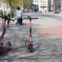
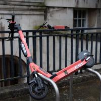
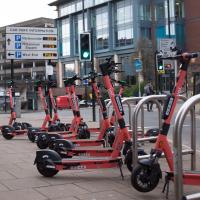
On the whole, I do like the Voi scooters, but they're aways going to suffer from the problem of people parking them in the middle of the pavement.
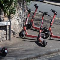
And again, the down side. It's fine for me to wander out into the road to avoid them, but I'd be more annoyed if I were pushing a pram or in a wheelchair.
Howard's Lock
27 Apr 2021
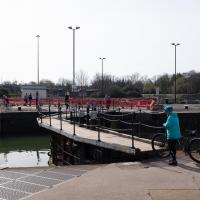
Bits of Entrance Lock have been coned off for ages, mostly the area with the lockkeepers' house on it. My friends Sarah and Vik mentioned at the weekend that it had recently been un-coned, so I wandered that way to cross the outermost lockgates for the first time this year. I don't know whether it's just my mood today or the weather, but it seemed a day for pushing a couple of photos in a more experimental direction in the post-processing...
Shops, Hedgehogs and Cows
06 Jul 2021
I really only took the GPS and camera on a "just in case" basis, as I knew I was only going for a coffee in Greville Smyth Park along a well-trodden path this lunchtime. Still, I saw a few new things along the way, so I figured it was worth uploading the handful of photos I took...
This shop's on the Hotwell Road (no. 257) has been closed for so long I've completely forgotten what it used to be. Hopefully someone's being brave enough to open something new...
Museum of the Moon, and a Bit of Redland
21 Aug 2021
Lisa and I mostly went out to have a look at Luke Jerram's Museum of the Moon as its tour hit Bristol Cathedral—I missed it when it was previously in town, at Wills Hall, I think—but we also took a trek up to Redland. Lisa's kind enough to indulge my strange current fascination with the Edwardian eccentrics that made up the Stella Matutina, so we swung by a couple of places with a vague connection to the Bristol branch of the organisation. Well, it was good walking, anyway...
As a stunning bonus, one of the picture's descriptions has more information than you'd probably want on the Bristol Port Railway and Pier's Clifton Extension Railway line, but I did happen to coincidentally write up this wander after reading about the extension line during my lunch hour at work today. It's a thrilling life, I tell you...