Tagged: condominium
To Bedminster
19 Dec 2020
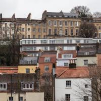
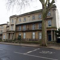
Despite a mild headache, I enjoyed this wander over to Bedminster. The light was lovely, especially toward the end. I always enjoy the view down the streets south of North Street at this time of day/year, with the distant hills backdropping the Victorian terraces.
Sunday Bedmo
20 Dec 2020
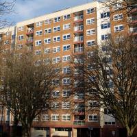
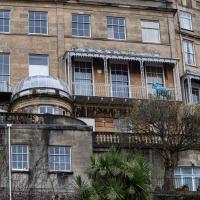
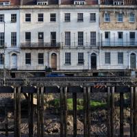
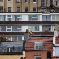
A long meander around bits of Bedminster, from the river to the north to Winterstoke Road to the south, taking a few roads I've seen before, and a few I haven't. The Christmas decorations were an extra bonus.
If you look closely, you can see the single strand of tinsel around a balcony railing that appears to be the sole concession to Christmas cheer in this block.
Solstice Rain
21 Dec 2020
Despite the weather, Sarah and Vik and I wandered around Ashton Court a bit as the sun rose. Not that you could really tell. Sadly, the bit we wanted to watch the sunrise from was closed, because people hadn't been treating the deer with appropriate respect. Ah well, at least it was some exercise.
On Christmas Day in the Morning
25 Dec 2020
A Christmas Day walk with my friends Sarah and Vik, taking in the shipwrecked Shadow and a hilly chunk of Leigh Woods.
I went to have a peep at the giant sinkhole that's opened up in Canynge Square—ironically, having recently discovered the gardens were public I'd had the (triangular!) square on my list to re-visit for a few days, but now there's no entrance to the gardens due to the danger. The area was well fenced-off for safety, but I tried to get a couple of photos from behind the barriers.
I also explored the area around Camp Road, an real melange of architectures, one of the most mixed-up areas I've seen in Clifton, in fact, and confirmed my friend Claire's suspicion that an earlier snap of a sign from Manilla Road was in fact for a fire hydrant. Nice.
Saint Vincent's Spring
28 Dec 2020
Fractionally outside my one-mile zone, but I got curious about Saint Vincent's spring, whose last remnants you can see in a defunct drinking fountain on the Portway. Along the way I passed Gyston's cave, sometimes called St Vincent's cave, in the sheer wall of the gorge. It's now accessible by a tunnel from the observatory—I tried it about twenty years ago, I think, and still recall the vertiginous moment of looking down from the protruding balcony and realising that you could see straight through the grille floor to the drop below—but from what I can work out the tunnel is relatively recent. Before the tunnel was dug it was accessible only by access across the cliff face, which must have been even more terrifying.
This cave was first mentioned as being a chapel in the year AD 305 and excavations, in which Romano-British pottery has been found, have revealed that it has been both a holy place and a place of refuge at various times in its history.
A few different sources say that the cave became a hermitage and chapel to St Vincent following Bristol's early trading in Iberian wines; St Vincent of Saragossa is Lisbon's patron saint, and a lot of nearby things bear the name.
I'm not sure where the crossover of Vincent and Ghyston happens, though. On the giants Goram and Vincent (or Ghyston), Wikipedia says:
The name Vincent for one of the giants rests on the fact that at Clifton, at the narrowest point of the Avon Gorge, there was formerly an ancient hermitage and chapel dedicated to St Vincent, at or near the present cave in the cliff-face which bears his name. Another (apparently modern) version of the story calls the Clifton giant Ghyston, which is in fact the name, of obscure origin, for the whole of the cliff-face of the Avon Gorge at least as early as the mid-fifteenth century, in the detailed description of the Bristol area by William Worcestre. The place-name was personified to produce the giant's name. Vincent's Cave is called Ghyston cave or The Giant’s Hole in an article in the July 1837 issue of Felix Farley’s Bristol Journal.
In my research on the original Hot Well House, I've seen quite a few contemporary paintings which state their viewpoint as "from St. Vincent's Rock", so in the 16th century it seems the cliff-face name was typically St Vincent Rock rather than Ghyston's Rock, perhaps.
I am, as you can tell, no historian!
On the way, I also wandered around the base of the popular climbing area, which I think is the site of the old Black Rock quarry.
Tiny Houses, Crocodiles and Views
05 Jan 2021
I didn't really intend to record my walk today, but once I was out and about I couldn't really resist taking some pictures. The sun was lovely, but it was cold...
Mirror Maze
10 Jan 2021
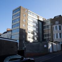
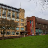
Went for a wander with my friend Lisa—the current lockdown rules seem to be that one local walk for exercise per day with a maximum of one person not in one's "bubble" is fine—up to the University of Bristol area right at the edge of my one-mile perimeter to see the Jeppe Hein Mirror Maze, among other things. On the way we mused about Merchant Venturers, the slave and tobacco trades, and dating in the time of Covid.
I once did a segment on how to photograph lightning from an editing suite at the BBC, which I think was somewhere up there. It was for a programme called Wild Weather of the West, I think, presented by BBC weatherman Ian Fergusson.
I'm not entirely sure where I was as the BBC complex behind this fairly normal-looking buiilding is actually a very large facility that takes up most of the block behind this road, and has a canteen building, the Points West studio and all sorts. I've been in there a few times, for various reasons, including, improbably, having a Greek lesson with Chris Searle, who himself presented the BBC's Greek Language and People decades before...
If it's trying to blend in with the neighbourhood, what on earth are the green windowframes about?
According to the architect's website:
Sheppard Robson’s competition-winning design responds to the University’s vision of creating a world-class research and teaching facility which will attract international students and academics. The architectural ambition of the project was to create a building that respects the neighbouring listed buildings and surrounding conservation area whilst also adding a confident piece of contemporary design to Bristol.
Northern Clifton
16 Jan 2021
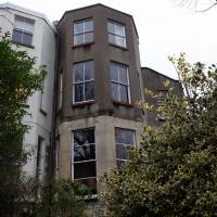
A raggedy wander with my friend Lisa, picking up a few stray streets and venturing only briefly onto Whiteladies Road, where it was too damn busy, given the current pandemic. We retreated fairly quickly. Found a couple of interesting back alleys, and got a very pointed "can I help you?" from a man who was working in his garage in one of the rather run-down garage areas behind some posh houses, and clearly didn't want us just wandering around there.
Snowy Leigh Wander
24 Jan 2021
I started this wander with my "support bubble" Sarah and Vik, after Sarah texted me to say "SNOW!" We parted ways on the towpath and I headed up into the bit of Leigh Woods that's not actually the woods—the village-like part in between Leigh Woods and Ashton Court, where I'd noticed on a map a church I'd not seen before. I found St Mary the Virgin and quite a few other things I'd never experienced, despite having walked nearby them many, many times over many years, including a castellated Victorian water tower that's been turned into a house...
I was thinking about this site the other day, when other photos I'd taken prompted a memory of there being a run-down petrol station on this site relatively recently. I can't find a single photo of that on the web, nor am I entirely convinced I'm remembering correctly.