Tagged: automotive-design
A Random New Year's Day Wander
01 Jan 2022
I picked a fairly arbitrary reason for a wander today. Really, I just wanted to do a New Year's Day wander just to get out of the house and to set a precedent for the year to come.
My ostensible reason was to investigate what looked like a road on my map that quartered the lawn in front of the Ashton Court mansion. As it turned out, this is just a muddy footpath/desire line similar to a half-dozen other tracks nearby, and must be some kind of bug or misclassification with the mapping system I'm using, but that's not important. What's important is that I went for a little walk on the first day of the year. As a bonus, I did happen to wander down a couple of sections of new footpath, so technically I broke some new ground too, which is nice.
Lunchtime Cliftonwood Wander
18 Jan 2022
Another workday, another quick lunchtime trip to get me out of the house. This time my flimsy pretext is a tiny bit of Clifton Vale Close that I'd apparently not walked, and the fact that although I'd walked down Church Lane at least once before I still hadn't taken a single photo of it. Really I just fancied a mosey through Cliftonwood in the sunshine, with the promise of a coffee from Clifton Village at the top of the hill.
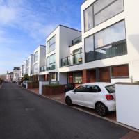
I really do like these little houses. Hate to think how much you'd have to pay for them, though.
Ouch. Just looked it up. Apparently the average property sale price over the last year was £750,000. I suppose the Tesla parked to the left there should have given away the income level; the Model S sells for about £75,000 in the UK.
Bedminster Trip for New Walking Shoes
26 Feb 2022
I needed to buy new walking shoes—my old ones were squeaking and it was driving me up the wall—so I ordered some for collection from Taunton Leisure on East Street in Bedminster, and decided to make picking them up an official wander.
I didn't cover any new ground within my mile, but I did take advantage of the trip to take in a few interesting things just outside my normal radius, mostly New Gaol-related. Along the way there are a couple of sanitation-related diversions, including a visit to a rare manhole cover. You can hardly wait, I can tell!
The Bedminster branch of Asda—pronounced as "Asdawl" by proper Bristolians including my friend Cindy—is enormous and pretty much always busy. It used to be my local supermarket when I lived at Baltic Wharf; I now have a couple of smaller "metro"-style supermarkets I tend to visit now I live in Hotwells. I think the last time I came here I was after something from the pharmacy that my local place didn't have.
Leigh Woods Purple Path
12 Mar 2022
There's a few tracks in Leigh Woods that lie within my mile and show up on my map but that I've not walked yet, so I decided to take one of my traditional big long walks through the woods on this nice crisp sunny morning.
For years—decades, even—I've been doing a similar route from my place, along the towpath to the far woods entrance, up the hill for a varied walk on one of the marked tracks and then across the Suspension Bridge to Clifton Village for a coffee-based reward. It's my default "long walk", really, and I almost always enjoy it. Today, at last, spring actually seemed to be springing, which made for some extra positivity...
My food varies a bit on these forest walks, but I'm quite set in my ways on the drink: lapsang souchong, brewed straight in the Thermos flask at home, with two ice cubes dropped into it before I seal it up. This ensures that the tea is at a perfectly drinkable temperature at this point on the walk. Some rituals are worth experimenting with and perfecting.
I noticed I had a few things on my "potential wanders" list that could all be done relatively close to home, and in a fairly straight line, so I set off at lunchtime to recreate a photo of a now-defunct pub, wander behind a Spar (which turned out to be more interesting than I'd expected, but I admit it's a low bar) and spend some time browsing in Dreadnought Books before coming home via a coffee from Spoke & Stringer, a little diversion up Gasworks Lane and a tiny bit of the Rownham Mead estate I'd somehow previously skipped.
Here's the Spring Garden(s)/Durty Nelly's/La Demi Lune as it looks today. Rather dull modern accommodation, sadly. I understand they may have extended the building back into the garden to make it roomy enough to be flats.
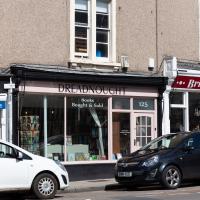
On St George's Road. This is where I ended up spending most of my stopping time on the walk. I managed to resist most temptations and came away having only spent £2 on a paperback of The Mill on the Floss. I read Silas Marner a while back and really liked it, so I've been wanting to try some more Eliot.
I shall add it to my tsundoku collection.
Easter Monday Gardens and Flowers
18 Apr 2022
I didn't really set out with a theme of flowers and gardens in mind for this walk. I just fancied heading up to Clifton Village to get lunch. As it turned out, though, Spring was springing, so a minor theme emerged as I started off with the graveyard flowers of Hope Chapel and wandered up to see the beginnings of the new wildflower garden at Clifton Hill Meadow.
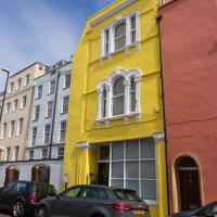
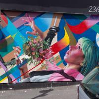
I reckon this has recently been repainted. It definitely caught my eye in the spring sunshine.
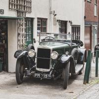
Made by the Sunbeam Motor Car Company, this was first registered in 1925, according to the DVLA's online enquiry system. Looking pretty good for its age. The mechanic working on it looked to be of similar vintage.
I've been pretty awful at reading so far this year, apparently averaging about one book per month. That's a far cry from 2019, say, where I got through 41 books in the year. Today's wander was prompted by my rubbish reading, as I needed to go hand back some books to the library, because I'd managed to renew them so many times that I hit the limit on renewals. Oops. Several of them were still unread.
So, off to the Central Library for me, tail between my legs. On the way there I did my best to recreate a historical photo of Dowry Square; while I was in the area I walked under the adjacent Norman arch and poked around behind the Cathedral, and I also had a little diversion to the city centre and came back along the south side of the river, hitting some trouble with the lock gates as I finally crossed the harbour back towards home.