Tagged: cityscape
A Cliftonwood Revisit with Lisa
10 Jul 2021
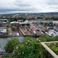
Lisa had a couple of hours to spare before going up in a hot air balloon (exciting!) so we went for a quick local walk, revisiting a bit of Cliftonwood we've seen before, exploring the secret garden I'd visited before that I thought she'd enjoy (I didn't take any new photos there) and then pushing on to another garden, Cherry Garden. Last time we passed this way, I'd noticed the gate, but we hadn't gone in as I'd assumed it was private. I'd since found it on CHIS's list of communal gardens in Clifton, so I wanted to have a look inside this time, and try to figure out whether it was private-communal or public, and possibly Council-owned, like several of the other gardens in Clifton.
I recently indulged myself by buying a little piece of history. I've mentioned Samuel Loxton and featured and linked to his drawings before, often in the eminently browsable Loxton Collection albums that Bristol Libraries has on Flickr. So when I saw a Loxton drawing of Hotwells pop up on eBay, I decided to get myself a little treat.
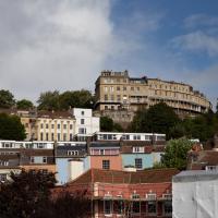
I don't think there's any Loxton drawing that features the road I actually live in—it's not very visible from anywhere else, not being one of these Clifton terraces that's perched at the top of a hill, or anything like that, and it's invisible in most views of the area. However, this Loxton drawing, Hotwells, Looking across the river from near the Clifton Bridge station, is probably the closest near-miss I've seen.
I decided to wander out one morning and see if I could reproduce the picture, and also take a photo or two of what's now become of the Clifton Bridge Station, which is still just about discernible in places.
(Then on an even stranger whim I decided to check out a possible little cut-through from Cumberland Road to the harbourside I'd been eyeing up on my commute to work, so walked to Wapping Wharf for a croissant via this potential new route, but that bit's not quite as interesting...)
I'd broadly planned to figure out the vantage point Loxton had used for his drawing by lining up Windsor Terrace with The Paragon, so I started taking bearings fairly early.
Near and Far
05 Jan 2022
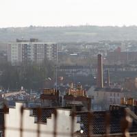
I took advantage of a rare recent day where it wasn't tipping down with rain to get away from my desk on a lunchtime workday and head up to Clifton Village. I'd hoped to snap a reproduction of historical photo which I'd worked out had been taken from the Suspension Bridge, but the gods were not smiling on me. Still, taking only a nice long lens with me worked out very well as the lovely haze of the day made more distant views quite dramatic...
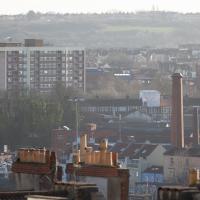
The Nova Scotia pub bottom right, then behind it the chimney of the previously coal-fired pump house at Underfall Yard. In the background behind that and to the right is the Tobacco Factory, with what looks like a little red shed on its roof that I presume is actually a stairwell exit to the roof. On the left-hand side at about the same distance away is the large council block of Little Cross House. It always seems quite calm and tidy when I pass it, which is very regularly, but the Bristol Post painted a different picture in 2019 in their story headlined "Residents of 'forgotten' tower block demand council action over 'nightmare' living conditions":
People living in Little Cross House, a 13-storey council tower block in Southville, said their lives are plagued by poor living conditions, damp and mould, and neighbours from hell, drug dealers, discarded needles, vandalism and anti-social behaviour.
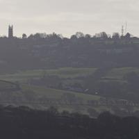
In the far distance, across the Southville rooftops, are the green hills of the Knowle West Health Park, I think.
Lunchtime Reproduction (of an old photo...)
17 Jan 2022
This was basically the quick lunchtime jaunt I tried to do at the beginning of January, only this time I actually managed to get to roughly the viewpoint I'd been hoping for to recreate a historical photo of the Bristol International Exhibition.
I did this walk about a month ago, but I've been a bit poorly and not really up to doing much in my spare time, and it's taken me this long to even face processing even these few photos. Hopefully normal service will be resumed at some point and I can carry on trying to walk any roads and paths that I need to do to make this project feel complete...
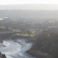
Unlike my last attempt I successfully managed to get somewhere near the vantage point of the historic photo this time...
I should probably have tried to get it at high tide to make it a bit more comparable, but you can't have everything.
You can see the White City Allotments—those glints of light toward the middle are mostly reflections from greenhouses—where the "White City" of the Exhibition used to stand. There's still a glimpse or two of the railway line to Portishead to be seen, too, along with a vestige of the Rownham Ferry slipway.
Mostly though it's the modern things that stand out—the long line of flats along Paxton Drive, the curve of Brunel Way across the river, and the roof of Ashton Gate Stadium...
I mostly went out to hang out with my friends Sarah and Vik in Bedminster, but along the way I thought I'd take a closer look at something a little nearer home: the last crossing point of the Rownham Ferry.
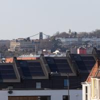
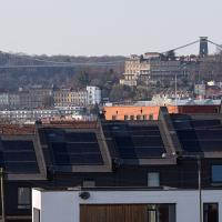
A sign of the times: all the new build homes of Balfour Road have solar panels on top. I bet they're grateful of that, given the current energy price crisis.
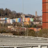
It's interesting to be able to look pretty much a mile back and see the familiar buildings of home. Descending from the top right in the distance we can just see the Observatory on Observatory Hill, then the end of Royal York Crescent, then the Paragon just eclipsing the suspension bridge, then below the bridge on the left there's Windsor Terrace and the more modern Windsor Court flats just visible behind the Bedminster foreground.
Getting back to the Rownham Ferry, the Ashton Avenue Bridge is one of the reasons it was closed. On the excellent Bristol City Docks website you can find a photo called "Rownham Ferry c1906 with Ashton Avenue Bridge nearly built.".
As you'll see in that photo, at low tide the Rownham Ferry was basically just a bridge made out of boats, so it probably still seemed a quick shortcut compared to walking all the way to Ashton Avenue Bridge. I imagine the foot traffic gradually migrated to the new bridge as the ferry was a more daunting prospect at high tide, from what I can gather. Also, the combined road/rail bridge would have allowed people to get the train across the river, rather than stopping at Clifton Bridge Station and using the ferry, I think.