Tagged: daytime
A Coffee and a Curve
27 Mar 2022
I wanted to have a wander along to the Tobacco Factory Market for some shopping, and checking the map for any leftover nearby streets I noticed a tiny curve of road on the way into the modern flats at Paxton Drive that it didn't look like I'd walked down before. I wouldn't take me too far out of my way, so I decided to head there first and then across to North Street to get my groceries and a coffee...
I noticed I had a few things on my "potential wanders" list that could all be done relatively close to home, and in a fairly straight line, so I set off at lunchtime to recreate a photo of a now-defunct pub, wander behind a Spar (which turned out to be more interesting than I'd expected, but I admit it's a low bar) and spend some time browsing in Dreadnought Books before coming home via a coffee from Spoke & Stringer, a little diversion up Gasworks Lane and a tiny bit of the Rownham Mead estate I'd somehow previously skipped.
And we'll end on a high note, as Holy Trinity's belfry was looking particularly eye-catching today. The clock's right, too, which is rare in a public clock these days. The bell is back to ringing during the daytime at the moment. It was turned off temporarily during the pandemic as some locals were complaining of losing sleep to it, as it used to ring all night, but the church did some work after running a small campaign for donations to make the timing mechanism more flexible, and now it rings on the hour during the day but is silent during the small hours, at least. It sometimes reminds me that it's time for me to jump on a Teams call when I'm working from home. I find its regular bonging a reassuring Hotwells presence.
Easter Monday Gardens and Flowers
18 Apr 2022
I didn't really set out with a theme of flowers and gardens in mind for this walk. I just fancied heading up to Clifton Village to get lunch. As it turned out, though, Spring was springing, so a minor theme emerged as I started off with the graveyard flowers of Hope Chapel and wandered up to see the beginnings of the new wildflower garden at Clifton Hill Meadow.

A Swing of the Plimsoll Bridge
24 Apr 2022
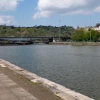
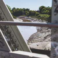
I was originally going to head over to the Ashton area to see if I'd missed any bits around the football stadium—and also to grab some lunch from the Tobacco Factory Market—but in the end I got a little distracted by having accidentally chosen exactly the right time to see the Plimsoll Bridge swing on one of the first busy days of Spring, where a lot of pleasure trips tend to head out down the Avon (and possibly the New Cut) from Hotwells.
In the end I mostly snapped that, and just a couple of photos from the Ashton area where I grabbed some lunch but didn't do any new exploring.
A Quick Swing Past Ashton Court
05 Jun 2022
Another day not dissimilar to my last wander: I'm feeling a bit tired and rather than just moping around the house I thought I'd find some tiny bit of somewhere that I'd not yet walked and get outdoors. This time I headed for the Tobacco Factory Market in Bedminster, as I often do, but went the long way around via Ashton Court Mansion as I knew there were some footpaths and a small section of road I'd not ticked off up there. Finishing all the Ashton Court footpaths will be quite a long job, but you've got to start somewhere...
I did feel rather better by the time I got home, and, pretty much astoundingly given the weather forecast, managed to avoid the rain completely.
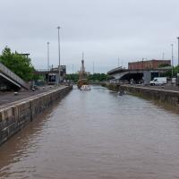
I'd normally walk over those open lock gates she's just sailed through, but it's easy enough to walk down to the gates at the river end.
The technique that Ant Carver used for this piece, called "Love Me/Love Not", is intriguing. I recommend reading the write-up on the always-informative Natural Adventures.
I've been pretty awful at reading so far this year, apparently averaging about one book per month. That's a far cry from 2019, say, where I got through 41 books in the year. Today's wander was prompted by my rubbish reading, as I needed to go hand back some books to the library, because I'd managed to renew them so many times that I hit the limit on renewals. Oops. Several of them were still unread.
So, off to the Central Library for me, tail between my legs. On the way there I did my best to recreate a historical photo of Dowry Square; while I was in the area I walked under the adjacent Norman arch and poked around behind the Cathedral, and I also had a little diversion to the city centre and came back along the south side of the river, hitting some trouble with the lock gates as I finally crossed the harbour back towards home.
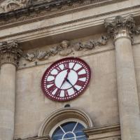
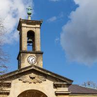
Pause for a moment first to admire the frieze and the acanthus-topped columns, but then check out the clock. It's not far off the right time, which is unusual for a public clock these days. But even a broken clock is right twice a day, right? Not this one—it would still be right four times a day, as it's got an extra minute hand. Before time was standardised across the country, this clock would show both local time and "Railway Time", i.e. Greenwich Mean Time.
It's directly over the entrance to Saint Nicholas Market, formely the Corn Exchange, but sadly they're closed on Sundays, so I couldn't take my usual wander through.
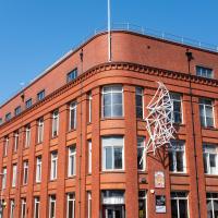
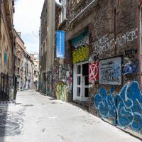
The Mother's Ruin and Seamus O'Donnell's, just to the left here, are both good pubs. Sandwiched in between them at the moment is Shall Not Fade, who sell plants, vinyl records and clothes. The also, apparently, run a record label and a festival. I was tempted by a calathea, but I didn't want to be carrying it around for the next couple of hours. I'll have to come back another day.
I'm in the habit of going over to the Tobacco Factory Market on a Sunday. I think I've walked all the routes around that way, but as a Plimsoll Bridge swing let me cross the road to the far side of Brunel Way on my return journey and I took a couple of photos of the brownfield development at the old Ashton Gate Depot site I thought I'd call it a Wander and pop some photos up.
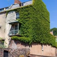
Well, technically that's Freeland Place, I suppose, but I was standing on Granby Hill to take the photo. I wonder how many photos of this fab house with its wrapping of Boston ivy I've taken over the years? I find it hard to resist on a nice clear day, especially if there aren't any cars parked on the hill and the ivy is in full effect.