Tagged: black-and-white
Gothic Revival
08 Dec 2020
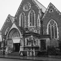
I had a chance to dash down a few new roads during my lunchtime jaunt today. My favourite feature was 7 Wetherell Place, at the corner of Frederick Place, one street behind the University of Bristol Students' Union building. Apparently I'm a sucker for gothic revival, which seems appropriate for this little project, which is reviving my interest in the local area.
The listing starts "1860. By JA Hansom. For himself".
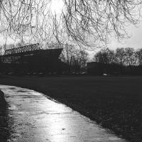
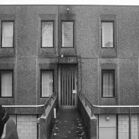
The back of the Union. I've been inside a few times — I had a summer pass to the swimming pool for a while, and I saw Alabama 3 in the Anson Rooms once.
Nowhere New
10 Dec 2020
I didn't have any time to find a new place to go today, so I'm treading old ground here. I did buy a tub of duck food from Amazon last week and today I remembered to take a little bagful of it with me on my trip to Imagine That coffee, and spent a few minutes feeding the marina slipway ducks on the way back. This is a Bristol tradition I've seen other people doing many times, but never tried myself. It was quite genteel until the seagulls cottoned on, then it became something of a brawl.
Quick Hopper Coffee
11 Dec 2020
No new streets today—just out for a quick coffee from Hopper in Greville Smyth. Got caught in a bit of a rainstorm on the way out, but it didn't last long enough to bother me much.
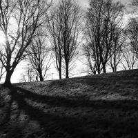
Bedminster, Ashton, Ashton Court sunset walk
12 Dec 2020
A walk with Sarah focusing on Ashton and the surrounds, taken on a day with really nice light around sunset. Just what I needed.
Rainy Clifton
13 Dec 2020
A long walk around Cliftonwood and Clifton with my friend Lisa, taking in some of the 12 Days of Christmas display at Queens Parade, picking up a take-away coffee from Pinkmans of Park Street, and poking our heads up against the glass of SS Peter and Paul Catholic Cathedral.
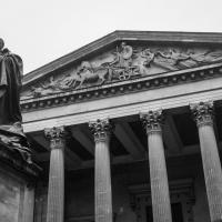
The pediment apparently is "...depicting Wisdom in her chariot ushering in the morning, and followed by the Three Graces" according to the Pevsner guide.
Apparently the tympanum depicts Saint Peter, teaching. You'd have thought they might've gone for Saint Paul...
We presumed this was the presbytery, and having checked the plans, we were right. Entered via a bridge.
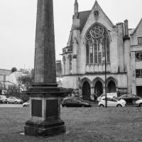
I did make out the names Pitt and Chatham on this obelisk, but a lot of it was in Latin and I coudln't quite work out what it was about. Apparently it was created to honour William Pitt (the Elder), who I didn't know was Earl of Chatham, by Sir William Draper, who was living in nearby Manilla Hall. When Manilla Hall was demolished and replaced by Manilla Road, the obelisk was moved here.
Cliftonwood and Clifton Village Lunchtime Stroll
14 Dec 2020
The lunchtime walk has been feeling a bit of a chore lately, especially as I only have an hour and have to keep a mental watch out for my "bingo" point or risk being late back. Today I went for a deliberately brief local walk and got home in time to have lunch on my sofa rather than while I was back at work.
It's interesting filling in the gaps in my Clifton Village knowledge, especially starting to "see" the bits I can't see, the negative spaces. The size of both Fosseway Court and the Bishop's House gardens (check out the latter on Google Maps for an idea) are both something I've noticed by just getting to know the areas around them. I may also have to walk into the driveway of the very well-hidden Nuffield hospital to get an idea of how big it is.
None of those are anything compared to the trick of hiding the gargantuan public school that is Queen Elizabeth's Hospital so well that I keep on forgetting it's there, until a glimpse of it from somewhere like Lower Clifton Hill reminds me about it, of course...
I think when I first arrived in Hotwells, it was sort-of-officially St Andrew's Churchyard Walk, or Lime Walk (those are pleached lime trees), but Birdcage Walk, which I think was more of a nickname, is what shows up on Google maps now. Given that St Andrews itself was destroyed by the Luftwaffe in 1940, I suppose there's less of a landmark to hang the name on these days.
Edit to add: I eventually discovered that the original Bird Cage Walk was the path across Victoria Square, adjacent, and what it used to look like, which makes the name make a lot more sense. I think it's only reasonable that the name migrated as Lime Walk looked more like a birdcage, and the Victoria Square path less like one.
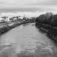
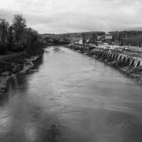
Drained Basin
15 Dec 2020
On the down side, I got to Bedminster and found long enough queues at both Mark's Bread and Hopper Coffee that I gave up on the idea of buying a drink and a pasty (from the former) or a mince pie flapjack (from the latter.) On the up side, I got to take some pictures of Cumberland Basin being drained and sluiced out, part of its regular maintenance cycle.
Gardens and Cottages
17 Dec 2020
I think the cute little Duncan Cottage was my favourite bit of this wander up the hill to get coffee and a pain-au-raisin from Twelve, though I did enjoy gently musing on the public and private gardens of Clifton, inspired by a closer pass than usual to Royal York Crescent's garden.
I managed absent-mindedly to clear my GPS track before saving it, so this hand-created track-log may cause me problems in the future. I suppose we'll see.
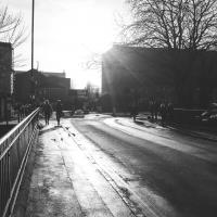
To Bedminster
19 Dec 2020
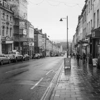
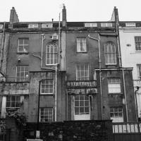
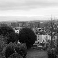
Despite a mild headache, I enjoyed this wander over to Bedminster. The light was lovely, especially toward the end. I always enjoy the view down the streets south of North Street at this time of day/year, with the distant hills backdropping the Victorian terraces.
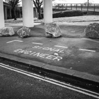
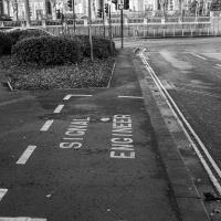
I have to think that if you need a specific parking place marked out for your signal engineer, it might be an indicator that your traffic lights aren't terribly reliable.
Sunday Bedmo
20 Dec 2020
A long meander around bits of Bedminster, from the river to the north to Winterstoke Road to the south, taking a few roads I've seen before, and a few I haven't. The Christmas decorations were an extra bonus.
Something tells me Tom might be doing a timelapse, or similar, and needs to remember exactly where his viewpoint should be. I've thought of doing similar with my shots of the Avon Gorge, but they were only idle thoughts.