Tagged: black-and-white
Quick Clifton Jaunt Finishing with Southville
09 Jan 2022
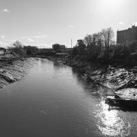
It's been pretty dismal recently, weather-wise, so when Sarah called up to say that she and Vik had just left the swimming pool at the student union building up in Clifton, and would I like to join them for a trip to the Last Bookshop, also known as The £3 Bookshop, for reasons you can probably deduce, I leapt at the chance.
Not many photos on this walk, but I did manage to get down a little road I'd never been to before, basically just the access road to a car park at a block of flats, but it was on the map looking all tempting, so I figured I'd knock it off the list as we were passing.
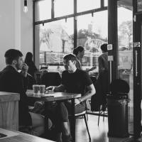
I love Coffee Under Pressure's coffee, so I usually grab something from them when I'm passing. I've got to admit, though, being in a relatively confined space with a bunch of other people is giving me the heebie-jeebies a bit in the time of the Omicron variant. I got a quick take-out, wearing my mask, and ran.
Bedminster Trip for New Walking Shoes
26 Feb 2022
I needed to buy new walking shoes—my old ones were squeaking and it was driving me up the wall—so I ordered some for collection from Taunton Leisure on East Street in Bedminster, and decided to make picking them up an official wander.
I didn't cover any new ground within my mile, but I did take advantage of the trip to take in a few interesting things just outside my normal radius, mostly New Gaol-related. Along the way there are a couple of sanitation-related diversions, including a visit to a rare manhole cover. You can hardly wait, I can tell!
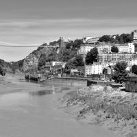
Leigh Woods Purple Path
12 Mar 2022
There's a few tracks in Leigh Woods that lie within my mile and show up on my map but that I've not walked yet, so I decided to take one of my traditional big long walks through the woods on this nice crisp sunny morning.
For years—decades, even—I've been doing a similar route from my place, along the towpath to the far woods entrance, up the hill for a varied walk on one of the marked tracks and then across the Suspension Bridge to Clifton Village for a coffee-based reward. It's my default "long walk", really, and I almost always enjoy it. Today, at last, spring actually seemed to be springing, which made for some extra positivity...
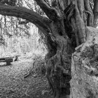
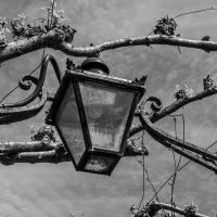
One of my two favourite trees in the woods, the other being the giant redwood in the Leigh Court arboretum area.
Easter Monday Gardens and Flowers
18 Apr 2022
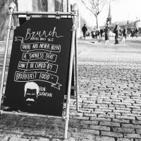
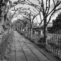
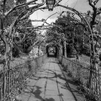
I didn't really set out with a theme of flowers and gardens in mind for this walk. I just fancied heading up to Clifton Village to get lunch. As it turned out, though, Spring was springing, so a minor theme emerged as I started off with the graveyard flowers of Hope Chapel and wandered up to see the beginnings of the new wildflower garden at Clifton Hill Meadow.
Boyce's Avenue, named for Thomas Boyce, according to Veronica Smith's excellent The Street Names of Bristol (I'm borrowing the Clifton Library copy at the mo):
In 1763, Thomas Boyce, a wig-maker, kept lodging houses here for visitors to the Spa. Within ten years he was bankrupt.
I wonder if the building of nearer lodgings down in Hotwells might have been part of the cause? The street I live in was one of those!
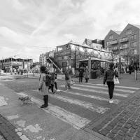
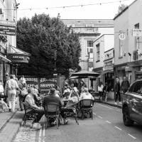
As you can see, it's fair bustling these days, especially on a bank holiday with the cafes doing a good trade. Despite the giant SUV in the picture, which was presumably doing a shop delivery, the street is pedestrianised and mostly car-free these days, at least at certain hours.
This has led to a spreading of pavement cafe culture in Clifton Village, with Princess Victoria Street being the latest (somewhat controversial) experiment.
A Quick Swing Past Ashton Court
05 Jun 2022
Another day not dissimilar to my last wander: I'm feeling a bit tired and rather than just moping around the house I thought I'd find some tiny bit of somewhere that I'd not yet walked and get outdoors. This time I headed for the Tobacco Factory Market in Bedminster, as I often do, but went the long way around via Ashton Court Mansion as I knew there were some footpaths and a small section of road I'd not ticked off up there. Finishing all the Ashton Court footpaths will be quite a long job, but you've got to start somewhere...
I did feel rather better by the time I got home, and, pretty much astoundingly given the weather forecast, managed to avoid the rain completely.
I've been pretty awful at reading so far this year, apparently averaging about one book per month. That's a far cry from 2019, say, where I got through 41 books in the year. Today's wander was prompted by my rubbish reading, as I needed to go hand back some books to the library, because I'd managed to renew them so many times that I hit the limit on renewals. Oops. Several of them were still unread.
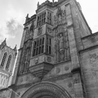
So, off to the Central Library for me, tail between my legs. On the way there I did my best to recreate a historical photo of Dowry Square; while I was in the area I walked under the adjacent Norman arch and poked around behind the Cathedral, and I also had a little diversion to the city centre and came back along the south side of the river, hitting some trouble with the lock gates as I finally crossed the harbour back towards home.
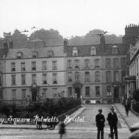
I don't know anything about this photo, really; I saw it pop up on eBay in one of my automated searches for "Hotwells" and this nice, open view of Dowry Square, which is a lot more overgrown these days, made me click that "buy" button. This is a print from a negative in a private collection but more that that I can't really tell you. The "Hepworth" could be Watler Hepworth, as it seems there was a Bristol photographer of that name in about the right period, which I"m guessing to be sometime between the First and Second World Wars. The tram rails and electrical lines are still in place, as you can see.
One nice detail is the Bass signs in the windows of what was clearly still back then the York Hotel on the corner of the square. There's some pictures of what I've been assuming is the main bar entrance that faces onto the main road and remains quite well-preserved in a moment...
And now I've killed some time wandering around town, here we are back at the other side of the Abbot's gate on the way to collect the book I wanted from the library now it's actually past 1pm and the place is open. At least I accidentally found an interesting art exhibition along the way.
I'm in the habit of going over to the Tobacco Factory Market on a Sunday. I think I've walked all the routes around that way, but as a Plimsoll Bridge swing let me cross the road to the far side of Brunel Way on my return journey and I took a couple of photos of the brownfield development at the old Ashton Gate Depot site I thought I'd call it a Wander and pop some photos up.
I've recently been playing the computer game Life Is Strange, and it's inspired me to get a bit more snappy. The heroine is a photography student, and part of the game is to go around snapping artistic pics with her Polaroid camera. I don't have a polaroid, but the game did inspire me to stick the simple 50mm prime lens on the camera and to trust my instincts on things to snap. This was probably the best result of the day.