Tagged: floor
In Between
06 Feb 2021
A lovely walk in the early spring sunshine with my friend Lisa. We headed directly for Jacobs Wells Road, to start off around the scene of one of our earlier walks, but this time took in Jacobs Wells from QEH upward, stopping to snap some photos of a Bear With Me, some interesting areas between Park Street and Brandon Hill including a peculiarly quiet enclave with a ruined old build I'd never found before, then crossed the Centre to grab take-away pies from Pieminister (I had the Heidi Pie) and head back to my place down the harbourside.
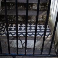
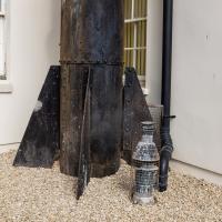
These steps up to a car park look like they're the remnants of an earlier house at the end of this terrace, but that's just a guess. Wouldn't surprise me to find that the terrace lost its end house during the war, though.
(Photographic Lack of) Worcester Terrace
09 Feb 2021
A nice walk, but something of a failure, photographically. I went to knock Worcester Terrace off my list, a not dissimilar terrace to Vyvyan Terrace, but one street further away from me. Like yesterday, it was very chilly but this time I went prepared with an extra layer and a winter coat. I think this may have been my downfall, as it may have been the X100T's control wheel brushing against the coat that put it in aperture priority mode at f/16, which I didn't notice at the time, and made most of my photos a little too blurry to use. Apparently in this mode, the X100 doesn't bump up the ISO if it can tell things might be a little too wobbly. Ah well.
So, a nice enough walk, and technically I did Worcester Terrace, but if you didn't take a photograph, were you really there? I'll have to go back...
Clifton Village, including Oxford Place
15 Feb 2021
I've noticed Oxford Place as a tiny little side/back road I've overlooked on my wanders a few times. Today I decided to pop down and have a look, as well as taking a few general snaps of Princess Victoria Street, which I thought deserved more pictures, as it's basically my closest decent shops, and in the Beforetimes I'd visit the Co-Op up there all the time, as well as the cafes (you'll be missed, Clifton Village branch of Boston Tea Party, recently closed in favour of Eat a Pitta.)
I'm definitely becoming more familiar with the area through the One Mile Matt jaunts and associated reading. Today I didn't just think, "oh, I'll head home down that weird alleyway with the electrical substation in it"—no, I thought, "I'll head home down Hanover Lane", because I actually knew its name. And on the way back from there I nodded sagely to myself as I passed St Vincent's Road, knowing now which St Vincent it's likely to be (St Vincent of Saragossa) and also eyed up the modern flats on Clifton Vale and wondered if they might have been built on the site of the former Vauxhall Pleasure Gardens... I don't know all the answers, but at least I have some idea of the historical questions I'm interested in.
I'm glad my friend Lisa joined me today; she drove in from Shirehampton and told me that the Portway was looking rather lovely, so we set off that way. She's also braver than I am when it comes to doing urbex stuff, so this was just the opportunity to take a peek into the Portnalls Number One Railway Tunnel/Bridge Road Deep Valley Shelter whose entrance I'd found on a previous wander.
It was definitely dark and spooky and impressively big, with a side tunnel that Lisa explored that leads to a little door I don't think I've previously noticed on the side of the Portway. I didn't get many photos—even my astoundingly powerful little torch (£) didn't do much to light things up, and you're not going to get much joy hand-holding a camera in that darkness—but I did shoot a little video, which I might edit and add later.
After plumbing the bowels of the earth, we went up Bridge Valley Path to Clifton, explored some bits around the College and Pembroke Road, then came home via Foliage Cafe for coffee. Nice.
Harbour Circumnavigation
01 Mar 2021
Normally I don't have enough time in my lunch hour to get all the way around the harbourside. This is a shame, as Wapping Wharf is a great place to get coffee and a snack, but it's pretty much diametrically (perimetrically?) opposite me on the harbour. Today I had the day off, so I decided to go and knock off a few streets around Anchor Road that I'd not covered, as well as visiting the site of the Read Dispensary (well, one of them) and dropping into Mokoko for one of their astounding almond croissants. From there I came back along the south side, checking out the views from as much of the Chocolate Path as you can venture down at the moment, and swapping from Cumberland Road to Coronation Road at Vauxhall Bridge.
There's a lot of meh photos on this walk—my chief output from this project could be politely described as "record shots"—but a few turned out well, especially those of Vauxhall Bridge from the Chocolate Path, which reminded me how much of a loss the current closure of the Chocolate Path is to walkers and cyclists in Bristol.
I got interested in Bristol's medieval water supplies after poking around near Jacobs Wells Road and Brandon Hill. It was during that research I found out about a pipe that's still there today, and, as far as I know, still actually functioning, that was originally commissioned by Carmelite monks in the 13th century. They wanted a supply of spring water from Brandon Hill to their priory on the site of what's now the Bristol Beacon—Colston Hall, as-was. It was created around 1267, and later, in 1376, extended generously with an extra "feather" pipe to St John's On The Wall, giving the pipework its modern name of "St John's Conduit".
St John's on the Wall is still there, guarding the remaining city gate at the end of Broad Street, and the outlet tap area was recently refurbished. It doesn't run continuously now, like it did when I first moved to Bristol and worked at the end of Broad Street, in the Everard Building, but I believe the pipe still functions. One day I'd like to see that tap running...
There are a few links on the web about the pipe, but by far the best thing to do is to watch this short and fascinating 1970s TV documentary called The Hidden Source, which has some footage of the actual pipe and also lots of fantastic general footage of Bristol in the seventies.
On my walk today I was actually just going to the building society in town, but I decided to trace some of the route of the Carmelite pipe, including visiting streets it runs under, like Park Street, Christmas Street, and, of course, Pipe Lane. I also went a bit out of my way to check out St James' Priory, the oldest building in Bristol, seeing as it was just around the corner from the building society.
There are far too many pictures from this walk, and my feet are now quite sore, because it was a long one. But I enjoyed it.
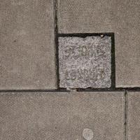
Believe it or not, this little pavement marker says "St John's Conduit" and marks the still-functional Carmelite water pipe that was built in 1267 to bring water from a spring near the top of Park Street to the Priory where Bristol Beacon now stands, with a "feather" branch added later (1376) to bring water to St John's church. Source: Bristol's Fascinating Fountains, Temple Local History Group
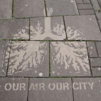
Clever: stencil out the pavement, then pressure-wash it, to make your point by highlighting the discolouration that's partly caused by airborne particulate pollution.
This isn't the Russian Orthodox Church; it's Browns bar and restaurant, over the road. It's quite a posh building, and used to be the city museum and art gallery.
A London Wander in Southville
10 Apr 2021
There's a bit of Southville that I've been meaning to get to for some time, where the streets seem to take some strong inspiration from London. There's a Camden Road that crosses with an Islington Road, and a Dalston Road, even an Edgeware Road. For me these names are more evocative than the rather more exotic names I passed by to get there—Sydney Row or Hanover Place, say, because I've actually been to the places in London. The last time I was in Islington I saw Monkey Swallows the Universe play at The Angel, and I can't think of Camden without remembering a gondola trip with my friend Tara where a cheery youth played Beatles music for us on a saz...
I really liked this little area, with its mostly well-kept pretty houses and hints here and there of the creative side of the residents. It's arty and down-to-earth at the same time, and I wouldn't mind living there, I think.
On the way there I got the chance to walk through Underfall Yard for the first time in a while, and on the way back I had my first take-away hot food for many months, grabbing some crispy fried squid from the excellent Woky Ko at Wapping Wharf.
Desultory Coffee Wander
16 Apr 2021
Another day, another quick dash out for a coffee. I did at least try to take a different route from normal, especially on the way back, where I yet again got a bit lost in the strange paths, flyovers and underpasses that make up the odd maze of pedestrian "infrastructure" among the concrete jungle between the west of Greville Smyth and my neck of the woods in Hotwells. I swear one day I'll take a turn I've not tried before and end up being gored by a Bristolian minotaur.
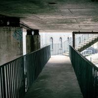
Some of the Cumberland Basin Flyover System's pedestrian pathways really do feel like you're making your way through a post-apocalyptic computer game.
Leftovers with Lisa
01 May 2021
I didn't get to all the little leftover streets around the northeastern part of my area in today's wander, but I definitely knocked a few off the list, plus Lisa and I enjoyed the walk, and didn't get rained on too badly. We spotted the hotting-up of Wisteria season, checked out Birdcage Walk (both old and new), ventured onto the wrong side of the tracks1 and generally enjoyed the architecture.
1 Well, technically we probably shouldn't have been on the grounds of those retirement flats, but nobody started chasing us around the garden with a Zimmer frame
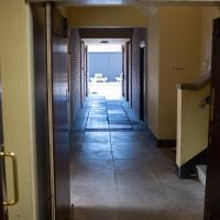
This basement club will be more student flats soon, by the looks of it. Though I actually took this photo to remind myself of a possible plot point for a story I'm writing...
Victoria Square Underpass
06 May 2021
I'm meant to be taking a little break from this project, but in my Victoria Square researches after my last walk I noticed a curiosity I wanted to investigate. The community layer on Know Your Place has a single photograph captioned, "The remains of an 'underpass' in Victoria Square".
Looking back through the maps, I could see that there really did used to be an underpass across what used to be Birdcage Walk. I can only guess that it was there to join the two halves of the square's private garden that used to be separated by tall railings that were taken away during WWII. Maybe it was a landscaping curiosity, maybe it was just to save them having to un-lock and re-lock two gates and risk mixing with the hoi polloi on the public path in the middle...
Anyway. Intrigued, I popped up to Clifton Village this lunchtime for a post-voting coffee, and on the way examined the remains of the underpass—still there, but only if you know what you're looking for, I'd say—and also visited a tiny little road with a cottage and a townhouse I'd never seen before, just off Clifton Hill, and got distracted by wandering the little garden with the war memorial in St Andrew's churchyard just because the gate happened to be open.
EDIT: Aha! Found this snippet when I was researching something completely different, of course. From the ever-helpful CHIS website:
When there were railings all round the garden and down the central path, in order that the children could play together in either garden there was a tunnel for them to go through. This was filled in during the 1970s but almost at the south east end of the path if one looks over the low wall the top of the arches can still be seen.
The side-door to the Arcade pops out almost next door to Twelve, one of my favourite cafes in Clifton Village. You can also access their (and other café's) back gardens through the door just out of sight, opposite the bottom of the stairs there. Those stairs lead up to the pub next door, from what I remember.