Tagged: house-numbering
The Long Lunchtime at the End of the World
27 Nov 2020
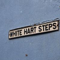
I took an extra-long break at lunchtime today as I'd taken the day off my normal day-job to do the accounts for my previous side-job, which is still generating paperwork, though not much in the way of money. This took me through some undiscovered bits of Cliftonwood, including Worlds End Lane, which unexpectedly leads to White Hart Steps. That's certainly not where I expected the end of the world to lead to...
More Cliftonwood
05 Dec 2020
Back to Cliftonwood for a wander that included some of the belle views of Bellevue Crescent and other bits of the easternmost part. Highlights included watching someone bump-starting an elderly Nissan Micra in the narrow confines of Bellevue Crescent.

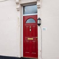
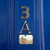
I'm not sure why this door in particular caught my eye. Maybe it was the lion, or the fact that it's number 42. However, talking to my friend Gary (whose house is also featured in this walk!) about One Mile Matt, I found out a fascinating tidbit: this house has a built-in pipe organ!
“Charismatic and eccentric” is certainly one way to describe a home for sale in Bristol that comes with an inbuilt pipe organ taking up much of one floor. The four-bedroom house has been owned by the same family for three generations and is now for sale for £500,000. Bristol24/7 understands that the house most recently belonged to a former church organist who who died last year just before her 99th birthday. Her husband built her the organ at their home on Cliftonwood Crescent in Cliftonwood so that she could practise at home.
I went to have a peep at the giant sinkhole that's opened up in Canynge Square—ironically, having recently discovered the gardens were public I'd had the (triangular!) square on my list to re-visit for a few days, but now there's no entrance to the gardens due to the danger. The area was well fenced-off for safety, but I tried to get a couple of photos from behind the barriers.
I also explored the area around Camp Road, an real melange of architectures, one of the most mixed-up areas I've seen in Clifton, in fact, and confirmed my friend Claire's suspicion that an earlier snap of a sign from Manilla Road was in fact for a fire hydrant. Nice.
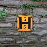
Not as old as the sign on the building that first caught my eye, but this modern hydrant sign must still be fairly old, as it's pre-metric: the hydrant is a 3" hydrant, 6 feet in front of the sign.
Another day, another coffee. I think I may have knocked a tiny footpath in Baltic Wharf from my list of leftover paths in the area, but mostly this walk was about getting out into the crisp February cold and enjoying the walk. On the way I posted a letter at 13 Dowry Parade (home of a surgeon called Willam Falls back 1830, according to Pigot's Directory of Gloucestershire...) and pondered the strange duality of Dowry Parade and Hotwell Road, then wandered through the Dowry Parade end of Cumberland Piazza, enjoying the clean lines of the glyph graff, before taking the causeway route past a Cumberland Basin empty of water but full of seagulls, to make my way south of the harbour.
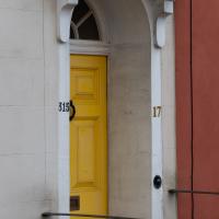
I went down to Dowry Parade to deliver a letter that had unaccountably been delievered here, a few streets away. It was only because the address as 13 Dowry Parade that I noticed this strange duality I'd not spotted before. The start of "Dowry Parade" has numbers in the three-digit range, because it's actually Hotwell Road, really. But a handful of them have both Hotwell Road numbers and their presumably-older Dowry Parade numbers. So, here's a snap of either/both of 315 Hotwell Road, or 17 Dowry Parade.
Clifton Village, including Oxford Place
15 Feb 2021
I've noticed Oxford Place as a tiny little side/back road I've overlooked on my wanders a few times. Today I decided to pop down and have a look, as well as taking a few general snaps of Princess Victoria Street, which I thought deserved more pictures, as it's basically my closest decent shops, and in the Beforetimes I'd visit the Co-Op up there all the time, as well as the cafes (you'll be missed, Clifton Village branch of Boston Tea Party, recently closed in favour of Eat a Pitta.)
I'm definitely becoming more familiar with the area through the One Mile Matt jaunts and associated reading. Today I didn't just think, "oh, I'll head home down that weird alleyway with the electrical substation in it"—no, I thought, "I'll head home down Hanover Lane", because I actually knew its name. And on the way back from there I nodded sagely to myself as I passed St Vincent's Road, knowing now which St Vincent it's likely to be (St Vincent of Saragossa) and also eyed up the modern flats on Clifton Vale and wondered if they might have been built on the site of the former Vauxhall Pleasure Gardens... I don't know all the answers, but at least I have some idea of the historical questions I'm interested in.
There's a village in Australia's Northern Territory called Cooinda, in Kakadu National Park.
Of Bridges and Buoys
04 Mar 2021
A trip to Imagine That coffee, so no fresh roads knocked off my list, but I stopped off to snap a couple of the engineering-related bits of the docks: the Campbell Buoy (used by P&A Campbell for mooring their paddle steamers) and Brunel's "other" bridge, the foot/horse swing bridge that now sits sadly disused in the shadow of the Plimsoll Bridge at Howard's Lock.
I headed to Bedminster to do a crossword with my support bubble today. On the way I delved into a couple of bits of Hotwells history, first of all snapping a "now" shot to go with a historical photo of Holy Trinity I happened across recently, and second of all to snap the Britannia Buildings.
The Britannia Buildings are a little strip of offices on a corner of the Hotwell Road. They've mostly been the headquarters of a cleaning company for years, but I've often wondered what this distinctive curve of offices, its ground floor standing proudly out from the upper floors, used to be. Well, after my last wander, where I poked about the landing stage just down the road, I found out! Researching the paddleboat company P&A Campbell I came across this nugget in The A-Z of Curious Bristol, by Maurice Fells (£):
The firm of P & A Campbell was the main steamer operator in the Bristol Channel, with its local headquarters in offices close to the Hotwells pier and overlooking the harbour at the Cumberland Basin. Campbell's named their offices Britannia Buildings, after one of the ships in their White Funnel Fleet.
So! Turns out the Britannia Buildings were named after a paddle steamer—you can see some pictures of Britannia here.
In related news, I've now bought three of Maurice Fells' local history books, and they were hand-delivered by the author on Sunday, a half-hour after I ordered them online (through a message exchange on Nextdoor!) Not even Amazon Prime has managed to deliver me anything that quickly...
I got interested in Bristol's medieval water supplies after poking around near Jacobs Wells Road and Brandon Hill. It was during that research I found out about a pipe that's still there today, and, as far as I know, still actually functioning, that was originally commissioned by Carmelite monks in the 13th century. They wanted a supply of spring water from Brandon Hill to their priory on the site of what's now the Bristol Beacon—Colston Hall, as-was. It was created around 1267, and later, in 1376, extended generously with an extra "feather" pipe to St John's On The Wall, giving the pipework its modern name of "St John's Conduit".
St John's on the Wall is still there, guarding the remaining city gate at the end of Broad Street, and the outlet tap area was recently refurbished. It doesn't run continuously now, like it did when I first moved to Bristol and worked at the end of Broad Street, in the Everard Building, but I believe the pipe still functions. One day I'd like to see that tap running...
There are a few links on the web about the pipe, but by far the best thing to do is to watch this short and fascinating 1970s TV documentary called The Hidden Source, which has some footage of the actual pipe and also lots of fantastic general footage of Bristol in the seventies.
On my walk today I was actually just going to the building society in town, but I decided to trace some of the route of the Carmelite pipe, including visiting streets it runs under, like Park Street, Christmas Street, and, of course, Pipe Lane. I also went a bit out of my way to check out St James' Priory, the oldest building in Bristol, seeing as it was just around the corner from the building society.
There are far too many pictures from this walk, and my feet are now quite sore, because it was a long one. But I enjoyed it.
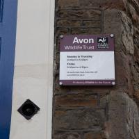
It's the home of the Avon Wildlife Trust now, but back in the day it was Brandon Hill Police Station. It's marked on maps as recent as the 1950s Bristol Town Plans. An interesting tidbit from Bristol Then and Now on Facebook:
One of the first police stations in Bristol, it was opened in 1836 - policemen from the station used the building housing the Jacob's Well as a bicycle store and many old bicycle lamp batteries were found in excavating the small entrance to the mikveh. The Police Station closed in 1967 and it is now the base of Avon Wildlife Trust.
I bumped into my friend Lisa in town during yesterday's wander, and we decided to have a wander today, too. We managed quite a long ramble, starting up through Clifton and nipping down Park Row to investigate the two tower blocks I'd noticed popping up behind Park Street yesterday, then took in a few roads I'd not managed to get to before, including cutting through the grounds of Bristol Grammar School.
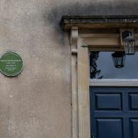
I have snapped this plaque before, but apparently I didn't look up the name. He designed the Wills Memorial Tower, one of Bristol's most significant landmarks, and one I snapped just yesterday.
A London Wander in Southville
10 Apr 2021
There's a bit of Southville that I've been meaning to get to for some time, where the streets seem to take some strong inspiration from London. There's a Camden Road that crosses with an Islington Road, and a Dalston Road, even an Edgeware Road. For me these names are more evocative than the rather more exotic names I passed by to get there—Sydney Row or Hanover Place, say, because I've actually been to the places in London. The last time I was in Islington I saw Monkey Swallows the Universe play at The Angel, and I can't think of Camden without remembering a gondola trip with my friend Tara where a cheery youth played Beatles music for us on a saz...
I really liked this little area, with its mostly well-kept pretty houses and hints here and there of the creative side of the residents. It's arty and down-to-earth at the same time, and I wouldn't mind living there, I think.
On the way there I got the chance to walk through Underfall Yard for the first time in a while, and on the way back I had my first take-away hot food for many months, grabbing some crispy fried squid from the excellent Woky Ko at Wapping Wharf.
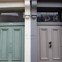
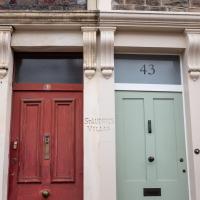
It's interesting that the houses share a name. I'm not sure I like the effect the owners have created by painting them in such dfiferent colours.