Tagged: pole
Ticking Off a Pocket of Paths in Leigh Woods
03 Jun 2022
I managed to go for a wander a while ago that was meant to finish off a little tangle of paths in Leigh Woods, or at the very least finish off my wandering of the Purple Path there. And I managed to miss doing either of those things through some kind of navigational incompetence.
Today I woke up with a bit of a headache, feeling a bit knackered as soon as I dragged myself out of bed, but at least with the energy to realise that I'd be better off (a) going for a walk in what looked likely to be the last of the Jubilee weekend sunshine than (b) moping around the flat until it started raining, at which point I could mope more thoroughly.
I had a look at my map, considered going to Ashton Court, but remembered that there was a music festival there today, and instead found these little leftovers of Leigh Woods and decided to have one more try at walking them.
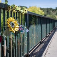
Opposite the exit from Leigh Woods on North Road.
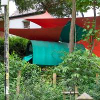
This may be an example of the rule that if a scrap of land in the South West sits unused for long enough, a twee AirBnb rental will spontaneously pop up on it.
A Quick Swing Past Ashton Court
05 Jun 2022
Another day not dissimilar to my last wander: I'm feeling a bit tired and rather than just moping around the house I thought I'd find some tiny bit of somewhere that I'd not yet walked and get outdoors. This time I headed for the Tobacco Factory Market in Bedminster, as I often do, but went the long way around via Ashton Court Mansion as I knew there were some footpaths and a small section of road I'd not ticked off up there. Finishing all the Ashton Court footpaths will be quite a long job, but you've got to start somewhere...
I did feel rather better by the time I got home, and, pretty much astoundingly given the weather forecast, managed to avoid the rain completely.
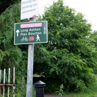
I like the sound of "Flax Bourton". I keep on meaning to dust off my bike; maybe a trip along there would be an interesting day trip. Might want to make sure I can still ride comfortably before I try a ten-mile round trip, though...
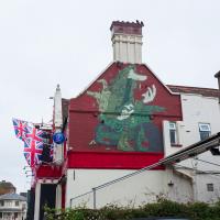
Pre-Upfest, as recently as April, Pikto's boy with the catapult still adorned the side of the Coopers Arms.
Not quite sure what to make of the replacement. It's much lower-contrast and less eye-catching, for me. Also, I'm so out of touch I have no idea if that's an original character or some famous pop-cuture reference.
Ahh, according to Natural Adventures it's "what looks like a Vaughn Bode Lizard, an Iconic character in the world of street art", and it's by an artist called Derm. I'd never heard of Vaughn Bodē or his Cheech Wizard and lizard apprentice, so it's not surprising this piece is going over my head. Probably more one for the real aficionados to appreciate.
I'm in the habit of going over to the Tobacco Factory Market on a Sunday. I think I've walked all the routes around that way, but as a Plimsoll Bridge swing let me cross the road to the far side of Brunel Way on my return journey and I took a couple of photos of the brownfield development at the old Ashton Gate Depot site I thought I'd call it a Wander and pop some photos up.
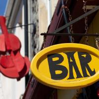
El Rincon is a long-established Spanish cafe/bar on North Street. The BAR sign always reminds me of the quirky typefaces used in things like The Pink Panther.
Nipping Up the Zig Zag to the Shops
19 Aug 2023
It's been a long while since I did one of these walks.
I'm thinking of finishing up the project by walking one or two last bits of road, thus being able to declare with all honesty that I've done my best to walk every public road within my mile (and quite a few alleyways besides.) As a prelude, and just because I felt like it, I decided to drag out the camera and GPS on this little wander to the local shops.
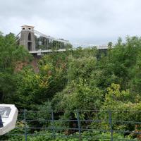
The reward at the top is the viewing platform of the Suspension Bridge, always busy with tourists.
I was actually planning to take an unexpected short-cut through a pub as an interesting little diversion on this wander, but sadly the pub was closed—I suppose before midday it's a bit of a reach to expect any pub to be open, even on a Saturday—so I headed for the shops instead. I'll have to do the short-cut trip one afternoon...
First I browsed the books at Rachel's & Michael's Antiques on Princess Victoria Street, where I bought CFW Dening's Old Pubs of Bristol as it mentions Hotwells a few times, then I grabbed my lunch from Parsons Bakery. There didn't seem to be anything new or interesting to snap along the way, so we'll now skip to the last couple of photos I took on my way home...