Tagged: pole
Alma Vale
06 Dec 2020
I wasn't really feeling it when I set out today, on my first car-assisted wander. By the time I'd parked on Alma Vale Road in Clifton it was just starting to rain and I picked my way about in quite a desultory way. It felt strange, as I was very familiar with the area because I'd walked through it hundreds of times when I worked at the top of Whiteladies Road, and used to walk up the hill from Hotwells and through Clifton to get there, and back again, every day.
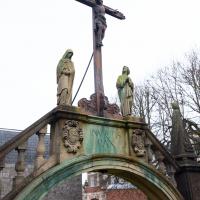
Then a complete coincidence seemed to make the change I'd been hoping for. I was standing taking a photo of Christ in the front garden of All Saints church when a couple of people walked out of the front door. I got talking with a lady I took to be part of the ministerial team, who invited me to come in and look around—something I'd always wanted to do on the morning commute. (I think we connected a bit when I recognised the name John Piper, who did the amazing windows—I learned about him while I was at Warwick, through his connections to Coventry Cathedral.
I left with much more of a spring in my step, wandered around the area a bit more, finally working out that the tennis courts I used to pass every morning are those of Clifton Lawn Tennis Club, and finally grabbing an excellent Hungarian sausage hot dog from the Budapest Cafe. I feel a lot better now than I did before I went out.
From Historic England:
War Memorial Calvary. 1928 by F C Eden commemorating the worshippers who gave their lives in the Great War, to which those from the Second World War have been added. Stone. Rounded arch on polygonal base, flanked by obelisks and supporting wooden Calvary cross surrounded by stone figures. An unusual and prominent memorial.
Rainy Clifton
13 Dec 2020
A long walk around Cliftonwood and Clifton with my friend Lisa, taking in some of the 12 Days of Christmas display at Queens Parade, picking up a take-away coffee from Pinkmans of Park Street, and poking our heads up against the glass of SS Peter and Paul Catholic Cathedral.
Cliftonwood and Clifton Village Lunchtime Stroll
14 Dec 2020
The lunchtime walk has been feeling a bit of a chore lately, especially as I only have an hour and have to keep a mental watch out for my "bingo" point or risk being late back. Today I went for a deliberately brief local walk and got home in time to have lunch on my sofa rather than while I was back at work.
It's interesting filling in the gaps in my Clifton Village knowledge, especially starting to "see" the bits I can't see, the negative spaces. The size of both Fosseway Court and the Bishop's House gardens (check out the latter on Google Maps for an idea) are both something I've noticed by just getting to know the areas around them. I may also have to walk into the driveway of the very well-hidden Nuffield hospital to get an idea of how big it is.
None of those are anything compared to the trick of hiding the gargantuan public school that is Queen Elizabeth's Hospital so well that I keep on forgetting it's there, until a glimpse of it from somewhere like Lower Clifton Hill reminds me about it, of course...
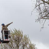
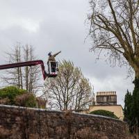
He seemed to be discussing the best pruning approach with someone on the ground, possibly whoever looks after maintenance at Fosseway Court. I think this tree may be in their garden, but it was hard to tell for sure.
To Bedminster
19 Dec 2020
Despite a mild headache, I enjoyed this wander over to Bedminster. The light was lovely, especially toward the end. I always enjoy the view down the streets south of North Street at this time of day/year, with the distant hills backdropping the Victorian terraces.
Sunday Bedmo
20 Dec 2020
A long meander around bits of Bedminster, from the river to the north to Winterstoke Road to the south, taking a few roads I've seen before, and a few I haven't. The Christmas decorations were an extra bonus.
Solstice Rain
21 Dec 2020
Despite the weather, Sarah and Vik and I wandered around Ashton Court a bit as the sun rose. Not that you could really tell. Sadly, the bit we wanted to watch the sunrise from was closed, because people hadn't been treating the deer with appropriate respect. Ah well, at least it was some exercise.
One of these kids is doing his own thing.
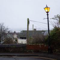
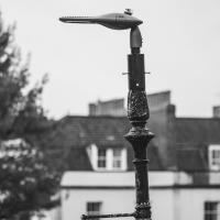
This light used to look like the other two. Apparently the head of it was taken away temporarily to be repaired and replaced by this objectively ugly bit of modern crap. The original hasn't been seen for more than a year.
I went to have a peep at the giant sinkhole that's opened up in Canynge Square—ironically, having recently discovered the gardens were public I'd had the (triangular!) square on my list to re-visit for a few days, but now there's no entrance to the gardens due to the danger. The area was well fenced-off for safety, but I tried to get a couple of photos from behind the barriers.
I also explored the area around Camp Road, an real melange of architectures, one of the most mixed-up areas I've seen in Clifton, in fact, and confirmed my friend Claire's suspicion that an earlier snap of a sign from Manilla Road was in fact for a fire hydrant. Nice.
A Promenade on New Year's Day
01 Jan 2021
I wandered along the gorge today and found the entrance to the disused Portnalls Number 1 railway tunnel of the Bristol Port Railway and Pier. The door was unlocked, but as soon as I opened it I felt a sense of current habitation and decided discretion was the best option. There's a lot of people homeless in Bristol at the moment, and they don't need disturbing. For the same reason, I've omitted posting some pictures of a little encampment somewhat off the beaten track of the new Zig Zag, where I reversed direction as soon as I realised I'd come across a current habitation of some sort.
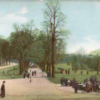
Up in Clifton it took me a little while to work out that the picture of the Promenade I was trying to reproduce was taken from the viewpoint I'd thought, it was just that the Alderman's fountain was moved from the top of Bridge Valley Road to the other side of the promenade in 1987, so trying to use it as my initial landmark wasn't very helpful!
Finally I swung past the Society of Merchant Venturers, who presumably still own most of Clifton, having bought the entire manor, including Clifton Down, in 1676, and I imagine aren't in much danger of running out of money. That's true to their motto: indocilis pauperiem pati is apparently from the Odes of Horace, and translates as "will not learn to endure poverty"...
The New Zig Zag runs up the gorge between Bridge Valley Road and the area known as "Fairy Glen".
This postcard is from somewhere between 1900 and 1920, courtesy of the Historic England archive.
This is the view I was trying to recreate -- note that the Alderman Proctor's Drinking Fountain is now on the other side of the promenade (see my photo, next), having been re-sited in 1988 after apparently causing problems for the traffic at the top of Bridge Valley Road.
Another day, another coffee. I think I may have knocked a tiny footpath in Baltic Wharf from my list of leftover paths in the area, but mostly this walk was about getting out into the crisp February cold and enjoying the walk. On the way I posted a letter at 13 Dowry Parade (home of a surgeon called Willam Falls back 1830, according to Pigot's Directory of Gloucestershire...) and pondered the strange duality of Dowry Parade and Hotwell Road, then wandered through the Dowry Parade end of Cumberland Piazza, enjoying the clean lines of the glyph graff, before taking the causeway route past a Cumberland Basin empty of water but full of seagulls, to make my way south of the harbour.
Clifton Village, including Oxford Place
15 Feb 2021
I've noticed Oxford Place as a tiny little side/back road I've overlooked on my wanders a few times. Today I decided to pop down and have a look, as well as taking a few general snaps of Princess Victoria Street, which I thought deserved more pictures, as it's basically my closest decent shops, and in the Beforetimes I'd visit the Co-Op up there all the time, as well as the cafes (you'll be missed, Clifton Village branch of Boston Tea Party, recently closed in favour of Eat a Pitta.)
I'm definitely becoming more familiar with the area through the One Mile Matt jaunts and associated reading. Today I didn't just think, "oh, I'll head home down that weird alleyway with the electrical substation in it"—no, I thought, "I'll head home down Hanover Lane", because I actually knew its name. And on the way back from there I nodded sagely to myself as I passed St Vincent's Road, knowing now which St Vincent it's likely to be (St Vincent of Saragossa) and also eyed up the modern flats on Clifton Vale and wondered if they might have been built on the site of the former Vauxhall Pleasure Gardens... I don't know all the answers, but at least I have some idea of the historical questions I'm interested in.
