Tagged: public-transport
Brief Jaunt to the not-so-Hot Well
13 Feb 2021
It's been very cold the last few days, so seeing as it was low tide at a convenient afternoon hour, I just wandered out to see if I could see the hot well steaming. I've been told that you sometimes can, on a cold day, but today, as with every other day I've tried, there was nothing in evidence.
It may be that the emergent spring has already filtered through too much cold river silt by the time it hits the surface these days, or even that it's running cooler than it used to. But perhaps I've just been unlucky.
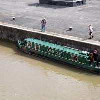
Quick Around-the-Harbour Wander with Lisa
20 Mar 2021
My friend Lisa was meeting another friend for a walk near the suspension bridge, so we fitted in a quick harbourside loop from my place first. We discussed gardening (we're both envious of the gardening skills of the Pooles Wharf residents; we can just about keep herbs alive, whereas they're growing heartily-fruiting lemon trees outdoors in England along with everything from bonsai to magnolias), cafes, work and architecture, among other things.
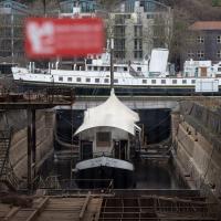
It's a floating cider bar, normally moored near Bristol Bridge, hence the name. It seems very small for the dry dock here. They once launched ships so big from here that one of them (MV Dumra) collided with Mardyke Wharf, opposite, with enough force to stave in the harbour wall and buckle the railway lines. Not much danger of that from the Apple, I'd think.
There's no date on the Dumra picture, but [she was completed in 1922, so I think that must bt the year the photo was taken. Unless they had to reel her back in, fix her and re-launch her.
A Longer-than-it-looks Walk With Lisa
06 Jun 2021
The track on the map doesn't tell the whole story of this walk with Lisa around and about Clifton, Berkeley Square, Brandon Hill and the harbourside, because the batteries on my GPS ran out while we were on the roof of Trenchard Street car park, it seems. Oh well. I think I did most of the area I was interested in finishing off around the University; there were only a few new bits around Brandon Hill that won't be on the track, and I can easily do them again.
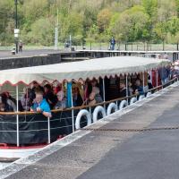
Still, technology woes aside it was a nice walk, albeit a bit warm for climbing all those hills, and sat on the harbourside watching the world go by for a while, too. It was good to see the Bristol Ferry Boats carrying people around again, especially.
Ticking Off a Few Streets in Bedminster
31 Oct 2021
There were only a few streets left to wander in the more residential bit of Bedminster, so I thought I should target those today. The streets themselves weren't that notable, though Balfour Road has a contrasting mix of old and new housing. I tried to snap a few more interesting things along the way there and back, snapping all three of the familiar bond warehouses, nipping onto North Street to find some new street art, and finding a few pumpkins for good measure. It is hallowe'en, after all...
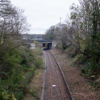
Just as well there wasn't a steam train running over it when half the path fell into the river, I suppose.
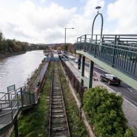
The more I research it, the more I find that Hotwells had far better transport links back in Victorian and Edwardian times than it has today. Along with buses that went to more useful places than the City Centre, there were trams, the funicular up to Clifton, the landing stage for paddle steamer services and two railway stations all within easy walking distance of me.
Today I took a day off work as preparation for doing the bookkeeping for my tax return1, and took a wander along to the site of what would have been my nearest station, Hotwells (or Clifton, as it started out in life), nestled in the shadow of the suspension bridge, the Bristol terminus of the Bristol Port Railway and Pier.
From there I wandered down the Portway, following the original line, until I got to the area around Sneyd Park Junction, where the tunnel from the slightly later Clifton Extension Railway joined up with this originally-isolated BPR line. Then I headed up to Clifton through the "goat gully" at Walcombe Slade, seeing the few above-ground bits of evidence of the tunnel (which is still in regular use) along the way.
It was a lovely day, and a good walk, and it was interesting to daydream of the times when I could have walked a few minutes from my flat down to Dowry Parade, caught a short tram ride to Hotwells Stations, and then headed from there to Avonmouth, perhaps even to board a transatlantic passenger service. The completion of the Clifton Extension Railway that linked the Avonmouth station with Temple Meads made relatively direct transatlantic travel from London via Bristol possible, with passengers travelling up from Paddington to Temple Meads, on to Avonmouth on the Clifton Extension Railway and Port Railway and Pier line, then perhaps catching a Cambpell's paddle steamer—which sometimes acted as tenders for large steamers—to a larger ship that was headed out for Canada, say.
1 I've learned that the best approach is to take two days off and deliberately do something that's not my bookkeeping on the first day, as otherwise I just inevitably end up procrastinating and feeling guilty on the first day no matter what. I have an odd brain, but at least I'm learning strategies for dealing with its strange ways as I get older...
2 Information mostly gleaned from Colin Maggs' The Bristol Port Railway & Pier and the Clifton Extension Railway, The Oakwood Press, 1975.
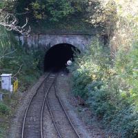
Well, we didn't quite see the far end, but seeing as we've seen the three ventilation holes, I thought it would be worth actually seeing some of the tunnel! This is the Clifton end, adjacent Clifton Down Station.
The tunnel is dead straight. You can, apparently, see right from one end to the other, though I don't think there's anywhere for a member of the public to stand that allows that view. Of course, in the days of steam, the view was mostly obscured by smoke from the trains themselves, and this exit had a succession of jury-rigged bell systems so that the driver would know when to apply the brakes to avoid overshooting the station, as it was hard to tell when they were about to emerge from the tunnel.
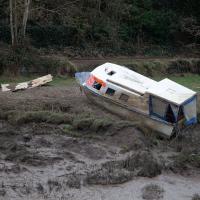
Bower Ashton is an interesting little area just south of the river from me—in fact, the Rownham Ferry used to take people over from Hotwells to Bower Ashton, operating from at least the twelfth century to around the 1930s.
It's a strangely contradictory little area, with a cluster of old and new houses sandwiched in between the busy A-roads and significantly more industrial area of Ashton and the bucolic country estate of Ashton court roughly east to west, and also between Somerset and Bristol, north to south.
I've been around here before, mostly poking around Bower Ashton's arguably most well-known bit, the Arts faculty campus of the University of the West of England, but I'd missed at least Parklands Road and Blackmoors Lane, so I initially planned just to nip across briefly and wander down each in turn. On a whim, though, I texted my friends Sarah and Vik in case they were out and about, and ended up diverting to the Tobacco Factory Sunday market first, to grab a quick flat white with them, extending my journey a fair bit.
To start with, though, I nipped to a much more local destination, to see something that you can't actually see at all, the Gridiron...
(I also used this wander as a test of the cameras in my new phone. I finally upgraded after a few years, and the new one has extra, separate wide and telephoto lenses compared to the paltry single lens on my old phone. Gawd. I remember when speed-dial was the latest innovation in phones...)
As-was. I'm standing on the bridge pictured in the main photo on the Wikipedia article, looking back to the A370 flyover that that photo was taken from.
As with Clifton Bridge Station, the next stop "down", there's not much to be seen these days.
Apparently there's some pressure to re-open the station as part of the MetroWest scheme, at which point I'd presumably be able to walk to a station that would get me on a train to Portishead on this old branch line, which would be a nice way of going on a day out. I've hardly ever been to Portishead, but I quite enjoyed the couple of trips I've taken there... I won't hold my breath, though.
Wikipedia notes that it was renamed temporarily in 1914 to Bristol International Exhibition, traces of which we've previously seen—it was the halls being constructed of white plasterboard and mouldings made from fibre and gypsum that led to its nickname of "White City", which is the name of the allotments that stand there now.
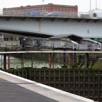
A Swing of the Plimsoll Bridge
24 Apr 2022
I was originally going to head over to the Ashton area to see if I'd missed any bits around the football stadium—and also to grab some lunch from the Tobacco Factory Market—but in the end I got a little distracted by having accidentally chosen exactly the right time to see the Plimsoll Bridge swing on one of the first busy days of Spring, where a lot of pleasure trips tend to head out down the Avon (and possibly the New Cut) from Hotwells.
In the end I mostly snapped that, and just a couple of photos from the Ashton area where I grabbed some lunch but didn't do any new exploring.