Tagged: relief
Little Clifton Village Details
09 Nov 2020
I like The Paragon as a terrace, especially the bowed porches. On the other side of the road, a house attic has a stone lion surrounded by rocaille leaves, according to its listing.
I also love the detail of the arrows in the wrought iron of The Mall's balconies. Today I discovered Westfield place, a road I'd never encountered that runs up to the rear of the Coronation Tap. (It's a famous local cider pub, but I've only been in a couple of times. I'm more of a beer man.)

Number 16 The Paragon lies on the other side of the street from the main terrace. It's grade II listed and has "a raised shield to the attic with a lion surrounded by rocaille leaves".
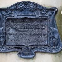
I was particularly intrigued by "MARIA EDGEWORTH his aunt visited here". It's this Maria Edgeworth, a prolific writer, apparently. "She was the second child of Richard Lovell Edgeworth (who eventually fathered 22 children by four wives)", so I imagine Thomas Beddoes had quite a few aunts...
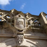
Clifton Village: Jesus and the Tympanum
12 Nov 2020
My goal is walk down every public road within a mile of me; sometimes it's not easy to tell what's public. I've passed the turning for Cornwallis Grove a thousand times, but never had a reason to venture down it, and although the street signs at the end seem to be council-deployed and I didn't spot any "private" signs, it's a gated road and definitely feels private.
Gathering all the white middle-class privilege I could muster, I wandered down and was rewarded with the sight of a Victorian pump, a statue of Jesus, and from the end of the road, a view of a private garden that once belonged to a private girls' school.
The Cornwallis House history page says:
In the early 20th century the house, together with Grove House, became a Catholic school, St Joseph’s High School for Girls. The Congregation of La Retraite took over the school in 1924, with the nuns living in Grove House while the schoolrooms were in Cornwallis House. The headmistress was Mother St Paul de la Croix (Sister Paula Yerby). By the 1970s La Retraite High School had around 700 pupils.
It closed in 1982 and the building was bought by Pearce Homes Ltd (now part of Crest Nicholson) who developed it into 21 flats. Grove House next door was bought by the Bristol Cancer Help Centre, and was later converted into flats in 2007.
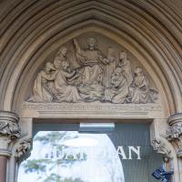
A United Reform chapel, now flats, naturellement. Christ is preaching in the tympanum
In which our intrepid hero levels up.
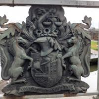
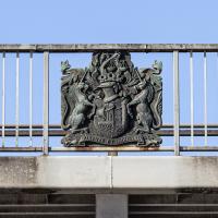
Most of Bristol's bridges have the coat of arms on them. Not quite sure what's going on with the snake.
A long ramble, starting with trying to find the Hot Well of Hotwells and leading up the side of the Avon Gorge to the Downs and then through Clifton for coffee.
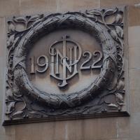
Not sure whose initials those are, but this is The Ivy, Clifton, formely NatWest bank, on the corner of The Mall and Caledonia Place. The listing says of 32-44 Caledonia Place, "he left-hand end pair rebuilt as one in 1922 to form a bank", and mentions 'the monogram "NUP"'
Prince's Lane
06 Jan 2021
The International Grotto Directory website says:
Prince’s Lane might have been one of the original ancient tracks from Hotwells to Clifton, in the Avon Gorge. The site later formed part of Rownham Woods which comprised some thirteen acres. By the end of the 18th century and the early 19th century, the Society of Merchant Venturers granted to Samuel Powell a building lease, for The Colonnade (1786), St. Vincent’s Parade (1790), Prince’s Buildings (1796), and Rock House. Rock House is generally considered to be the oldest surviving building associated with the Hotwell (see Chapter 20). John Power conveyed part of the woods to William Watts for the construction of Windsor Terrace (1790-1808).
The above development of the Avon Gorge cleared Rownham Woods, and created a triangle of land on the north side of the gorge, that became enclosed as a result, by Mansion Houses, whose garden walls all entered on to Prince’s Lane. The Lane started at the bottom of the gorge, at the base rock of Windsor Terrace, and came out half way up Sion Hill. It is clearly shown as a public footpath, dotted with trees, in Ashmead’s map of 1828. Some of the gardens were quite steep in parts and therefore, had to be terraced, because of the gradient of the gorge.
I've passed Prince's Lane literally thousands of times in my life, every time I've walked past the Avon Gorge Hotel, which itself started (in 1898) as the Grand Clifton Spa and Hydropathic Institution and pumped water up from the Hot Well for its hydropathic treatments. I've never actually ventured down it until today, or at least nothing like as far down it as I did this afternoon—I may have poked my head around the back of the hotel to see the original pump rooms at some point in the past.
This was a great wander, though it does very much feel like a private road, and frankly I may have been pushing my luck a bit by winding my way between the astoundingly big back gardens of the houses of some presumably very wealthy Cliftonites, but I felt vaguely justified in exploring the history of one of the oldest footpaths in my part of Bristol...
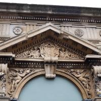
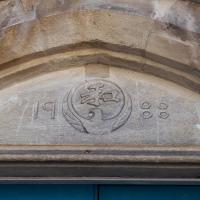
"Built 1894, designed by Philip Monro for Sir George Newnes, the promoter of the scheme", hence the GN in the pediment. He also funded the Clifton Rocks Railway, apparently.
Mirror Maze
10 Jan 2021
Went for a wander with my friend Lisa—the current lockdown rules seem to be that one local walk for exercise per day with a maximum of one person not in one's "bubble" is fine—up to the University of Bristol area right at the edge of my one-mile perimeter to see the Jeppe Hein Mirror Maze, among other things. On the way we mused about Merchant Venturers, the slave and tobacco trades, and dating in the time of Covid.
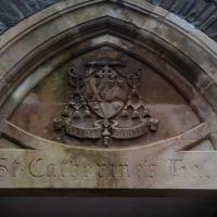
Faith and fortitude, presumably. Seems to be the back door to the yard behind the modern office building St Catherine's Court, apparently Clifton's only Grade "A" office building, according to their blurb.
According to Bristol and Region Archaeological Services, the builder of the Pro Cathedral up the hill first tried to build the Pro Cathedral, ran into quite a lot of difficulties caused by land slippage, and went bankrupt. In the meantime, however, he managed to put up a small chapel to St Augustine of Canterbury. Then (in 1848) a convent and schoolhouse were added, and a group of Dominican nuns devoted to St Catherine of Sienna moved in, hence Catherine's Court.
St Catherine is patron saint of Europe, among other things.
In Between
06 Feb 2021
A lovely walk in the early spring sunshine with my friend Lisa. We headed directly for Jacobs Wells Road, to start off around the scene of one of our earlier walks, but this time took in Jacobs Wells from QEH upward, stopping to snap some photos of a Bear With Me, some interesting areas between Park Street and Brandon Hill including a peculiarly quiet enclave with a ruined old build I'd never found before, then crossed the Centre to grab take-away pies from Pieminister (I had the Heidi Pie) and head back to my place down the harbourside.
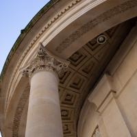
Well, given who occupies this place, you'd expect good masonry work. This is the home of the Freemasons' Provincial Grand Lodge of Bristol. The inside is meant to be pretty special, too, but sadly I missed the last open day. (Not kidding; the hall opens up to visitors on Bristol's popular Open Doors days)
Very Brief Hotwells Wander
18 Feb 2021
Really just a quick loop of the Cumberland Basin. I was going to go further, and it was a nice early spring day, but I hadn't slept that well and I wasn't really in the mood. Ah well. Not every walk is great. At least I got out of the house for a bit.
I'm glad my friend Lisa joined me today; she drove in from Shirehampton and told me that the Portway was looking rather lovely, so we set off that way. She's also braver than I am when it comes to doing urbex stuff, so this was just the opportunity to take a peek into the Portnalls Number One Railway Tunnel/Bridge Road Deep Valley Shelter whose entrance I'd found on a previous wander.
It was definitely dark and spooky and impressively big, with a side tunnel that Lisa explored that leads to a little door I don't think I've previously noticed on the side of the Portway. I didn't get many photos—even my astoundingly powerful little torch (£) didn't do much to light things up, and you're not going to get much joy hand-holding a camera in that darkness—but I did shoot a little video, which I might edit and add later.
After plumbing the bowels of the earth, we went up Bridge Valley Path to Clifton, explored some bits around the College and Pembroke Road, then came home via Foliage Cafe for coffee. Nice.
John Carr's Terrace
16 Mar 2021
I wanted a nice simple lunch-hour walk that took me past a cafe today, and I managed to find the perfect road to knock off my list of targets to do it. Situated just off Jacobs Wells Road, right next to Queen Elizabeth's Hospital, John Carr's Terrace, and Rosebery terrace above it, which I'd completely forgotten existed, are a little cul-de-sac that many Bristolians will have wandered past a thousand times without ever seeing.
There's a reason it's next to QEH:
Known traditionally as "The City School", Queen Elizabeth's Hospital was founded by the will of affluent merchant John Carr in 1586, gaining its first royal charter in 1590.
John Carr's terrace itself isn't much to write home about, architecturally, but I like the secluded feel of it, and I really liked Rosebery Terrace with its little houses, commanding position and friendly, slightly tumbledown feel.
On the way home I popped into Foliage Cafe for a coffee and a very pleasant nutella and banana pastry, then walked home past the refurbishment of the old Thali Cafe into a new and interesting clinic...
Among other things in its colourful history, the former Brandon Methodist Church was, for a while, the Japan Arts Centre, which probably explains this detail from its tympanum. I remember walking past when it had big adverts outside for martial arts. They used to teach Judo, Aikido and Karate, I think.