Tagged: repairs
One Albermarle Row, Granby Green and... People
12 Mar 2021
I was browsing some historical photos the other day, and came across "Rear of Unspecified House" in the Bristol Archives' John Trelawny Ross collection, and immediately recognised it as being the back of 1 Albermarle Row, just around the corner from me. I've not had much time to research the history of this odd little addition to Albermarle Row, or what happened to 1-4 Cumberland Place, number 4 of which used to be attached to the side of 1 Albermarle Row, but it was interesting to look at old maps for a few minutes and work out what used to be where.
That all connects with the little local bit of land at Granby Green, too, as it used to be numbers 1-3 Cumberland Place. There was something of a planning battle over Granby Green, and I've included an old edition of Hotwells & Cliftonwood News that I found online, a copy of which would have been popped through my letterbox at the time.
I was also inspired by some old pictures of Hotwell Road to try to put a few more people in my pictures, though I set my pre-focus a couple of extra metres out from normal to make sure I didn't get too close to anyone!
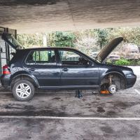
That seems to be a driveshaft flopping out of the wheel arch at the front, so I guess he's doing more than changing his tyres. This is probably a sensible place to work on your car on a rainy day -- sheltered, lots of space, decent light, nice and level. Plus I think it's the Lockside Car Park and I reckon theyr'e closed for lockdown.
Mokoko
26 Oct 2020
A dash around the harbourside to see if I can get to Mokoko and back in my lunch hour.
This was my first wander and I was still getting the hang of the technology. I managed to record only part of the way back on my GPS, by the looks of it, so I've had to bodge things a bit to pick up the photos, which is why there are photos in places the track doesn't reach!
I also need to fix a few technical things including managing my photo timezones more carefully. This wander was the day after the clocks went back for winter, and I think my camera may still have been in BST, which may not have helped me tie things up. Need to do a bit of research into how my cameras, Lightroom and the code I'm writing on this website handle BST and GMT, but at least I have until the last Sunday in March before things get urgent, I think...
Fresh Fields
17 Oct 2021
For the first time in a while, I had the time and energy to go further afield and knock off some new roads from my "to do" list. I headed through the first Hotwells Festival to Ashton and Bedminster to cross off a few of the suburban roads south of North Street.
First, though, I decided to try to reproduce an old photo of the now-demolished Rownham Hotel just around the corner from where I live...
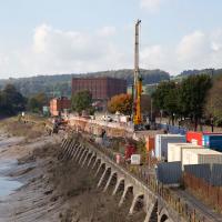
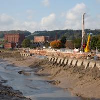
Apparently the repair of the Chocolate Path itself is now underway here. I won't hold my breath. Shame, as it's within my mile and one of my favourite walks and I've had no chance to walk down it since long before I started this little project.
To give you an idea of what it's like down on the path, here's a photo from 2017 from behind where I'm standing on Vauxhaull Bridge here.
An Evening Wander to the Gallows
06 Apr 2021
I'd originally intended just to pop up to the area around Alma Road, where I'd missed a few streets on earlier wanders. It was such a nice evening, though, I decided to extend my walk up to the very top of Pembroke Road, just outside my one mile radius, to take a few snaps of something intriguing I'd found in my researches.
I've driven, walked and jogged past the little triangle of land at the top of Pembroke road a great deal in my time in Bristol, but I didn't know that it used to be the site of a gibbet, in fact that the road itself there used to be called Gallows Acre Lane. According to the Durdham Down history trail, by Francis Greenacre (an excellent name for a Downs researcher!) among other sources:
...it was below this quarry near the top of Pembroke Road, once called Gallows Acre Lane, that a gibbet stood. It was sometimes occupied by those who had committed robberies on the Downs and was last used in 1783 to hang Shenkin Protheroe for the murder of a drover. Stories quickly spread that he descended from the gibbet at midnight every night and stalked through Clifton. Such was the alarm that his body was cut down
and buried.
Also very close to this little triangle of land was one of the gates of the extensive turnpike system...
Anyway. Along the way I encountered a wooden tortoise and a real squirrel, among other things. It was a good walk, and more light in the evenings means I can move my wanders out of the ticking countdown clock of work lunch-hours and be a bit more leisurely.
A London Wander in Southville
10 Apr 2021
There's a bit of Southville that I've been meaning to get to for some time, where the streets seem to take some strong inspiration from London. There's a Camden Road that crosses with an Islington Road, and a Dalston Road, even an Edgeware Road. For me these names are more evocative than the rather more exotic names I passed by to get there—Sydney Row or Hanover Place, say, because I've actually been to the places in London. The last time I was in Islington I saw Monkey Swallows the Universe play at The Angel, and I can't think of Camden without remembering a gondola trip with my friend Tara where a cheery youth played Beatles music for us on a saz...
I really liked this little area, with its mostly well-kept pretty houses and hints here and there of the creative side of the residents. It's arty and down-to-earth at the same time, and I wouldn't mind living there, I think.
On the way there I got the chance to walk through Underfall Yard for the first time in a while, and on the way back I had my first take-away hot food for many months, grabbing some crispy fried squid from the excellent Woky Ko at Wapping Wharf.
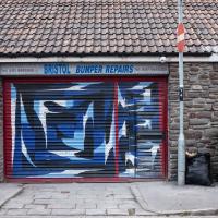
I've actually looked this place up with a view to getting a bumper repaired. Apparently he's very good.
Nothing New
02 Dec 2020
This may be the very first time I've gone for a One Mile Matt wander and not actually gone down any new roads, trod any new steps. I just wanted a coffee, frankly, so I went the same old way to Imagine That in the marina and back again.
