Tagged: sculpture
Outside the Zone
01 Nov 2020
This started as a little local walk with my friend Lisa, but when we randomly met my friends Sarah and Vik at Ashton Court, turned into joining them for a very long wander out to Abbots Leigh Pool. Most of this was well outside my one-mile radius but it was a lovely walk.
In which our intrepid hero levels up.
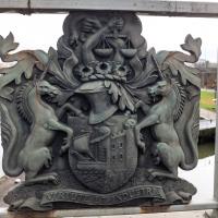
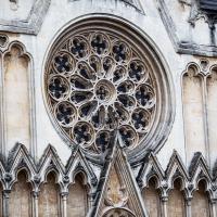
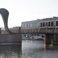
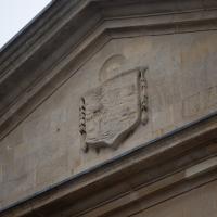
Most of Bristol's bridges have the coat of arms on them. Not quite sure what's going on with the snake.
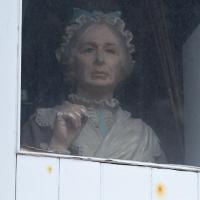
Clifton Village Mini Wander
20 Nov 2020
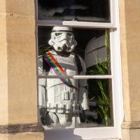
Just a quick wander up the hill to get a flat white from Twelve. I really enjoyed the spooky mannequin (?) in the window.
Bedmo and Ashton Court
21 Nov 2020
A rather more wide-ranging weekend wander with Sarah and Vik, taking in some mock Tudor bits of Bedmo (I should note that I've subsequently been corrected to "Bemmie", but I'm an outsider and have been calling it "Bedmo" for short for decades...), a chunk of Ashton, a path up Rownham Hill called Dead Badger's Bottom(!), The Ashton Court estate, a bit of the UWE campus at Bower Ashton, and some of the Festival Way path.
Up for the flu jab
21 Nov 2020
A trip up the hill to get my winter flu jab. I'm not sure I really needed it this year, what with avoiding Covid—I haven't had so much as a sniffle in more than a year—but seeing as they offered... Instead of the doctor's surgery on Pembroke Road, they'd taken over Christ Church, presumably to give more room and ventilation for the necessary social distancing at the moment. As usual, it was their typically efficient operation, and I was in and out in about three minutes.
On the way there and back I snapped as much as I could, but I wanted to be home in time for the first online Times Crossword Championship. As it turned out, I needn't have bothered, as the technology at the Times couldn't keep up with the demand from competitors, and their system just collapsed under the weight of page-views. They tried again the day after, and it collapsed just as badly. Maybe next year...
This wander is split into two parts, as I turned my tech off to go into Christ Church for my jab. The walk home can be found over here.
Avoiding the Accounts
26 Nov 2020
I took the day off my day job to do my accounts—or at least do enough bookkeeping to send them to my accountant. I hate doing the books. I woke up late, tired and with a headache and decided to bunk off for a walk around Cliftonwood, Clifton Village and Clifton instead, taking in a couple of good coffees along the way. Thanks, Foliage Café, and Twelve for the flat whites.
The Long Lunchtime at the End of the World
27 Nov 2020
I took an extra-long break at lunchtime today as I'd taken the day off my normal day-job to do the accounts for my previous side-job, which is still generating paperwork, though not much in the way of money. This took me through some undiscovered bits of Cliftonwood, including Worlds End Lane, which unexpectedly leads to White Hart Steps. That's certainly not where I expected the end of the world to lead to...
A long ramble, starting with trying to find the Hot Well of Hotwells and leading up the side of the Avon Gorge to the Downs and then through Clifton for coffee.
More Cliftonwood
05 Dec 2020
Back to Cliftonwood for a wander that included some of the belle views of Bellevue Crescent and other bits of the easternmost part. Highlights included watching someone bump-starting an elderly Nissan Micra in the narrow confines of Bellevue Crescent.
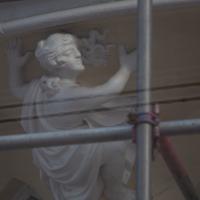
Well, she's a decorative figure supporting something. But not truly a caryatid, I feel. She also strongly reminds me of Stephen Fry.
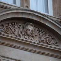
The third in a trio of unusual faces, this fella's been catching my eye from a high point on Princes Buildings for years.
Alma Vale
06 Dec 2020
I wasn't really feeling it when I set out today, on my first car-assisted wander. By the time I'd parked on Alma Vale Road in Clifton it was just starting to rain and I picked my way about in quite a desultory way. It felt strange, as I was very familiar with the area because I'd walked through it hundreds of times when I worked at the top of Whiteladies Road, and used to walk up the hill from Hotwells and through Clifton to get there, and back again, every day.
Then a complete coincidence seemed to make the change I'd been hoping for. I was standing taking a photo of Christ in the front garden of All Saints church when a couple of people walked out of the front door. I got talking with a lady I took to be part of the ministerial team, who invited me to come in and look around—something I'd always wanted to do on the morning commute. (I think we connected a bit when I recognised the name John Piper, who did the amazing windows—I learned about him while I was at Warwick, through his connections to Coventry Cathedral.
I left with much more of a spring in my step, wandered around the area a bit more, finally working out that the tennis courts I used to pass every morning are those of Clifton Lawn Tennis Club, and finally grabbing an excellent Hungarian sausage hot dog from the Budapest Cafe. I feel a lot better now than I did before I went out.
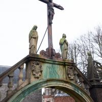
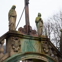
From Historic England:
War Memorial Calvary. 1928 by F C Eden commemorating the worshippers who gave their lives in the Great War, to which those from the Second World War have been added. Stone. Rounded arch on polygonal base, flanked by obelisks and supporting wooden Calvary cross surrounded by stone figures. An unusual and prominent memorial.