Tagged: winter
A Constitutional to Burwalls and Back
21 Dec 2021
The recent lack of posts here is mostly due to my feeling very run down following having a couple of wisdom teeth extracted. Having had an emergency appointment yesterday1, hopefully I'll be on the mend now, though it does mean I'm on the kind of antibiotics where you can't touch alcohol for the whole of the Christmas period. I have tried to keep myself a little distracted from the pain by working on the nuts and bolts of this website—you should notice that the front page loads rather faster now than it used to, and that there's a shiny new statistics page that I'll probably be continuing to work on. Oh, and you should find that the tags below the photos are now clickable and will take you to a page of all other wanders that have photos with the same tag.
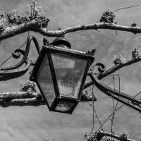
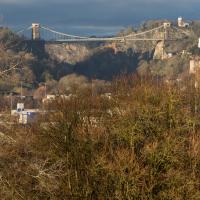
Today I felt like I needed to drag myself out of the house, but I didn't want to go too far, and I needed to get to the Post Office up in Clifton Village to post a Christmas card (spoiler for my parents: it's going to be late. Sorry.) As luck would have it, idly looking at the map I spotted that I'd missed off a section of Burwalls Road in the past, and that's basically one of the long-ways-round to Clifton Village, crossing the river to Rownham and walking up the hill on the Somerset side before coming back across the Suspension Bridge.
As I was heading for Burwalls Road I decided to make Burwalls itself the focal point of the walk, but unfortunately the mansion grounds are private and the place is hard to snap. Still, at least it gave me a destination. Burwalls was the mansion built by Bristol press magnate Joseph Leech, who I've mentioned before after buying a vintage book he wrote on a previous wander. There's a good article about the house on House and Heritage which has some photos from angles I couldn't ever get to. (Well, maybe with a drone, but it seems like the kind of area where they may be kitted out for clay pigeon shooting, so I probably wouldn't risk it.)
1 My dentist admitted that she probably needed to keep her internal monologue a bit more internal after we started the appointment with her staring into my mouth and immediately saying, "oh, *that's* weird." These are words one doesn't want to hear from a medical professional.
I was just about starting to feel better—the antibiotics seemed to have kicked in for my dental issues, and it had been some days since I'd left the house, and I was at last starting to get itchy feet. So, a wander. But where? Well, there were a few industrial bits near Winterstoke Road in the Ashton/Ashton Vale areas of Bristol that needed walking. I knew they were likely to be quite, well, unattractive, frankly. So why not do them while I wasn't feeling exactly 100% myself? Maybe it would fit my mood. Hopefully you're also in the mood for a bit of post-industrial wasteland, for that's what some of this feels like...
Then, at the last minute, I thought again about the Bristol International Exhibition—I've got a book about it on the way now—and that gave me another goal, which could just about be said to be in the same direction, and I decided to walk significantly further than my normal 1-mile limit and try recreating another historical photo...
Sadly I don't know much about the Ashton area; it's just on the edges of my mile and I rarely have cause to go there. It's brimming with history, I'm sure: the whole South Bristol area rapidly developed from farmland to coal mines to factories to its current interesting mixture of suburbs and industrial work over the last few hundred years. As a more working class area less attention was paid to it by historians, at least historically-speaking, than the Georgian heights of Clifton, and much of it has been knocked down and reinvented rather than listed and preserved. I see here and there some of this lack is being addressed, but I'm afraid I'll be very light on the history myself on this wander, as most of my usual sources aren't throwing up their normal reams of information as when I point them at Clifton, Hotwells or the old city.
I did take a lot of slightly different angles, clambering around on the slippery slopes of Bedminster Down and having the occasional entanglement with trees. I think this shows pretty much the same view as the historical photo, or at least as close as you can get by wandering around on the ground in about the right place today.
It was nice to be able to find it, and I've never walked to Bedminster Down before. And it's a nice palate cleanser after all that rather dreary industrial stuff, anyway...
And that's the note I'll leave things on, as it was already getting a bit dark for photography, so I mostly plodded my weary way home without any further snapping. At more than 9km it's not my longest wander ever, but it's about twice as long as the average, so I may have overdone it...
I mostly went out to hang out with my friends Sarah and Vik in Bedminster, but along the way I thought I'd take a closer look at something a little nearer home: the last crossing point of the Rownham Ferry.
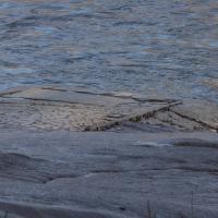
Now the tide's lower, we can see the end of the slipway we looked at earlier poking out from the Somerset side. According this article from the Bristol & Avon Family History Society:
In 1793 the ferry was identified as being used by many passengers to "cross the river at Rownham ferry and walk to the sweet and wholesome village of Ashton to eat strawberries and cream"
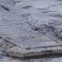
Looks like the stones at the bottom corner were replaced with some simple poured concrete with grip lines drawn across it at some point.
Easter Monday Gardens and Flowers
18 Apr 2022
I didn't really set out with a theme of flowers and gardens in mind for this walk. I just fancied heading up to Clifton Village to get lunch. As it turned out, though, Spring was springing, so a minor theme emerged as I started off with the graveyard flowers of Hope Chapel and wandered up to see the beginnings of the new wildflower garden at Clifton Hill Meadow.