Tagged: wood-stain
Gothic Revival
08 Dec 2020
I had a chance to dash down a few new roads during my lunchtime jaunt today. My favourite feature was 7 Wetherell Place, at the corner of Frederick Place, one street behind the University of Bristol Students' Union building. Apparently I'm a sucker for gothic revival, which seems appropriate for this little project, which is reviving my interest in the local area.
The listing starts "1860. By JA Hansom. For himself".
Bedminster, Ashton, Ashton Court sunset walk
12 Dec 2020
A walk with Sarah focusing on Ashton and the surrounds, taken on a day with really nice light around sunset. Just what I needed.
Drained Basin
15 Dec 2020
On the down side, I got to Bedminster and found long enough queues at both Mark's Bread and Hopper Coffee that I gave up on the idea of buying a drink and a pasty (from the former) or a mince pie flapjack (from the latter.) On the up side, I got to take some pictures of Cumberland Basin being drained and sluiced out, part of its regular maintenance cycle.
I went to have a peep at the giant sinkhole that's opened up in Canynge Square—ironically, having recently discovered the gardens were public I'd had the (triangular!) square on my list to re-visit for a few days, but now there's no entrance to the gardens due to the danger. The area was well fenced-off for safety, but I tried to get a couple of photos from behind the barriers.
I also explored the area around Camp Road, an real melange of architectures, one of the most mixed-up areas I've seen in Clifton, in fact, and confirmed my friend Claire's suspicion that an earlier snap of a sign from Manilla Road was in fact for a fire hydrant. Nice.
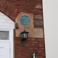
Given the dates, this must be the Beryl Cook, though her Wikipedia entry doesn't mention her living in Bristol.
Saint Vincent's Spring
28 Dec 2020
Fractionally outside my one-mile zone, but I got curious about Saint Vincent's spring, whose last remnants you can see in a defunct drinking fountain on the Portway. Along the way I passed Gyston's cave, sometimes called St Vincent's cave, in the sheer wall of the gorge. It's now accessible by a tunnel from the observatory—I tried it about twenty years ago, I think, and still recall the vertiginous moment of looking down from the protruding balcony and realising that you could see straight through the grille floor to the drop below—but from what I can work out the tunnel is relatively recent. Before the tunnel was dug it was accessible only by access across the cliff face, which must have been even more terrifying.
This cave was first mentioned as being a chapel in the year AD 305 and excavations, in which Romano-British pottery has been found, have revealed that it has been both a holy place and a place of refuge at various times in its history.
A few different sources say that the cave became a hermitage and chapel to St Vincent following Bristol's early trading in Iberian wines; St Vincent of Saragossa is Lisbon's patron saint, and a lot of nearby things bear the name.
I'm not sure where the crossover of Vincent and Ghyston happens, though. On the giants Goram and Vincent (or Ghyston), Wikipedia says:
The name Vincent for one of the giants rests on the fact that at Clifton, at the narrowest point of the Avon Gorge, there was formerly an ancient hermitage and chapel dedicated to St Vincent, at or near the present cave in the cliff-face which bears his name. Another (apparently modern) version of the story calls the Clifton giant Ghyston, which is in fact the name, of obscure origin, for the whole of the cliff-face of the Avon Gorge at least as early as the mid-fifteenth century, in the detailed description of the Bristol area by William Worcestre. The place-name was personified to produce the giant's name. Vincent's Cave is called Ghyston cave or The Giant’s Hole in an article in the July 1837 issue of Felix Farley’s Bristol Journal.
In my research on the original Hot Well House, I've seen quite a few contemporary paintings which state their viewpoint as "from St. Vincent's Rock", so in the 16th century it seems the cliff-face name was typically St Vincent Rock rather than Ghyston's Rock, perhaps.
I am, as you can tell, no historian!
On the way, I also wandered around the base of the popular climbing area, which I think is the site of the old Black Rock quarry.
...but more to the point, don't hoick you table into the river so it washes up on the banks by the Portway. Who knows where this came from...
Mirror Maze
10 Jan 2021
Went for a wander with my friend Lisa—the current lockdown rules seem to be that one local walk for exercise per day with a maximum of one person not in one's "bubble" is fine—up to the University of Bristol area right at the edge of my one-mile perimeter to see the Jeppe Hein Mirror Maze, among other things. On the way we mused about Merchant Venturers, the slave and tobacco trades, and dating in the time of Covid.
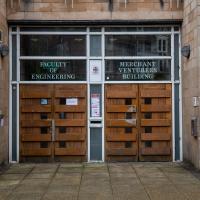
Interesting to think that if I'd read CS at Bristol rather than Warwick I'd have been doing it in the Merchant Venturers' building. Though I suppose I don't know where Bristol CS was in 1991. Pretty sure they've already knocked the old CS department down at Warwick, but then they always were quite cavalier about the buildings there.
In Between
06 Feb 2021
A lovely walk in the early spring sunshine with my friend Lisa. We headed directly for Jacobs Wells Road, to start off around the scene of one of our earlier walks, but this time took in Jacobs Wells from QEH upward, stopping to snap some photos of a Bear With Me, some interesting areas between Park Street and Brandon Hill including a peculiarly quiet enclave with a ruined old build I'd never found before, then crossed the Centre to grab take-away pies from Pieminister (I had the Heidi Pie) and head back to my place down the harbourside.
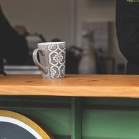
Another day, another coffee. I think I may have knocked a tiny footpath in Baltic Wharf from my list of leftover paths in the area, but mostly this walk was about getting out into the crisp February cold and enjoying the walk. On the way I posted a letter at 13 Dowry Parade (home of a surgeon called Willam Falls back 1830, according to Pigot's Directory of Gloucestershire...) and pondered the strange duality of Dowry Parade and Hotwell Road, then wandered through the Dowry Parade end of Cumberland Piazza, enjoying the clean lines of the glyph graff, before taking the causeway route past a Cumberland Basin empty of water but full of seagulls, to make my way south of the harbour.
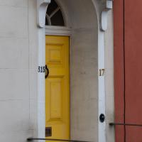
I went down to Dowry Parade to deliver a letter that had unaccountably been delievered here, a few streets away. It was only because the address as 13 Dowry Parade that I noticed this strange duality I'd not spotted before. The start of "Dowry Parade" has numbers in the three-digit range, because it's actually Hotwell Road, really. But a handful of them have both Hotwell Road numbers and their presumably-older Dowry Parade numbers. So, here's a snap of either/both of 315 Hotwell Road, or 17 Dowry Parade.
Clifton Village, including Oxford Place
15 Feb 2021
I've noticed Oxford Place as a tiny little side/back road I've overlooked on my wanders a few times. Today I decided to pop down and have a look, as well as taking a few general snaps of Princess Victoria Street, which I thought deserved more pictures, as it's basically my closest decent shops, and in the Beforetimes I'd visit the Co-Op up there all the time, as well as the cafes (you'll be missed, Clifton Village branch of Boston Tea Party, recently closed in favour of Eat a Pitta.)
I'm definitely becoming more familiar with the area through the One Mile Matt jaunts and associated reading. Today I didn't just think, "oh, I'll head home down that weird alleyway with the electrical substation in it"—no, I thought, "I'll head home down Hanover Lane", because I actually knew its name. And on the way back from there I nodded sagely to myself as I passed St Vincent's Road, knowing now which St Vincent it's likely to be (St Vincent of Saragossa) and also eyed up the modern flats on Clifton Vale and wondered if they might have been built on the site of the former Vauxhall Pleasure Gardens... I don't know all the answers, but at least I have some idea of the historical questions I'm interested in.
Of Bridges and Buoys
04 Mar 2021
A trip to Imagine That coffee, so no fresh roads knocked off my list, but I stopped off to snap a couple of the engineering-related bits of the docks: the Campbell Buoy (used by P&A Campbell for mooring their paddle steamers) and Brunel's "other" bridge, the foot/horse swing bridge that now sits sadly disused in the shadow of the Plimsoll Bridge at Howard's Lock.