Tagged: boat
John Carr's Terrace
16 Mar 2021
I wanted a nice simple lunch-hour walk that took me past a cafe today, and I managed to find the perfect road to knock off my list of targets to do it. Situated just off Jacobs Wells Road, right next to Queen Elizabeth's Hospital, John Carr's Terrace, and Rosebery terrace above it, which I'd completely forgotten existed, are a little cul-de-sac that many Bristolians will have wandered past a thousand times without ever seeing.
There's a reason it's next to QEH:
Known traditionally as "The City School", Queen Elizabeth's Hospital was founded by the will of affluent merchant John Carr in 1586, gaining its first royal charter in 1590.
John Carr's terrace itself isn't much to write home about, architecturally, but I like the secluded feel of it, and I really liked Rosebery Terrace with its little houses, commanding position and friendly, slightly tumbledown feel.
On the way home I popped into Foliage Cafe for a coffee and a very pleasant nutella and banana pastry, then walked home past the refurbishment of the old Thali Cafe into a new and interesting clinic...
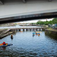
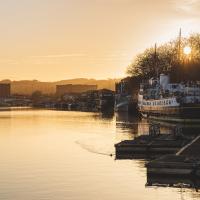
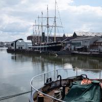
Harbourside Milestone
17 Mar 2021
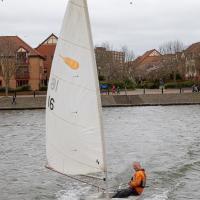
The other day I realised (hello, Maggie!) that my next walk would be my hundredth, and that I'd done 393.4km so far. I figured it would be nice to get to 100 walks and 400km on the same walk, so I went for a nice long harbourside wander after work, rather than dashing out at lunchtime. As it turned out, we're just coming up to the time of year where I can leave the house at 5:30 in the evening and there's still just enough light to take photos by the time I've made it around the harbourside. Though only just, and mostly because I've got a full-frame camera that's not bad in low light...
Still, the evening light made a lovely change, and some of the photos turned out to be pretty good photos per se, rather than just record shots of my walk. I'm looking forward to more evening walks like this as summer approaches.
On the way around this evening I wandered through one of the oldest bits of the city to extend my walk and snapped some interesting bits of architecture, including an NCP car park(!) and a nighttime shot of one of my favourite subjects, the clock tower at the Albion dockyard.
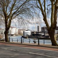
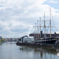
Mardyke then and Now
18 Mar 2021
Reproducing historical photos seems to be a developing interest for me. On today's wander I just went for my normal coffee at Imagine That, but along the way I stopped at Baltic Wharf (the modern housing estate; historically-speaking, I was probably in between Canada Wharf and Gefle Wharf—about here, in fact) to reproduce a 1930s photo of the Mardyke area from the Tarring collection.
Mardyke, from what I can work out, means "a ditch along the margins". Before my researches, I only really knew the name from the Mardyke pub, a big place on the Hotwell Road. Everyone knows the Mardyke, partly because of its size and signage, but I've only been in once or twice, too long ago to remember much of what it was like. However, the wharf there used to be known as Mardyke Wharf, and the area in general as Mardyke. (I just found an 1826 painting by Thomas Leeson Rowbotham of "Mardyke seen from near Hilhouse's Dock, showing the 'Clifton Ark' floating chapel" that shows the area before much development had happened, incidentally, and now I feel like I need to find out a bit more about the floating chapel...)
I enjoyed snapping the "after" photo; the process involved moving a group of swans out of the place I needed to stand to get the photo; luckily I've started carrying waterfowl food along with my on my harbourside jaunts, so I could use bribery rather than a more confrontational approach. Not sure I'd fancy my chances against a swan, though I did once team up with another passerby to shoo a recalcitrant one off the Redcliffe bascule bridge so a busful of commuters could continue their journey to work...
Via Know Your Place Bristol/the Tarring Collection.
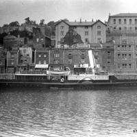
The Mardyke area—apparently Mardyke means a dyke on the margins, which would make sense for the location—in the 1930s. That's got to be a Campbell paddle steamer from their White Funnel fleet, but I don't know which one. Looks to be a similar configuration to the Princess May, though the paddles look a bit different. In the background, the Mardyke Pub still stands today, but the three largest buildings do not. They are:
Top right: the Clifton National School (there's a Loxton sketch uploaded to this Wander where you can see the name on the front.)
Directly in front and below the Clfiton National School, on the main Hotwell Road: The Clifton Industrial School, Mardyke building.
Standing halfway up the hill, more towards the middle of the picture: the Clifton Industrial School, Church Path Steps building.
Lots of info to be found on the Industrial Schools here:
In addition to their classroom lessons, the boys were employed in tailoring, shoemaking and brush-making, with basket making later added. The boys also assisted with the kitchen, laundry, and house work. In 1870, some additional rooms were rented in the locality for use as an infirmary if required. A School band was established.
I can't find so much on the National School (though apparently the Bristol Archives have some of their records) but the Clifton & Hotwells Character Appraisal suggest it was built in 1835 and, along with the Industrial School buildings, destroyed during WWII:
A bomb also largely destroyed the Clifton National School and Mardyke House School. The lack of bomb- proof shelters in Clifton led to the Clifton Rocks Railway to be used as shelter, which was prepared for occupation in 1940.
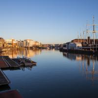
I wasn't going to take a very long walk on this nice spring evening; it just happened. I was going to knock off a path or two on Brandon Hill, home over centuries to hermits and windmills, cannons and Chartists, and then just wander home, stopping only to fill up my milk bottle at the vending machine in the Pump House car park.
However, when I heard a distant gas burner I stayed on the hill long enough to see if I could get a decent photo of both the hot air balloon drifting over with Cabot Tower in the same frame (spoiler: I couldn't. And only having the fixed-focal-length Fuji with me didn't help) and then, on the way home, bumped into my "support bubble", Sarah and Vik, and extended my walk even further do creep carefully down the slipway next to the old paddle steamer landing stage and get some photos from its furthest extreme during a very low tide...
I bumped into my friend Lisa in town during yesterday's wander, and we decided to have a wander today, too. We managed quite a long ramble, starting up through Clifton and nipping down Park Row to investigate the two tower blocks I'd noticed popping up behind Park Street yesterday, then took in a few roads I'd not managed to get to before, including cutting through the grounds of Bristol Grammar School.
Hotwells Evening
29 Mar 2021
Just a little potter around Hotwells with Sarah and Vik. I didn't visit any new streets, but I liked a couple of the photos a lot.
A London Wander in Southville
10 Apr 2021
There's a bit of Southville that I've been meaning to get to for some time, where the streets seem to take some strong inspiration from London. There's a Camden Road that crosses with an Islington Road, and a Dalston Road, even an Edgeware Road. For me these names are more evocative than the rather more exotic names I passed by to get there—Sydney Row or Hanover Place, say, because I've actually been to the places in London. The last time I was in Islington I saw Monkey Swallows the Universe play at The Angel, and I can't think of Camden without remembering a gondola trip with my friend Tara where a cheery youth played Beatles music for us on a saz...
I really liked this little area, with its mostly well-kept pretty houses and hints here and there of the creative side of the residents. It's arty and down-to-earth at the same time, and I wouldn't mind living there, I think.
On the way there I got the chance to walk through Underfall Yard for the first time in a while, and on the way back I had my first take-away hot food for many months, grabbing some crispy fried squid from the excellent Woky Ko at Wapping Wharf.
This is the first time I've been able to walk through Underfall Yard in months; it's been closed during the lockdown, and it's really reminded me how much nicer the route around the harbourside is when it's open. Cumberland Road is just dull.
Apparently the electric motor that still winches ships up out of the water on this "heave-up" slip (patented 1819 by Thomas Morton of Leith) dates from 1924, when it replaced the previous hydraulic system. I've never been there to watch a ship be hauled up, but it regularly deals with things as large as the Matthew.
The listing has this to say:
Patent slip and quay walls. Mid C19, restored 1888. Granite and Pennant rubble. 1 in 14 inclined slip with rails and timber cradle on wheels, drawn by an electric winch. Quay walls extend approx 50m along frontage of the Underfall Yard. HISTORICAL NOTE: Built on land reclaimed behind Jessop's 1809 Overfall Dam, originally part of the c1850 Nova Scotia Yard, purchased by the Docks Committee in 1880. Capable of raising a load of 250 tons. (Lord J and Southam J: The Floating Harbour: Bristol: 1983-: 65).
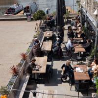
A New Wander, a New Cafe
21 Apr 2021
Obviously, I was trying to connect to the industrial history of the Canon's Marsh area, to the old gasworks, the docks railway, the warehouses they blew up to make way for all the rather soulless modern stuff (though I do like the Lloyds building, at least.) But what I mostly got out of today's walk is a new cafe to go to for my lunchtime outings. It's perhaps a little closer than both Imagine That and Hopper Coffee; not quite as close as Foliage and Twelve up in Clifton Village, but also not at the top of a steep hill.
No, not the mediocre Costa, but only a little way away from there: Rod and Ruby's, which opened in 2018 and which I've seen in passing several times but never popped into until today. What can I say? I was foolish. Great flat white, lovely interior, astoundingly good cannoli.
Sometimes you just have to get your head out of history and enjoy a pastry.
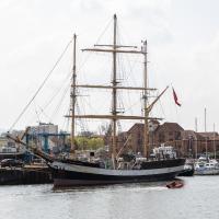
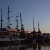
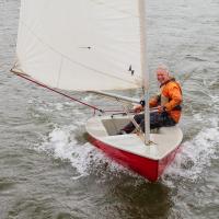
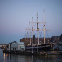
Formerly an arctic trawler, built in Le Havre1, now a sailing trainer.
1 [Great film](https://en.wikipedia.org/wiki/Le_Havre_(film)), by the way, and also an [interesting city with a real architectural heritage](https://en.wikipedia.org/wiki/Le_Havre) that I'd like to see some day...
Canons Marsh Coffee Trip
29 Apr 2021
Another quick excursion to Canon's Marsh, tempted back by Rod & Ruby's cannoli and flat white. This time I poked around some bits of the modern flats I'd not really experienced before, mused on the old gasworks, and headed back down the Hotwell Road, spotting a re-opening gallery and finishing off at the Adam & Eve, for which some locals are currently rushing to launch a bid to turn it into a community business rather than have a developer turn it into yet-more flats.
I was in a bouncy, positive mood, helped out by Life Without Buildings' Live at the Annandale Hotel album1. Note to self, though: the album is nearly an hour long, so if you hear the encore starting and you're still halfway down the Hotwell Road, you'll probably be late back from lunch...
1 That review's well worth a read. Music journalists tend to go extra-dreamy when trying to describe Sue Tompkins. See what I mean:
She circles her limber tongue-twisters, feints, and attacks from unexpected angles, dicing and rearranging them with the superhuman brio of an anime ninja and a telegraphic sense of lexical rhythm.
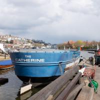
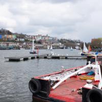
This is the stern of MV Balmoral, previously owned by P&A Campbell, the steamship operators, who I've mentioned once or twice before.
I think this has changed hands (or at least management) a few times. I've only been in there once, and they seemed to be one of those places where the staff are surprised to have found themselves in charge of a restaurant. Might be great now, though; that was years ago.
Another Day, Another 50 Metres
29 May 2021
I met my friends Sarah and Vik at Riverside Garden Centre today; I needed to buy some compost for repotting my wildly-overgrowing aloe vera, and I went a little bit out of my way to knock off a stretch of Ashton Road. It was a pleasant enough walk in the surprisingly warm (and surprising-not-tipping-it-down-on-a-Bank-Holiday-weekend) weather.