Tagged: boat
A Water-Based Wander
11 Dec 2021
I woke up on this Saturday with a headache, feeling like I'd not slept at all. As well as that, I'm still in some pain from the wisdom tooth extraction I had a few weeks ago. I moped about the flat for a while and then decided that the best thing to do was to force myself out on at least a small walk to get some fresh air and coffee.
Was there anywhere I could walk locally that I'd never been? Actually, yes! Although it's not a road, and I didn't walk it, there is actually one route that I've not travelled so far in my wanders. And it even had coffee near its far end...
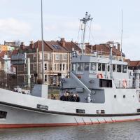
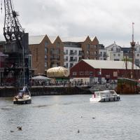
I'm heading for a coffee from Imagine That, in the Bristol Marina. Which is on the other side of harbour. Normally I'd have walked down that side to get there, but today...
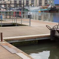
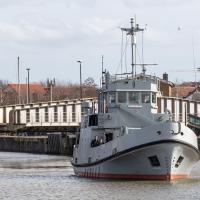
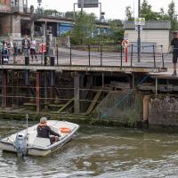
First, though, we'll take a poke around the Harbour Inlet. Here's Skyloom just pulling away from the pump-out station.
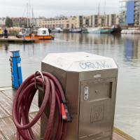
This is a LeeSan LeeStrom LS200W Pump Out Station, I believe. It pumps things out of boats. You would probably rather I drew a veil over the details.
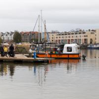
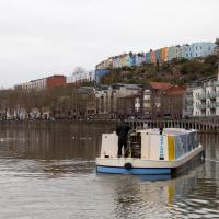
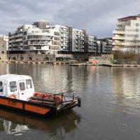
The cross-harbour ferry "ties up" to the quay at either side by dropping a hoop over a short post fitted to the edge. The hoop is lifted and dropped remotely, by a line running to the little cabin aft. The passenger ramp is also remotely operated—you can see the little block and tackle arrangement running to a pulley with another line back to the cabin.
The boat's crewed by a single person, and they're usually accurate enough with their aim and their remote controls that they don't need to leave the cabin at all during their back-and-forth trips from here, the harbour inlet, to the SS Great Britain steps on the other side. These days they've stopped taking coins, and avoid corona cooties by staying behind their cabin window and holding up a card reader to take your £1.20.
Bristol has a long tradition of ferries. The Rownham Ferry near me was operating in the 12th century, and I was reading about the planned temporary closure of Gaol Ferry Bridge this morning, which fairly obviously is the bridge that replaced the ferry that used to run between Bedminster and the New Gaol.
Interesting how "new" is quite a stretchy word. The "New" Gaol was demolished in 1898, and of course the bridge spans the "New" Cut, the diverted section of river that was completed in 1809...
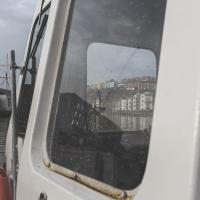
There's something I've always loved about shooting through rainy ferry windows. I used to do it all the time on the commuter boats.
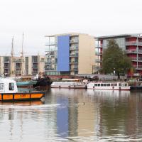
So, that was my first (and probably only) wander that involved a boat. I suppose there's a chance I could get out on a round-the-harbour trip with my old friends, the Bristol Ferry Boat Company, but I don't know what their schedule is like in these Covid-stricken times. I imagine the Omicron variant won't help, either...
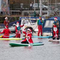
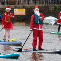
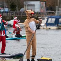
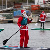
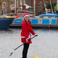
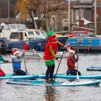
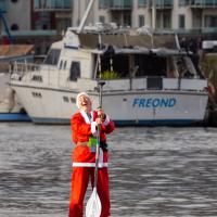
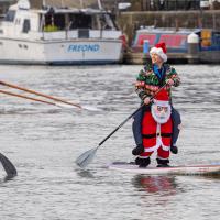
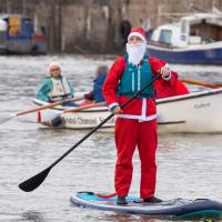
My friend Lisa texted me to see if I wanted to pop down and take a photo or two of the event she was taking part in: Santa SUP. SUP Bristol organise stand-up paddleboarding on the floating harbour, and their annual Santas-on-paddlboards event is quite the sight.
On the way there, I grabbed a historical photo I'd been wanting to recreate for a while of the shiny and new Cumberland Basin flyovers back in 1965, because I reckoned I could fit finding the same viewpoint into my outbound journey. Also, after having only used it on a wander for the very first time yesterday, I managed two crossings in the cross-harbour ferry today to get to the best locations for snapping the paddleboarders...
So, then, this wander is mostly a bunch of photos of paddleboarding Santas. Tis the season... Enjoy!
A Random New Year's Day Wander
01 Jan 2022
I picked a fairly arbitrary reason for a wander today. Really, I just wanted to do a New Year's Day wander just to get out of the house and to set a precedent for the year to come.
My ostensible reason was to investigate what looked like a road on my map that quartered the lawn in front of the Ashton Court mansion. As it turned out, this is just a muddy footpath/desire line similar to a half-dozen other tracks nearby, and must be some kind of bug or misclassification with the mapping system I'm using, but that's not important. What's important is that I went for a little walk on the first day of the year. As a bonus, I did happen to wander down a couple of sections of new footpath, so technically I broke some new ground too, which is nice.
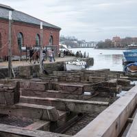
We'll leave today's wander with a snap of the Patent Slip. I wonder if the newer timber closest to the camera is the greenheart that they're renewing some of the structure with? Hardy stuff, as Wikipedia says:
The wood is extremely hard and strong, so hard that it cannot be worked with standard tools. It is durable in marine conditions, so it is used to build docks and other structures... The Fram and the Endurance, made famous in the polar expeditions of Amundsen and Shackleton, were the two strongest wooden ships ever constructed and were sheathed in greenheart to prevent them from being crushed by ice.
Lunchtime Reproduction (of an old photo...)
17 Jan 2022
This was basically the quick lunchtime jaunt I tried to do at the beginning of January, only this time I actually managed to get to roughly the viewpoint I'd been hoping for to recreate a historical photo of the Bristol International Exhibition.
I did this walk about a month ago, but I've been a bit poorly and not really up to doing much in my spare time, and it's taken me this long to even face processing even these few photos. Hopefully normal service will be resumed at some point and I can carry on trying to walk any roads and paths that I need to do to make this project feel complete...
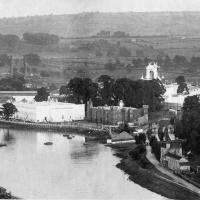
From Bristol's Lost City, by Clive Burlton, available from Bristol Books; photograph from the author's own collection.
(And extra credit goes to my parents for buying me the book for my birthday! Thanks!)
The Bristol International Exhibition site, presumably around 1914 or not long after. You can see the Rownham Ferry in use, too. I still find it pretty amazing that there used to be a busy ferry and a significant railway station on this little scrap of land that I just used to know as the grassy bit at the start of the towpath, let alone a replica of Bristol Castle!
Lunchtime Cliftonwood Wander
18 Jan 2022
Another workday, another quick lunchtime trip to get me out of the house. This time my flimsy pretext is a tiny bit of Clifton Vale Close that I'd apparently not walked, and the fact that although I'd walked down Church Lane at least once before I still hadn't taken a single photo of it. Really I just fancied a mosey through Cliftonwood in the sunshine, with the promise of a coffee from Clifton Village at the top of the hill.
Bedminster Trip for New Walking Shoes
26 Feb 2022
I needed to buy new walking shoes—my old ones were squeaking and it was driving me up the wall—so I ordered some for collection from Taunton Leisure on East Street in Bedminster, and decided to make picking them up an official wander.
I didn't cover any new ground within my mile, but I did take advantage of the trip to take in a few interesting things just outside my normal radius, mostly New Gaol-related. Along the way there are a couple of sanitation-related diversions, including a visit to a rare manhole cover. You can hardly wait, I can tell!
Anyway, on to happier contemplations. Here we see the Merchant's Road bridge (Junction Bridge, to give it its official title) swinging closed behind the Pride of Bristol.
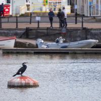
I took a long lens with me today in case the cormorants were around; I've been meaning to try taking a better snap of them for a while. Here's one on a buoy that seems to have "hosting cormorants" as its only purpose. There's often one there, anyway.
A Swing of the Plimsoll Bridge
24 Apr 2022
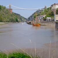
I was originally going to head over to the Ashton area to see if I'd missed any bits around the football stadium—and also to grab some lunch from the Tobacco Factory Market—but in the end I got a little distracted by having accidentally chosen exactly the right time to see the Plimsoll Bridge swing on one of the first busy days of Spring, where a lot of pleasure trips tend to head out down the Avon (and possibly the New Cut) from Hotwells.
In the end I mostly snapped that, and just a couple of photos from the Ashton area where I grabbed some lunch but didn't do any new exploring.
The Plimsoll Bridge is definitely not the oldest swinger in town. In fact, it may be the youngest swinger in town. I think the only other functioning swing bridges on the floating harbour (side-to-side rather than up-down like Redcliffe Bascule) are Junction Bridge (hidden in this picture, it's on the far side of the Cumberland Basin, carrying Merchants Road) and Prince Street Bridge, built in 1925 and 1879 respectively. The Plimsoll Bridge is mid-1960s.
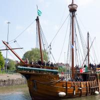
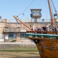
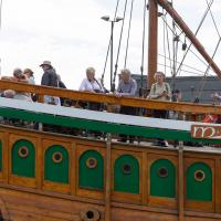
The brutalist bridge abutment is the old bit, of course, as it's mid-1960s. The boat that looks like John Cabot's 15th century caravel is the new bit. This replica was made in the 1990s, and replicated the original's 1497 trip to Newfoundland in 1997, arriving in June at Bonavista, to be greeted by Queen Elizabeth.
She's just had her annual inspection in the Albion dry dock, so I suppose this is one of her first gorge trips of the summer season.
I've been pretty awful at reading so far this year, apparently averaging about one book per month. That's a far cry from 2019, say, where I got through 41 books in the year. Today's wander was prompted by my rubbish reading, as I needed to go hand back some books to the library, because I'd managed to renew them so many times that I hit the limit on renewals. Oops. Several of them were still unread.
So, off to the Central Library for me, tail between my legs. On the way there I did my best to recreate a historical photo of Dowry Square; while I was in the area I walked under the adjacent Norman arch and poked around behind the Cathedral, and I also had a little diversion to the city centre and came back along the south side of the river, hitting some trouble with the lock gates as I finally crossed the harbour back towards home.
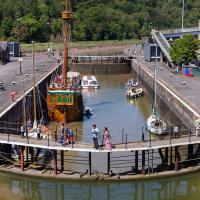
Library business concluded, I decided that my feet weren't quite sore enough, so decided to head back home by completing a circuit of the harbour rathter than just heading back down the noisy Hotwell Road. Wandering past the Arnolfini, I spotted this from a viewpoint not far from where the status of John Cabot stands, surveying the docks.
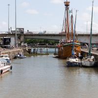
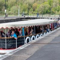
As you can see, there were quite a lot of boats waiting to leave Bristol for a jaunt down the river, most notably the Matthew, and Bristol Packet's Bagheera.
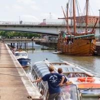
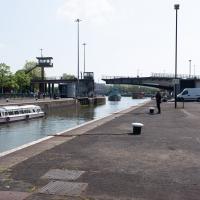
As a pedestrian I have a few alternative routes to cross. I decided to stroll down to the outer lock gate and get back to my side of the harbour there rather than going the long way around over the Plimsoll Bridge.
In the distance you can see a lockkeeper fishing in the water with a grappling hook on the end of some blue line to see if he can figure out what the gate is fouling on.
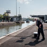
While I was tempted to hang around to see if they eventually pulled anything out of the way, the heat of the day was beating down pretty hard by this point and I didn't want to risk sunburn, so I headed home. As did all the boats in the lock, who returned back into Cumberland Basin and presumably eventually back to the city, refunding/rebooking their passengers.
I found out that my decision to leave had been a good one two days later, on Tuesday evening, when I happened to be on my walking commute home during another locking out, this time with the lock gates working. I asked the lock keeper about the problem, and apparently they'd tried hooking out whatever was fouling the gate for quite some time on Sunday, but eventually gave up and sent divers in on Monday, who pulled out a large section of chain-link fence that was fouling the south lock gate and got everything working again.
I'm in the habit of going over to the Tobacco Factory Market on a Sunday. I think I've walked all the routes around that way, but as a Plimsoll Bridge swing let me cross the road to the far side of Brunel Way on my return journey and I took a couple of photos of the brownfield development at the old Ashton Gate Depot site I thought I'd call it a Wander and pop some photos up.