Tagged: electricity
Leftovers with Lisa
01 May 2021
I didn't get to all the little leftover streets around the northeastern part of my area in today's wander, but I definitely knocked a few off the list, plus Lisa and I enjoyed the walk, and didn't get rained on too badly. We spotted the hotting-up of Wisteria season, checked out Birdcage Walk (both old and new), ventured onto the wrong side of the tracks1 and generally enjoyed the architecture.
1 Well, technically we probably shouldn't have been on the grounds of those retirement flats, but nobody started chasing us around the garden with a Zimmer frame
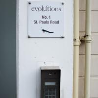
Apparently they're a London-based multimedia production house and this is their first "regional facility". Which presumably explains why they're just over the road from the BBC; I imagine they want to provide outsourcing to Auntie.
Sequel Injection
07 May 2021
I saw this tweet the other day and started thinking of my second Covid-19 vaccination as my "Sequel Injection" (to a geek, it's funny. You'll have to take my word for it.) Whatever you call it, this morning I went and got it.
It was in the same place I got my initial injection—my left arm! No, okay, it was at the Clifton College Prep School. I didn't take any photos of the event itself; the NHS production line is so efficient you barely have time to do anything else, even if the privacy of other patients wasn't a factor.
Along the way I mused at all the road resurfacing going on in Clifton, and also discovered a secret (okay, not-well-known and possibly slightly trespassey) way into Canynge Square, and on the way back I knocked off a few streets from my "leftovers list" of north-east Clifton. I've got much of Clifton done now, with the only obvious "to dos" on the east side of Whiteladies Road...
It was quite a long walk, and I'm feeling pretty tired now, though that might be the effects of the jab too, I suppose. Anyway. Tomorrow and Monday I'm walking outside Bristol, I think, and I imagine my feet will need some recovery time on Sunday, so it might be a while before I post another Wander.
Bank Holiday Street Art
31 May 2021
A nice warm Bank Holiday Monday saw me walk back over to Bedminster to do justice to something we glimpsed on my last wander. Along the way I spotted a couple of new pieces of street art tucked away on the south side of the Cumberland Basin Flyover system, so this turned into a micro-graffiti walk.
It used to be an Auction Rooms, for both Dreweatts and BCVA, from what I recall. I went to my very first auction there, in fact, back when I had a year of "Artist Dates" in 2013.
I should start doing those again, now we're (hopefully) going to be able to go places more freely again.
A Trip to the Library
08 Jun 2021
I had to return a book to the library—Ellic Howe's Magicians of the Golden Dawn, very interesting, thanks for asking—so I decided to pick the Central Library as my drop-off point and walk down a segment of Deanery Road that I've surprisingly overlooked so far. In any normal time I'd have been walking to work that way quite often, or heading through at the weekend on the way to do some shopping in the city centre, or for a coffee at St Nick's, but those excursions have been quite thin on the ground for the last year or so, for obvious reasons.
I've never been inside a single building on Deanery Road itself; the Library is technically on College Green and the rest is mostly student accommodation or Bristol College buildings, by the looks of things. It's a fairly mediocre street, used merely to get to other places. (St George's Road, which merges into it, at least has the distinction of several good shops verging from the practical and long-lived car radio fitters to the excellent little Dreadnought Books, sadly currently closed for refurbishment...)
After dropping off my book I came home via the harbourside, the better to enjoy the nice sunny blue skies of the day.
Library, Bookshop, Coffee
03 Jul 2021
I was headed into town to return RA Gilbert's biography of AE Waite to the library and along the way I noticed that Dreadnought had finished their refurbishment, but wouldn't be open until midday. That left me some time to kill, so I bimbled around the old St Augustine's/Gaunt's area for a while, then headed up Park Street for a coffee and a snack to eat on Brandon Hill before heading home the way I'd came so I could pop in and buy a pamphlet on the Hot Well I'd been interested in for a while.
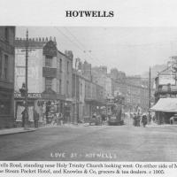
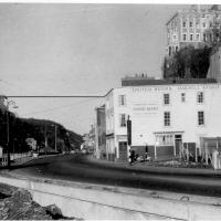
Circa 1905. See the previous photo for the modern-day version. Several of the houses on display were destroyed during the blitz of 24 November, 1940.
I'd never heard of this being called Love Street before. It does seem that it was, though: I just searched through all the various digital research materials I've gathered during this project and found this tidbit in A Bristol Miscellany:
It is proposed to drain the whole of this district by means of a low level sewer commencing at the bottom of Woodwelllane or Jacobs Wells road nearly opposite Woodwell crescent passing along the whole length of the Hotwell road and Love street to Dowry square continuing along in front of Dowry Parade and the Gloster Hotel passing the bottom of Granby Hill in front of Ashton place to Saint Vincent's Parade at which point it will receive the sewage from the Royal York Crescent, the West Mall and Caledonia Place, from which point it will continue along in front of Hotwell House underneath the rocks to the towing path in front of Point House at the Round Point to the present outlet of the High Level Sewer District being about 1,100 yards below the Hotwell House.
...but no other mentions than that one. Looking around the web, I can see a few more references, including this delightful business card for Hotwells gardener John Waldron.
I did idly wonder if "Love Street" might've been a euphemism for something, at some point? There were an awful lot of sailors coming off boats nearby! But perhaps it was simply a nice name for a nice stretch of road...
Photo from Hotwells and the City Docks, ISBN 9781899388288
Autonomous Vehicle
14 Jul 2021
As it turned out, I didn't manage to get a coffee on my lunchtime coffee trip, as Imagine That were briefly shut down by a Covid-19 exposure notification (false alarm, it seems.) On the plus side, my trip was made worthwhile by spotting a couple of people from the University of Bath Mechanical Engineering Department testing an autonomous body-finding catamaran, which isn't a phrase I was ever expecting to write...
A Journey to the Far East
25 Jul 2021
The far east of the intersection of my one-mile radius and Bedminster, anyway. I was feeling a bit tired this morning, so I motivated myself to get out of the door by imagining one of Mokoko's almond croissants. That got me on my way, and I wandered across to Bedminster, through Greville Smyth Park, along most of the length of North Street (looking out for new Upfest 75-pieces-in-75-days artwork as I went) and then onto some new roads at the far end.
I only wanted to knock a few streets off my "to do" list, but by the time I'd diverted here and there to check out various bits of graffiti and other attractions and come back via the aforementioned purveyors of Bristol's finest croissants, I'd walked 7.4km. Not bad for someone who woke up tired, and at least I've done something with my day. I'm very glad the weather broke (we had tremendous thunderstorms yesterday), even if some of the pictures might've looked better with a blue sky. I was getting fed up with walking around in 29°C heat...
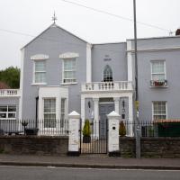
It has many good reviews on Tripadvisor. Certainly looks well-kept. This area, especially Coronation Road, is quite well-known for its reasonably-priced bed-and-breakfasts.
Fresh Fields
17 Oct 2021
For the first time in a while, I had the time and energy to go further afield and knock off some new roads from my "to do" list. I headed through the first Hotwells Festival to Ashton and Bedminster to cross off a few of the suburban roads south of North Street.
First, though, I decided to try to reproduce an old photo of the now-demolished Rownham Hotel just around the corner from where I live...
Here's the view I wanted to take a stab at reproducing. Bristol's Lost Pubs—a great website, which sadly currently seems to be lost itself—said:
Originally known as the Hotwells Tavern. Around 1873 when the entrance to Cumberland Basin was enlarged, a pub named the Rownham Tavern was demolished and Rownham ferry moved downstream towards the Hotwells Tavern, not long afterwards the name was changed to the Rownham Hotel. The pub was removed in 1969 for road Widening.
This particular image is from Brewerypedia; I'm afraid I don't know its original provenance.
A Water-Based Wander
11 Dec 2021
I woke up on this Saturday with a headache, feeling like I'd not slept at all. As well as that, I'm still in some pain from the wisdom tooth extraction I had a few weeks ago. I moped about the flat for a while and then decided that the best thing to do was to force myself out on at least a small walk to get some fresh air and coffee.
Was there anywhere I could walk locally that I'd never been? Actually, yes! Although it's not a road, and I didn't walk it, there is actually one route that I've not travelled so far in my wanders. And it even had coffee near its far end...
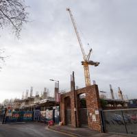
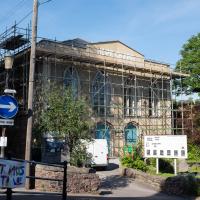
As recently as September this building site was just a big flat block of mud.
This was McArthur's warehouse; it will become McArthur's Yard
Built in the 19th century as a malt house, the McArthur’s Yard site includes several warehouse buildings and structures which have been empty for 20 years. Originally the headquarters of Bristol-based metal merchant McArthur’s Group, the site is in a prominent position surrounding Bristol’s floating harbour, adjacent to the SS Great Britain.
I was just about starting to feel better—the antibiotics seemed to have kicked in for my dental issues, and it had been some days since I'd left the house, and I was at last starting to get itchy feet. So, a wander. But where? Well, there were a few industrial bits near Winterstoke Road in the Ashton/Ashton Vale areas of Bristol that needed walking. I knew they were likely to be quite, well, unattractive, frankly. So why not do them while I wasn't feeling exactly 100% myself? Maybe it would fit my mood. Hopefully you're also in the mood for a bit of post-industrial wasteland, for that's what some of this feels like...
Then, at the last minute, I thought again about the Bristol International Exhibition—I've got a book about it on the way now—and that gave me another goal, which could just about be said to be in the same direction, and I decided to walk significantly further than my normal 1-mile limit and try recreating another historical photo...
Sadly I don't know much about the Ashton area; it's just on the edges of my mile and I rarely have cause to go there. It's brimming with history, I'm sure: the whole South Bristol area rapidly developed from farmland to coal mines to factories to its current interesting mixture of suburbs and industrial work over the last few hundred years. As a more working class area less attention was paid to it by historians, at least historically-speaking, than the Georgian heights of Clifton, and much of it has been knocked down and reinvented rather than listed and preserved. I see here and there some of this lack is being addressed, but I'm afraid I'll be very light on the history myself on this wander, as most of my usual sources aren't throwing up their normal reams of information as when I point them at Clifton, Hotwells or the old city.
This may be somewhere around my actual destination today, though perhaps a little too much toward the east.
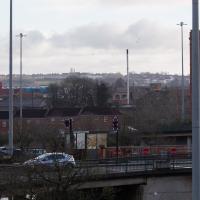
The buildings and green space on the hill in the background are the Knowle West Health Park. I'm pleased to have figured this out by using an OS map and a ruler and projecting a line from where I'm standing through the Tobacco Factory flag that you can just see poking up from Bedminster (you can see it on the corner of the building in this earlier pic](https://omm.gothick.org.uk/image/7175), then looking for densely-packed contour lines further out of town. Very old-school, but it worked!
I'm probably heading in more of a Bedminster Down direction. It's a similarly elevated green space further west, which is hidden behind the bond warehouse on the right in this pic.
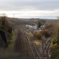
Well out of my one-mile radius now, here's a view from the railway bridge at Bedminster Down Road, looking back to the east.
This is Parson Street Junction, originally called Portishead Junction, where the Bristol to Exeter line, straight on, branches off into the Portishead Railway line, curving away there on the right. Parson Street Station in Bedminster is directly behind us on the other side of the bridge.
Phase One of MetroWest should see the currently-frieght-only Portishead line re-open to passenger traffic, though I wouldn't hold your breath. It seems "Metro-" is an old Roman prefix meaning "multiply all your time and budget estimates by ten".
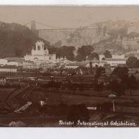
Source: Bristol Archives, Vaughan Collection.
Here we look, apparently from Bedminster Down, towards the "white city", the Bristol International Exhibition buildings of 1914.
This is the photo I've trooped all this way to reproduce. Have I managed to find the right spot?