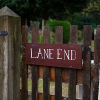
Tagged: lane
Fresh Fields
17 Oct 2021
For the first time in a while, I had the time and energy to go further afield and knock off some new roads from my "to do" list. I headed through the first Hotwells Festival to Ashton and Bedminster to cross off a few of the suburban roads south of North Street.
First, though, I decided to try to reproduce an old photo of the now-demolished Rownham Hotel just around the corner from where I live...
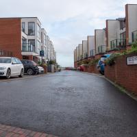
I went out simply wanting to knock off the very last little unwalked section of Clanage Road, over by Bower Ashton, which has been annoying me for a while as it's quite close by and I've walked the other bits of it several times. So, my plan was to nip over to Greville Smyth Park via a slightly unusual route to wander Clanage Road and tick it off.
Along the way, though, I inevitably got a bit distracted. I took a few photos of Stork House, a grand Hotwell Road building that's recently been done up a bit (I imagine it's student lets, though I'm not sure) and which I found a reference to in a book about the Port Railway and Pier the other week, and also tried to match up a historical photo of Hotwells before the Cumberland Basin Flyover System laid it waste, which included some interesting markers I'll have to do a bit more digging into...
I was just about starting to feel better—the antibiotics seemed to have kicked in for my dental issues, and it had been some days since I'd left the house, and I was at last starting to get itchy feet. So, a wander. But where? Well, there were a few industrial bits near Winterstoke Road in the Ashton/Ashton Vale areas of Bristol that needed walking. I knew they were likely to be quite, well, unattractive, frankly. So why not do them while I wasn't feeling exactly 100% myself? Maybe it would fit my mood. Hopefully you're also in the mood for a bit of post-industrial wasteland, for that's what some of this feels like...
Then, at the last minute, I thought again about the Bristol International Exhibition—I've got a book about it on the way now—and that gave me another goal, which could just about be said to be in the same direction, and I decided to walk significantly further than my normal 1-mile limit and try recreating another historical photo...
Sadly I don't know much about the Ashton area; it's just on the edges of my mile and I rarely have cause to go there. It's brimming with history, I'm sure: the whole South Bristol area rapidly developed from farmland to coal mines to factories to its current interesting mixture of suburbs and industrial work over the last few hundred years. As a more working class area less attention was paid to it by historians, at least historically-speaking, than the Georgian heights of Clifton, and much of it has been knocked down and reinvented rather than listed and preserved. I see here and there some of this lack is being addressed, but I'm afraid I'll be very light on the history myself on this wander, as most of my usual sources aren't throwing up their normal reams of information as when I point them at Clifton, Hotwells or the old city.
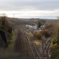
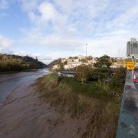
Well out of my one-mile radius now, here's a view from the railway bridge at Bedminster Down Road, looking back to the east.
This is Parson Street Junction, originally called Portishead Junction, where the Bristol to Exeter line, straight on, branches off into the Portishead Railway line, curving away there on the right. Parson Street Station in Bedminster is directly behind us on the other side of the bridge.
Phase One of MetroWest should see the currently-frieght-only Portishead line re-open to passenger traffic, though I wouldn't hold your breath. It seems "Metro-" is an old Roman prefix meaning "multiply all your time and budget estimates by ten".
More Cliftonwood
05 Dec 2020
Back to Cliftonwood for a wander that included some of the belle views of Bellevue Crescent and other bits of the easternmost part. Highlights included watching someone bump-starting an elderly Nissan Micra in the narrow confines of Bellevue Crescent.
I got interested in Bristol's medieval water supplies after poking around near Jacobs Wells Road and Brandon Hill. It was during that research I found out about a pipe that's still there today, and, as far as I know, still actually functioning, that was originally commissioned by Carmelite monks in the 13th century. They wanted a supply of spring water from Brandon Hill to their priory on the site of what's now the Bristol Beacon—Colston Hall, as-was. It was created around 1267, and later, in 1376, extended generously with an extra "feather" pipe to St John's On The Wall, giving the pipework its modern name of "St John's Conduit".
St John's on the Wall is still there, guarding the remaining city gate at the end of Broad Street, and the outlet tap area was recently refurbished. It doesn't run continuously now, like it did when I first moved to Bristol and worked at the end of Broad Street, in the Everard Building, but I believe the pipe still functions. One day I'd like to see that tap running...
There are a few links on the web about the pipe, but by far the best thing to do is to watch this short and fascinating 1970s TV documentary called The Hidden Source, which has some footage of the actual pipe and also lots of fantastic general footage of Bristol in the seventies.
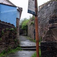
On my walk today I was actually just going to the building society in town, but I decided to trace some of the route of the Carmelite pipe, including visiting streets it runs under, like Park Street, Christmas Street, and, of course, Pipe Lane. I also went a bit out of my way to check out St James' Priory, the oldest building in Bristol, seeing as it was just around the corner from the building society.
There are far too many pictures from this walk, and my feet are now quite sore, because it was a long one. But I enjoyed it.
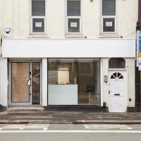
Looks like something's getting spruced up ready for opening. Good. This bit of the Hotwell Road needs some nice new shops, of any and all varieties.
This place was joined up with the shop to the left as a hot tub sales showroom, and before that it was the View art gallery. Before that it was a brothel for a while, oddly, but I think the general community reaction was a bit too hostile for it to survive. Looks like it's now been separated from the next door shop.
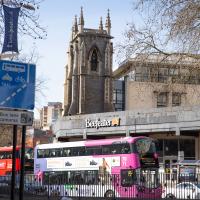
The Beefeater stands in front of the remains of St James' Presbyterian Church, but they both hide something rather older...
Little Clifton Village Details
09 Nov 2020
I like The Paragon as a terrace, especially the bowed porches. On the other side of the road, a house attic has a stone lion surrounded by rocaille leaves, according to its listing.
I also love the detail of the arrows in the wrought iron of The Mall's balconies. Today I discovered Westfield place, a road I'd never encountered that runs up to the rear of the Coronation Tap. (It's a famous local cider pub, but I've only been in a couple of times. I'm more of a beer man.)
Outside the Zone
01 Nov 2020
This started as a little local walk with my friend Lisa, but when we randomly met my friends Sarah and Vik at Ashton Court, turned into joining them for a very long wander out to Abbots Leigh Pool. Most of this was well outside my one-mile radius but it was a lovely walk.
Avoiding the Accounts
26 Nov 2020
I took the day off my day job to do my accounts—or at least do enough bookkeeping to send them to my accountant. I hate doing the books. I woke up late, tired and with a headache and decided to bunk off for a walk around Cliftonwood, Clifton Village and Clifton instead, taking in a couple of good coffees along the way. Thanks, Foliage Café, and Twelve for the flat whites.
The Long Lunchtime at the End of the World
27 Nov 2020
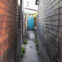
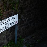
I took an extra-long break at lunchtime today as I'd taken the day off my normal day-job to do the accounts for my previous side-job, which is still generating paperwork, though not much in the way of money. This took me through some undiscovered bits of Cliftonwood, including Worlds End Lane, which unexpectedly leads to White Hart Steps. That's certainly not where I expected the end of the world to lead to...
A long ramble, starting with trying to find the Hot Well of Hotwells and leading up the side of the Avon Gorge to the Downs and then through Clifton for coffee.
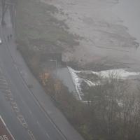
In full flow. The flat top of the water to the left of the overflowing rim sits above a semicircular-profile concrete trough that's designed to calm the water and channel it into the fairly calm wide flow you see here to reduce the erosion it would otherwise cause.