Tagged: woodland
My historical research took a wander underground recently, partly inspired by the Canynge Square sinkhole, partly by St Vincent's (Ghyston's) cave and its tunnel to the Observatory, and I was surprised to find that there might be an intact tunnel from the Bristol Port Railway and Pier still just sitting there under Bridge Valley Road. A quick search turned up this recent video by an intrepid explorer, so it's definitely still there.
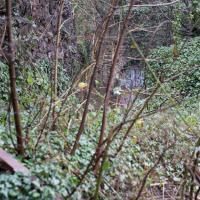
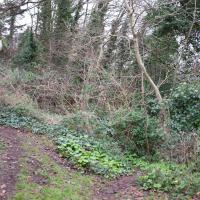
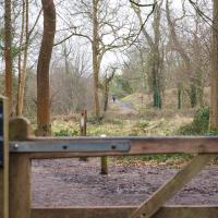
I went looking for the entrances today, and definitely found the south entrance, at the start of the Bridge Valley Path, the footpath that starts with steps at the bottom of Bridge Valley Road. It's easy to miss if you're not looking for it. I think I've figured out where the north entrance is, too, but it was getting dark at that stage and the Portway was still busy enough that crossing the road was still the normal nuisance, so I thought I'd leave further explorations for another day.
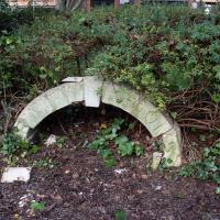
Peeking down over the edge of the start of the Bridge Valley Path you can just make out the entrance to the Portnalls railway tunnel under Bridge Valley Road. It opened in 1865 and ran to Avonmouth from a terminus in Hotwells, but was closed to enable the construction of the Portway in 1922 (source: Peaceful Portway "Memorable Walks" leaflet)
A Promenade on New Year's Day
01 Jan 2021
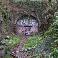
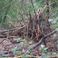
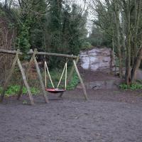
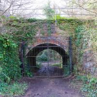
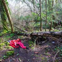
I wandered along the gorge today and found the entrance to the disused Portnalls Number 1 railway tunnel of the Bristol Port Railway and Pier. The door was unlocked, but as soon as I opened it I felt a sense of current habitation and decided discretion was the best option. There's a lot of people homeless in Bristol at the moment, and they don't need disturbing. For the same reason, I've omitted posting some pictures of a little encampment somewhat off the beaten track of the new Zig Zag, where I reversed direction as soon as I realised I'd come across a current habitation of some sort.
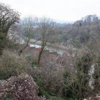
Up in Clifton it took me a little while to work out that the picture of the Promenade I was trying to reproduce was taken from the viewpoint I'd thought, it was just that the Alderman's fountain was moved from the top of Bridge Valley Road to the other side of the promenade in 1987, so trying to use it as my initial landmark wasn't very helpful!
Finally I swung past the Society of Merchant Venturers, who presumably still own most of Clifton, having bought the entire manor, including Clifton Down, in 1676, and I imagine aren't in much danger of running out of money. That's true to their motto: indocilis pauperiem pati is apparently from the Odes of Horace, and translates as "will not learn to endure poverty"...
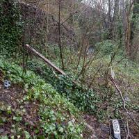
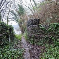
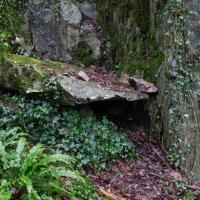
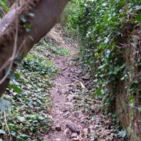
The steps still do the job. The handrail, however, is only tenuously attached to anything at the top end.
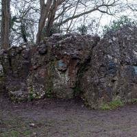
This is what I'd been looking for. An accessible entrance to the Portnalls Number One tunnel.
I examined the rocks that had been disturbed, hoping for a geode, but no joy. It's one of my dreams to randomly encounter a geode replete with Bristol diamonds, and this would actually be a not unreasonable area to find one.
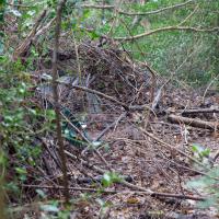
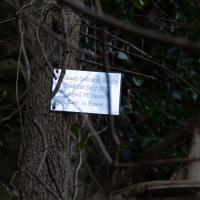
This was a little more extensive than my photos make it appear. It looked like an abandoned set of shelters made by the local homeless, but I didn't want to investigate further in case I disturbed someone.
Prince's Lane
06 Jan 2021
The International Grotto Directory website says:
Prince’s Lane might have been one of the original ancient tracks from Hotwells to Clifton, in the Avon Gorge. The site later formed part of Rownham Woods which comprised some thirteen acres. By the end of the 18th century and the early 19th century, the Society of Merchant Venturers granted to Samuel Powell a building lease, for The Colonnade (1786), St. Vincent’s Parade (1790), Prince’s Buildings (1796), and Rock House. Rock House is generally considered to be the oldest surviving building associated with the Hotwell (see Chapter 20). John Power conveyed part of the woods to William Watts for the construction of Windsor Terrace (1790-1808).
The above development of the Avon Gorge cleared Rownham Woods, and created a triangle of land on the north side of the gorge, that became enclosed as a result, by Mansion Houses, whose garden walls all entered on to Prince’s Lane. The Lane started at the bottom of the gorge, at the base rock of Windsor Terrace, and came out half way up Sion Hill. It is clearly shown as a public footpath, dotted with trees, in Ashmead’s map of 1828. Some of the gardens were quite steep in parts and therefore, had to be terraced, because of the gradient of the gorge.
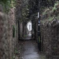
I've passed Prince's Lane literally thousands of times in my life, every time I've walked past the Avon Gorge Hotel, which itself started (in 1898) as the Grand Clifton Spa and Hydropathic Institution and pumped water up from the Hot Well for its hydropathic treatments. I've never actually ventured down it until today, or at least nothing like as far down it as I did this afternoon—I may have poked my head around the back of the hotel to see the original pump rooms at some point in the past.
This was a great wander, though it does very much feel like a private road, and frankly I may have been pushing my luck a bit by winding my way between the astoundingly big back gardens of the houses of some presumably very wealthy Cliftonites, but I felt vaguely justified in exploring the history of one of the oldest footpaths in my part of Bristol...
It's at about this point that you realise you're on a narrow path between two sets of enormous, long back gardens, those of Prince's Buildings up the hill, and those of St. Vincent's Parade below.
Morning Walk
08 Jan 2021
Tempted by a hopeful repeat of yesterday's weather, I got up early this morning and went for a short walk up into Clifton Village, around Observatory Hill, back down the Zig Zag and home. Instead of beautiful and mysterious fog and crisp freezing brightness I got some murk and slight dampness which included witnessing a road-raging van driver and finding that it still wasn't cold enough for the hot well to be even gently steaming when I got down there. I've still never seen it steaming, but I've been told it does, on colder days.
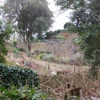
...and another rock slide in the background. Also, just on the left in the wall at the back there may be a bricked-up opening; a geological field trip guide I found says:
In the back wall is a bricked-up adit, presumably representing the entrance to a former iron ore or lead mine.
I may have to go back and take another snap of that.
Snowy Leigh Wander
24 Jan 2021
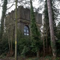
I started this wander with my "support bubble" Sarah and Vik, after Sarah texted me to say "SNOW!" We parted ways on the towpath and I headed up into the bit of Leigh Woods that's not actually the woods—the village-like part in between Leigh Woods and Ashton Court, where I'd noticed on a map a church I'd not seen before. I found St Mary the Virgin and quite a few other things I'd never experienced, despite having walked nearby them many, many times over many years, including a castellated Victorian water tower that's been turned into a house...
Unexpected Snow
31 Jan 2021
I just nipped out to post a blood test (not Covid-related) and check that my car was okay, because I've not driven it for weeks. I was just going to walk up to Clifton Village, but I spotted the opportunity to re-park the car on my street rather than up the hill around the corner where it was, so instead I got in, intending just to move a hundred metres, but it turned over slowly before it started, and then warned me that the battery was very low and I should go for a long drive to recharge it.
So, I did my best, zipping up the A4018 to the motorway junction and back again, dropping off my blood at a postbox along the way, and while I did that, it started snowing. I noticed it was low tide, too, so when I got back home I headed back out again, this time on foot and with a camera so I could see if I could find any evidence of the Hot Well steaming.
I saw not a single sign of the Hot Well steaming, but it was quite a nice quick outing and I enjoyed my brief walk in the snow. Iike Hinton Lane, too, and while it's all old ground I was re-treading, I did at least get a picture or two with a bit of snow and some of the cold winter atmosphere of the trip, I think.
In Between
06 Feb 2021
A lovely walk in the early spring sunshine with my friend Lisa. We headed directly for Jacobs Wells Road, to start off around the scene of one of our earlier walks, but this time took in Jacobs Wells from QEH upward, stopping to snap some photos of a Bear With Me, some interesting areas between Park Street and Brandon Hill including a peculiarly quiet enclave with a ruined old build I'd never found before, then crossed the Centre to grab take-away pies from Pieminister (I had the Heidi Pie) and head back to my place down the harbourside.
It's basically in the back yard of the Trinity Rooms, which is a house on Hotwell Road that I believe once connected in some way with Holy Trinity Church. My guess would be that that is some bit of leftover architecture from some demolition or change or other and someone's taken it upon themselves to keep it there as a bit of local history. Interesting!
Leigh Woods Walk
14 Mar 2021
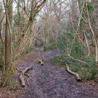
An enormous walk today, or at least it felt enormous. My feet are sore, anyway. I started off recreating a couple of local historical photos in Hotwells, but then headed for my traditional walk along the towpath in the Avon Gorge to the far extreme of Leigh Woods, up and through the woods to the height of the Suspension Bridge, finally crossing into Clifton Village for a well-deserved vanilla latte.
I say "traditional" because this used to be a very regular route for me, first walking, years and years ago, and later jogging—this route combined with a circuit of the Downs on the other side used to be my way of making sure I was fit to do a half-marathon (I did six of them in total, between 2010 and 2014).
I miss the routine of this walk, even though it's a long way and it used to pretty much wipe me out when I did it—I'd come back home and collapse and do very little for the rest of the day. But perhaps that's what Sundays are for, and I should try to remember that.
Doing this walk regularly was quite a meditative experience. Not so much of that today, but once I got to the further extreme of the towpath, where the roar of the Portway traffic on the other side of the river dwindles and I turned into Leigh Woods to climb ever closer to birdsong and further from rushing cars, I did seem to recapture a little of the feeling of previous walks. (I would say my mind cleared, but I was mentally singing along to Life Without Buildings' The Leanover for most of the wander. There are worse songs to have stuck in one's head, though; it's a great track...)
Anyway. Apparently the walk made me more likely to ramble in words, too. I'll stop now :)
This used to be nigh-impenetrable forest. I saw a deer here once, probably the only time I've seen a wild deer in Bristol, though I understand they're quite common.
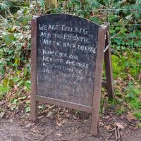
More details here
Ash dieback is caused by a fungus that originated in Asia. It doesn’t affect ash trees native to the region, but has had a devastating effect on European ash, which is found in the UK.
The fungus produces small fruiting bodies between July and October. The spores can blow many miles away, which is what makes it so difficult to control. Once it’s landed, the fungus grows inside the tree and blocks its water systems, causing the tree to die.
I wasn't going to take a very long walk on this nice spring evening; it just happened. I was going to knock off a path or two on Brandon Hill, home over centuries to hermits and windmills, cannons and Chartists, and then just wander home, stopping only to fill up my milk bottle at the vending machine in the Pump House car park.
However, when I heard a distant gas burner I stayed on the hill long enough to see if I could get a decent photo of both the hot air balloon drifting over with Cabot Tower in the same frame (spoiler: I couldn't. And only having the fixed-focal-length Fuji with me didn't help) and then, on the way home, bumped into my "support bubble", Sarah and Vik, and extended my walk even further do creep carefully down the slipway next to the old paddle steamer landing stage and get some photos from its furthest extreme during a very low tide...
Towpath Evening
25 Mar 2021
I was honestly just about to do the homework from my oh-so-thrilling ITIL course when my friends Sarah and Vik asked me if I'd like to come out for a wander down the towpath with them. I enjoyed the company, the evening light and the delicate clouds.