Tagged: artifact
Snowy Leigh Wander
24 Jan 2021
I started this wander with my "support bubble" Sarah and Vik, after Sarah texted me to say "SNOW!" We parted ways on the towpath and I headed up into the bit of Leigh Woods that's not actually the woods—the village-like part in between Leigh Woods and Ashton Court, where I'd noticed on a map a church I'd not seen before. I found St Mary the Virgin and quite a few other things I'd never experienced, despite having walked nearby them many, many times over many years, including a castellated Victorian water tower that's been turned into a house...
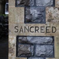
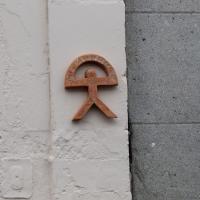
Never heard of the place before I looked it up just now, but apparently Sancreed is a village in Cornwall, 5km west of Penzance.
In Between
06 Feb 2021
A lovely walk in the early spring sunshine with my friend Lisa. We headed directly for Jacobs Wells Road, to start off around the scene of one of our earlier walks, but this time took in Jacobs Wells from QEH upward, stopping to snap some photos of a Bear With Me, some interesting areas between Park Street and Brandon Hill including a peculiarly quiet enclave with a ruined old build I'd never found before, then crossed the Centre to grab take-away pies from Pieminister (I had the Heidi Pie) and head back to my place down the harbourside.
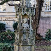
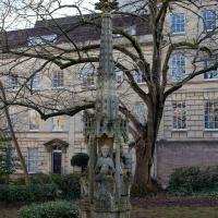
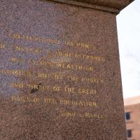
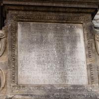
Very long story short: it's a cut-down replica of the Bristol High Cross. The original used to stand in the centre of Bristol, erected in 1373 to commemorate the granting of a charter by Edward III to make Bristol a county, separate from Somerset and Gloucestershire, and now stands in the Stourhead Estate. This replica was made in 1851, and originally sited on College Green.
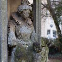
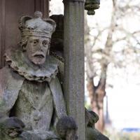
Facing us is Charles I, who used to look down Broad Street, and whose beard appears to have fallen off. On the right is Elizabeth I (Corn Street); on the left, Henry VI (Wine Street), and out of sight around the back is James I (High Street.) Directions and ID courtesy the interesting Wikipedia article.
I found out during later research into the Hughes family (including [James] Donald Hughes, who lived at 23 Berkeley Square) that it was Ellard Hughes, Donald's younger brother, who saved the upper part of the cross from the scrapheap and had it re-erected here. His father, Walter William Hughes, was an estate agent and general man of property with strong College Green connections, including being involved in the purchasing of land for the Council House, now City Hall1. I think it was during that work that the cross was removed from College Green.
This Tweet from Nick Howes shows the full cross standing in the centre of College Green in an aerial photo from 1931-2.
1 Source: A College Green Man, Article by William R Hughes on the many connections his father Walter William Hughes (1833 - 1909)
had with life round College Green, Bristol, Bristol Archives 30508, Deeds and documents of the Hughes family, estate agents of Bristol, 1791-1910.
As in Elizabeth I, who is of course the QE of QEH school from an earlier photograph; the school was founded in 1586. (Though the Bristol HIgh Cross dates from 1373, an extra tier with these four figures was added in 1663, explaing the apparently-paradoxical timeline.)
(Photographic Lack of) Worcester Terrace
09 Feb 2021
A nice walk, but something of a failure, photographically. I went to knock Worcester Terrace off my list, a not dissimilar terrace to Vyvyan Terrace, but one street further away from me. Like yesterday, it was very chilly but this time I went prepared with an extra layer and a winter coat. I think this may have been my downfall, as it may have been the X100T's control wheel brushing against the coat that put it in aperture priority mode at f/16, which I didn't notice at the time, and made most of my photos a little too blurry to use. Apparently in this mode, the X100 doesn't bump up the ISO if it can tell things might be a little too wobbly. Ah well.
So, a nice enough walk, and technically I did Worcester Terrace, but if you didn't take a photograph, were you really there? I'll have to go back...
I went to get my first dose of the Oxford/AstraZeneca Covid-19 vaccine today. Handily, the vaccination centre was Clifton College Prep School in Northcote road, next to Bristol Zoo, a road that's just within my 1-mile range that I hadn't visited before.
I parked up near Ladies Mile and tried to find a few of the tracks marked on the map I'm using, but couldn't see most of them. Whether that's just because they've disappeared over time, or with the recent lack of use or waterlogging from the 24 hours of rain we just had, I'm not sure. It was a pretty fruitless search, anyway.
The vaccine shot was virtually the same setup as when I got my winter flu jab back in November, except for the venue. I snapped a couple of pictures of the school while I was there, but I was in and out in five minutes, and you probably don't want to linger around a vaccination centre, I suppose.
Instead I wandered around the compact block of the Zoo, now sadly scheduled for closure. By coincidence I finished E H Young's Chatterton Square this morning: set in Clifton (fictionalised as "Upper Radstowe") near the Zoo, the occasional roars of the lions that can be heard by the residents of the square (Canynge Square in real life) form part of the background of the novel. The book's set in 1938 (though written and published post-war, in 1947). It seems a shame that the incongruous sounds of the jungle will no longer be heard from 2022. All I heard today were some exotic birds and, I think, some monkeys.
I was told not to drive for fifteen minutes following the jab, so I wandered out of my area up to the top of Upper Belgrave Road to check out an interesting factoid I'd read while looking into the history of the reservoir at Oakfield Road, that the site of 46 Upper Belgrave Road was a bungalow, shorter than the adjacent houses, and owned by Bristol Water, kept specifically low so that the pump man at Oakfield Road could see the standpipe for the Downs Reservoir (presumably by or on the water tower on the Downs) and turn the pump off when it started overflowing. Sadly I couldn't confirm it. There is one particularly low house on that stretch, but it's number 44, and though small, it's two-storey, not a bungalow, so nothing really seems to quite fit in with the tale.
I'm writing this about nine hours after getting the jab, by the way, and haven't noticed any ill effects at all. My arm's not even sore, as it usually would be after the normal flu jab. In twelve weeks I should get an appointment to get the second dose.
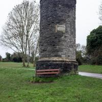
This is a ventilation shaft for the Clifton Down Tunnel. The railway tunnel was opened in 1877, and is still in use. According to this page (which might've been put together by my friend Rob, by the looks of it!): this ventilation shaft used to be topped with crenellations, and also:
Clifton Down Tunnel is 1751 yards long. Halfway along its length there is an opening into a cave that exits half way up the cliffside of the Avon Gorge.
...so that's quite fascinating. I think it also used to connect to the Bristol Port Railway and Pier tunnel that I found in the Avon Gorge on another wander.
EDIT TO ADD (14 Oct 2021): I'm just reading Colin Maggs' The Bristol Port Railway and Pier (Oakwood Press, 1975) and the tunnel was indeed built for the Clifton Extension Railway, which linked the Bristol Port Railway line with the rest of the national network. It sounds like quite a feat of engineering, including the use of a diamond boring machine invented by Major Beaumont, MP: "Cutting facets of black diamonds were fixed round the end of a steel tube to form a kind of auger. This tube was rapidly revolved by compressed air and advanced so that its diamond points came into contact with the rock and water forced through the tube washed away grit and kept the tube cool."
Downs Wander
23 Feb 2021
Just a quick trip to knock off a path or two on Clifton Down. I'm not actually convinced I walked down the paths I was hoping to, but I suppose I'll see once I upload this and look at it on the map :)
Today's highlight turned out to be retrospective—looking up Gertrude Hermes' amazing wood engravings when I got home. (By complete coincidence, I was trying to discover the location of the Stella Matutina's former Hermes Lodge in Bristol as part of my researches last night...)
Of Bridges and Buoys
04 Mar 2021
A trip to Imagine That coffee, so no fresh roads knocked off my list, but I stopped off to snap a couple of the engineering-related bits of the docks: the Campbell Buoy (used by P&A Campbell for mooring their paddle steamers) and Brunel's "other" bridge, the foot/horse swing bridge that now sits sadly disused in the shadow of the Plimsoll Bridge at Howard's Lock.
Leigh Woods Walk
14 Mar 2021
An enormous walk today, or at least it felt enormous. My feet are sore, anyway. I started off recreating a couple of local historical photos in Hotwells, but then headed for my traditional walk along the towpath in the Avon Gorge to the far extreme of Leigh Woods, up and through the woods to the height of the Suspension Bridge, finally crossing into Clifton Village for a well-deserved vanilla latte.
I say "traditional" because this used to be a very regular route for me, first walking, years and years ago, and later jogging—this route combined with a circuit of the Downs on the other side used to be my way of making sure I was fit to do a half-marathon (I did six of them in total, between 2010 and 2014).
I miss the routine of this walk, even though it's a long way and it used to pretty much wipe me out when I did it—I'd come back home and collapse and do very little for the rest of the day. But perhaps that's what Sundays are for, and I should try to remember that.
Doing this walk regularly was quite a meditative experience. Not so much of that today, but once I got to the further extreme of the towpath, where the roar of the Portway traffic on the other side of the river dwindles and I turned into Leigh Woods to climb ever closer to birdsong and further from rushing cars, I did seem to recapture a little of the feeling of previous walks. (I would say my mind cleared, but I was mentally singing along to Life Without Buildings' The Leanover for most of the wander. There are worse songs to have stuck in one's head, though; it's a great track...)
Anyway. Apparently the walk made me more likely to ramble in words, too. I'll stop now :)
John Carr's Terrace
16 Mar 2021
I wanted a nice simple lunch-hour walk that took me past a cafe today, and I managed to find the perfect road to knock off my list of targets to do it. Situated just off Jacobs Wells Road, right next to Queen Elizabeth's Hospital, John Carr's Terrace, and Rosebery terrace above it, which I'd completely forgotten existed, are a little cul-de-sac that many Bristolians will have wandered past a thousand times without ever seeing.
There's a reason it's next to QEH:
Known traditionally as "The City School", Queen Elizabeth's Hospital was founded by the will of affluent merchant John Carr in 1586, gaining its first royal charter in 1590.
John Carr's terrace itself isn't much to write home about, architecturally, but I like the secluded feel of it, and I really liked Rosebery Terrace with its little houses, commanding position and friendly, slightly tumbledown feel.
On the way home I popped into Foliage Cafe for a coffee and a very pleasant nutella and banana pastry, then walked home past the refurbishment of the old Thali Cafe into a new and interesting clinic...
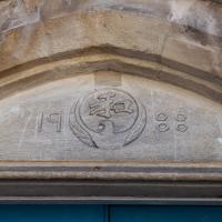
Among other things in its colourful history, the former Brandon Methodist Church was, for a while, the Japan Arts Centre, which probably explains this detail from its tympanum. I remember walking past when it had big adverts outside for martial arts. They used to teach Judo, Aikido and Karate, I think.
I got interested in Bristol's medieval water supplies after poking around near Jacobs Wells Road and Brandon Hill. It was during that research I found out about a pipe that's still there today, and, as far as I know, still actually functioning, that was originally commissioned by Carmelite monks in the 13th century. They wanted a supply of spring water from Brandon Hill to their priory on the site of what's now the Bristol Beacon—Colston Hall, as-was. It was created around 1267, and later, in 1376, extended generously with an extra "feather" pipe to St John's On The Wall, giving the pipework its modern name of "St John's Conduit".
St John's on the Wall is still there, guarding the remaining city gate at the end of Broad Street, and the outlet tap area was recently refurbished. It doesn't run continuously now, like it did when I first moved to Bristol and worked at the end of Broad Street, in the Everard Building, but I believe the pipe still functions. One day I'd like to see that tap running...
There are a few links on the web about the pipe, but by far the best thing to do is to watch this short and fascinating 1970s TV documentary called The Hidden Source, which has some footage of the actual pipe and also lots of fantastic general footage of Bristol in the seventies.
On my walk today I was actually just going to the building society in town, but I decided to trace some of the route of the Carmelite pipe, including visiting streets it runs under, like Park Street, Christmas Street, and, of course, Pipe Lane. I also went a bit out of my way to check out St James' Priory, the oldest building in Bristol, seeing as it was just around the corner from the building society.
There are far too many pictures from this walk, and my feet are now quite sore, because it was a long one. But I enjoyed it.
I bumped into my friend Lisa in town during yesterday's wander, and we decided to have a wander today, too. We managed quite a long ramble, starting up through Clifton and nipping down Park Row to investigate the two tower blocks I'd noticed popping up behind Park Street yesterday, then took in a few roads I'd not managed to get to before, including cutting through the grounds of Bristol Grammar School.
