Tagged: fluvial-landforms-of-streams
Man on a Mission
17 Apr 2021
I went rather outside my area today, as I went to pick something up from the Warhammer shop on Wine Street (Games Workshop as-was, and before that I think perhaps a rare retail outlet for Her Majesty's Stationery Office? I may be mis-remembering...) Anyway, a friend of mine wanted something picking up and posting to him, so I figured I'd knock some streets off my list along the way.
I first headed for the St George's Road area, walking down the narrow Brandon Steps and finding some strange wall art on Brandon Steep, then headed to the Old City via Zed Alley. The Warhammer shop visit was friendly and efficient, and, mission accomplished, I treated myself to a sausage roll and a flat white from Spicer + Cole, to take away and eat in Queen Square with its current decoration of hearts. I finished off with a detour up Park Street, looking out for St John's Conduit markers, before finally crossing Brandon Hill on the way home.
Quite a long wander, all told, and I'm a bit knackered today...
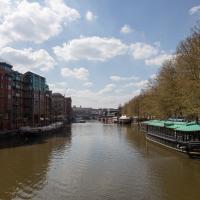
Another Day, Another 50 Metres
29 May 2021
I met my friends Sarah and Vik at Riverside Garden Centre today; I needed to buy some compost for repotting my wildly-overgrowing aloe vera, and I went a little bit out of my way to knock off a stretch of Ashton Road. It was a pleasant enough walk in the surprisingly warm (and surprising-not-tipping-it-down-on-a-Bank-Holiday-weekend) weather.
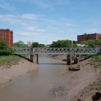
It looked pretty amazing back in the day; it was a double-decker swing bridge with a control tower raised over the swing point. Here's another old snap, this one from a more similar viewpoint to mine.
When I moved to Hotwells, it was a pedestrian-only bridge, though one half of it still had the overgrown rail tracks from when it was a bottom-deck railway and top-deck road bridge. Since then it's been refurbished and is now combined pedestrian and Metrobus, with a guided channel for the buses. Amusingly, when it was first put in, they managed to make it too narrow for the buses. In fact, it's closed right now for "works on the guideway" so presumably they're still having problems.
Bank Holiday Street Art
31 May 2021
A nice warm Bank Holiday Monday saw me walk back over to Bedminster to do justice to something we glimpsed on my last wander. Along the way I spotted a couple of new pieces of street art tucked away on the south side of the Cumberland Basin Flyover system, so this turned into a micro-graffiti walk.
Leigh Woods Solo
19 Jun 2021
I hadn't really planned to go out for a wander yesterday; I just got the urge and thought "why not?" (Well, the weather forecast was one possible reason, but I managed to avoid the rain, luckily.)
I wanted to finish off the A369—as it turns out I may still have a small section to go, but I've now walked the bulk of it out to my one-mile radius—and also a few random tracks in Leigh Woods. I'm still not really sure that I'm going to walk them all, especially after discovering today that "the map is not the territory" applies even more in the woods, where one of the marked tracks on the map wasn't really that recognisable as a track in real life... I'm glad I'd programmed the route into the GPS in advance!
Anyway. A pleasant enough walk, oddly bookended, photographically at least, by unusual vehicles. Leigh Woods was fairly busy, especially the section I'd chosen, which was positively dripping with teenage schoolkids with rah accents muttering opprobrium about the Duke of Edinburgh. I'm presuming the harsh remarks were more about taking part in his award scheme than the late Consort himself, but I didn't eavesdrop enough to be certain...
I took this as a comparison shot for this non-OMM photo I snapped the other night, to show how much difference the right conditions can make to a photograph :D
Shops, Hedgehogs and Cows
06 Jul 2021
I really only took the GPS and camera on a "just in case" basis, as I knew I was only going for a coffee in Greville Smyth Park along a well-trodden path this lunchtime. Still, I saw a few new things along the way, so I figured it was worth uploading the handful of photos I took...
Pastures New!
17 Jul 2021
Okay, not much in the way of actual pasture to be had in Bedminster these days, like most of Bristol, but I did take advantage of the current rather toasty weather in Bristol to go and sit under a tree in Greville Smyth Park to read a book for a while before firing up the GPS and taking a little detour around some back streets of Ashton and Bedminster rather than going straight to Coffee #1 for an espresso frappé. This is the first walk in a while where I've actually crossed off an entire new street (the frankly unexciting Carrington Road) as well as exploring a couple of back alleys, just because they were there, really. Along the way I spotted a few examples of graffiti of various qualities, including a live work-in-progress by SNUB23 on Ashton Road and the finished Six Sisters project on North Street.
They've not made much progress on repairing the Chocolate Path, sadly, but it seems they've at least got a budget and a green light now.
The entire New Cut only took five years to dig out, but on the other hand they had literally a thousand men on the job and I imagine several of them died. Probably have to be a bit more careful these days.
A Long Wander Of Miscellany and Magick
08 Aug 2021
This was a wide-ranging wander. I started off crossing the river to Bedminster, to walk a single little cul-de-sac, Hardy Avenue, that I'd managed to miss on at least one previous walk. Then, pausing only to explore a few back alleyways, I headed for a few destinations related mostly by the Hughes family, who I've been researching a little as part of background for a possible novel, as several of them were involved in the Stella Matutina.
However, mostly it's the artistic side of the family I wanted to explore today, as that's where most of their public history lies (as you might expect, there's often not much in the public record about the workings of an occult organisation.) First I visited College Green, where the façade of the Catch 22 Fish & Chip shop still bears the work of Catherine Edith Hughes. Then I wandered up to the top of Park Street to pop into the Clifton Arts Club's annual exhibition, as Catherine, her half-brother Donald, his wife Hope and at least two other Hugheses were members. Donald was chairman for 40 solid years; Hope was Secretary for eight, and Ellard and Margaret Hughes, two more Hughes siblings, were members along with Catherine.
Finally I walked home with a small diversion to Berkeley Square, to confirm the location of Donald Hughes's house by checking for a particular plaque by the front door.
I must admit I'm not entirely sure where all this research is really leading me, but I'm finding it quite interesting to bump across the faint lines of history that link the Hermetic Order of the Golden Dawn, founded in 1888, to modern, quotidian Bristol.
Ticking Off a Few Streets in Bedminster
31 Oct 2021
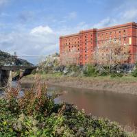
There were only a few streets left to wander in the more residential bit of Bedminster, so I thought I should target those today. The streets themselves weren't that notable, though Balfour Road has a contrasting mix of old and new housing. I tried to snap a few more interesting things along the way there and back, snapping all three of the familiar bond warehouses, nipping onto North Street to find some new street art, and finding a few pumpkins for good measure. It is hallowe'en, after all...
I went out simply wanting to knock off the very last little unwalked section of Clanage Road, over by Bower Ashton, which has been annoying me for a while as it's quite close by and I've walked the other bits of it several times. So, my plan was to nip over to Greville Smyth Park via a slightly unusual route to wander Clanage Road and tick it off.
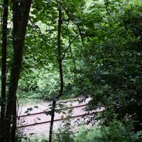
Along the way, though, I inevitably got a bit distracted. I took a few photos of Stork House, a grand Hotwell Road building that's recently been done up a bit (I imagine it's student lets, though I'm not sure) and which I found a reference to in a book about the Port Railway and Pier the other week, and also tried to match up a historical photo of Hotwells before the Cumberland Basin Flyover System laid it waste, which included some interesting markers I'll have to do a bit more digging into...
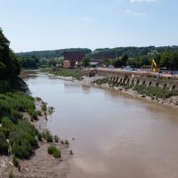
Former site of the Rownham Ferry, or one of them, at least. The ferry was there for centuries before being rendered obsolete by the Ashton Avenue Bridge, among others. King Charles allegedly crossed it in 1651, on his way to Leigh Court, but it was there for a long time before and after, closing in the 1930s.
The more I research it, the more I find that Hotwells had far better transport links back in Victorian and Edwardian times than it has today. Along with buses that went to more useful places than the City Centre, there were trams, the funicular up to Clifton, the landing stage for paddle steamer services and two railway stations all within easy walking distance of me.
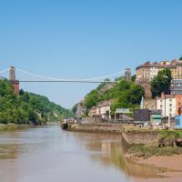
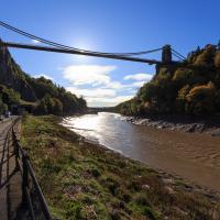
Today I took a day off work as preparation for doing the bookkeeping for my tax return1, and took a wander along to the site of what would have been my nearest station, Hotwells (or Clifton, as it started out in life), nestled in the shadow of the suspension bridge, the Bristol terminus of the Bristol Port Railway and Pier.
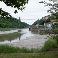
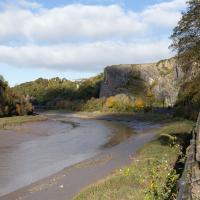
From there I wandered down the Portway, following the original line, until I got to the area around Sneyd Park Junction, where the tunnel from the slightly later Clifton Extension Railway joined up with this originally-isolated BPR line. Then I headed up to Clifton through the "goat gully" at Walcombe Slade, seeing the few above-ground bits of evidence of the tunnel (which is still in regular use) along the way.
It was a lovely day, and a good walk, and it was interesting to daydream of the times when I could have walked a few minutes from my flat down to Dowry Parade, caught a short tram ride to Hotwells Stations, and then headed from there to Avonmouth, perhaps even to board a transatlantic passenger service. The completion of the Clifton Extension Railway that linked the Avonmouth station with Temple Meads made relatively direct transatlantic travel from London via Bristol possible, with passengers travelling up from Paddington to Temple Meads, on to Avonmouth on the Clifton Extension Railway and Port Railway and Pier line, then perhaps catching a Cambpell's paddle steamer—which sometimes acted as tenders for large steamers—to a larger ship that was headed out for Canada, say.
1 I've learned that the best approach is to take two days off and deliberately do something that's not my bookkeeping on the first day, as otherwise I just inevitably end up procrastinating and feeling guilty on the first day no matter what. I have an odd brain, but at least I'm learning strategies for dealing with its strange ways as I get older...
2 Information mostly gleaned from Colin Maggs' The Bristol Port Railway & Pier and the Clifton Extension Railway, The Oakwood Press, 1975.
A last look back the way we came. Bristolians would have either walked to the station taken the tram; the tram rails ended just this side of the Gallery, from what I can make out from other pictures I've seen.
Here's one more interesting thing: it's just as well for me personally that the railway terminated in Hotwells. One of the original plans, which you can see in beautiful detail here, by clicking on the Community Layer pop-up in Know Your Place was for a tunnel under Clifton that would pop out about where Hotwells Primary School is and then run on to Temple Meads. Why would that be bad for me? Well, I reckon the tunnel would pass directly through my bathroom, bedroom and living room...
(That map, incidentally, by John Lavars, was popped on the Community Layer of KYP by my friend Dave. It's a shame that there doesn't seem to be a way to see who uploaded an item to the community layer, or see any more details about it...)
That's Sneyd Park up in the distance. We're heading that way to join up with the nearest extant bit of the Port Railway.