Tagged: girder-bridge
Bower Ashton is an interesting little area just south of the river from me—in fact, the Rownham Ferry used to take people over from Hotwells to Bower Ashton, operating from at least the twelfth century to around the 1930s.
It's a strangely contradictory little area, with a cluster of old and new houses sandwiched in between the busy A-roads and significantly more industrial area of Ashton and the bucolic country estate of Ashton court roughly east to west, and also between Somerset and Bristol, north to south.
I've been around here before, mostly poking around Bower Ashton's arguably most well-known bit, the Arts faculty campus of the University of the West of England, but I'd missed at least Parklands Road and Blackmoors Lane, so I initially planned just to nip across briefly and wander down each in turn. On a whim, though, I texted my friends Sarah and Vik in case they were out and about, and ended up diverting to the Tobacco Factory Sunday market first, to grab a quick flat white with them, extending my journey a fair bit.
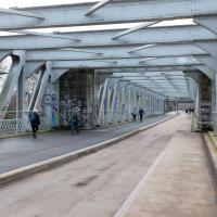
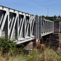
To start with, though, I nipped to a much more local destination, to see something that you can't actually see at all, the Gridiron...
(I also used this wander as a test of the cameras in my new phone. I finally upgraded after a few years, and the new one has extra, separate wide and telephoto lenses compared to the paltry single lens on my old phone. Gawd. I remember when speed-dial was the latest innovation in phones...)
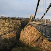
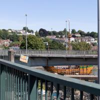
I decided to try out the three lenses on my new iPhone camera. This is the "telephoto" lens. It does a reasonably creditable job, though the phone is oversharpening things a bit and I'm not sure I like the colours much.
The Gridiron and Bower Ashton Part Two
03 Dec 2021
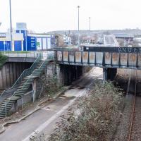
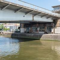
On my last wander, to Bower Ashton, I was intending to knock Blackmoors Lane off my list "to-do" list, but got a bit diverted. I also took a little look into the history of the Gridiron, once a cheaper alternative to dry dock that was nestled just south of North Entrance Lock.
Today I had to go to send a parcel off somewhere, so I decided on going to the North Street Post Office via Blackmoors Lane. I didn't have much intention of anything else, but as luck would have it I walked out both at low tide and also as some lockkeepers seemed to be having a bit of a training session, and one of the more senior people was (a) happy to answer a few random questions on the Gridiron and (b) actually knew a lot about it, as Gridiron maintenance had been one of his jobs, more than twenty years ago...
My friend Lisa texted me to see if I wanted to pop down and take a photo or two of the event she was taking part in: Santa SUP. SUP Bristol organise stand-up paddleboarding on the floating harbour, and their annual Santas-on-paddlboards event is quite the sight.
On the way there, I grabbed a historical photo I'd been wanting to recreate for a while of the shiny and new Cumberland Basin flyovers back in 1965, because I reckoned I could fit finding the same viewpoint into my outbound journey. Also, after having only used it on a wander for the very first time yesterday, I managed two crossings in the cross-harbour ferry today to get to the best locations for snapping the paddleboarders...
So, then, this wander is mostly a bunch of photos of paddleboarding Santas. Tis the season... Enjoy!
So, mostly this wander will be a panoply of photos of my friend Lisa and her paddleboarding friends making their way around the harbour dressed in Christmas outfits. But, on the way, I figured I'd try to reproduce another historical photo.
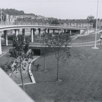
This one's from the Bristol Archives' collection of council Public Relations photos. Its title is "The northern side of the Cumberland Basin Bridges Scheme: Completed and landscaped, 1965".
I find that this actually looks quite nice, all clean and shiny and new. It probably looks very similar to the architect's drawing and scale models and what-have-you that they produce for these sorts of things.
Via Bristol Archives/Know Your Place.
A Constitutional to Burwalls and Back
21 Dec 2021
The recent lack of posts here is mostly due to my feeling very run down following having a couple of wisdom teeth extracted. Having had an emergency appointment yesterday1, hopefully I'll be on the mend now, though it does mean I'm on the kind of antibiotics where you can't touch alcohol for the whole of the Christmas period. I have tried to keep myself a little distracted from the pain by working on the nuts and bolts of this website—you should notice that the front page loads rather faster now than it used to, and that there's a shiny new statistics page that I'll probably be continuing to work on. Oh, and you should find that the tags below the photos are now clickable and will take you to a page of all other wanders that have photos with the same tag.
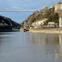
Today I felt like I needed to drag myself out of the house, but I didn't want to go too far, and I needed to get to the Post Office up in Clifton Village to post a Christmas card (spoiler for my parents: it's going to be late. Sorry.) As luck would have it, idly looking at the map I spotted that I'd missed off a section of Burwalls Road in the past, and that's basically one of the long-ways-round to Clifton Village, crossing the river to Rownham and walking up the hill on the Somerset side before coming back across the Suspension Bridge.
As I was heading for Burwalls Road I decided to make Burwalls itself the focal point of the walk, but unfortunately the mansion grounds are private and the place is hard to snap. Still, at least it gave me a destination. Burwalls was the mansion built by Bristol press magnate Joseph Leech, who I've mentioned before after buying a vintage book he wrote on a previous wander. There's a good article about the house on House and Heritage which has some photos from angles I couldn't ever get to. (Well, maybe with a drone, but it seems like the kind of area where they may be kitted out for clay pigeon shooting, so I probably wouldn't risk it.)
1 My dentist admitted that she probably needed to keep her internal monologue a bit more internal after we started the appointment with her staring into my mouth and immediately saying, "oh, *that's* weird." These are words one doesn't want to hear from a medical professional.
A Random New Year's Day Wander
01 Jan 2022
I picked a fairly arbitrary reason for a wander today. Really, I just wanted to do a New Year's Day wander just to get out of the house and to set a precedent for the year to come.
My ostensible reason was to investigate what looked like a road on my map that quartered the lawn in front of the Ashton Court mansion. As it turned out, this is just a muddy footpath/desire line similar to a half-dozen other tracks nearby, and must be some kind of bug or misclassification with the mapping system I'm using, but that's not important. What's important is that I went for a little walk on the first day of the year. As a bonus, I did happen to wander down a couple of sections of new footpath, so technically I broke some new ground too, which is nice.
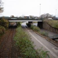
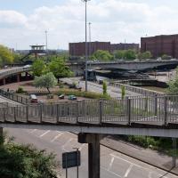
The somewhat unholy trinity of the A3029, the metroBus route and the Portishead branch line. I'm not sure what anyone could do to make this view uglier. Suggestions on a postcard to the council, perhaps?
Leigh Woods Purple Path
12 Mar 2022
There's a few tracks in Leigh Woods that lie within my mile and show up on my map but that I've not walked yet, so I decided to take one of my traditional big long walks through the woods on this nice crisp sunny morning.
For years—decades, even—I've been doing a similar route from my place, along the towpath to the far woods entrance, up the hill for a varied walk on one of the marked tracks and then across the Suspension Bridge to Clifton Village for a coffee-based reward. It's my default "long walk", really, and I almost always enjoy it. Today, at last, spring actually seemed to be springing, which made for some extra positivity...
I'm sure both the entire flyover system and its monument bench looked splendid when they were first put up, in 1965.
Here you can hear a live performance of the song Virtute et Industrial by Adge Cutler and the Wurzels that includes a brief reference to the then-newly-completed flyover system:
Hast seen our brand new bridge, up there in Cumberland Basin?
The cars go by like thunder, and up and round and under
Where they goes, nobody knows, tain't no bleedin' wonder!
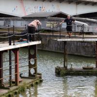
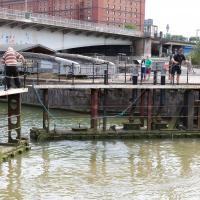
A Swing of the Plimsoll Bridge
24 Apr 2022
I was originally going to head over to the Ashton area to see if I'd missed any bits around the football stadium—and also to grab some lunch from the Tobacco Factory Market—but in the end I got a little distracted by having accidentally chosen exactly the right time to see the Plimsoll Bridge swing on one of the first busy days of Spring, where a lot of pleasure trips tend to head out down the Avon (and possibly the New Cut) from Hotwells.
In the end I mostly snapped that, and just a couple of photos from the Ashton area where I grabbed some lunch but didn't do any new exploring.
I've been pretty awful at reading so far this year, apparently averaging about one book per month. That's a far cry from 2019, say, where I got through 41 books in the year. Today's wander was prompted by my rubbish reading, as I needed to go hand back some books to the library, because I'd managed to renew them so many times that I hit the limit on renewals. Oops. Several of them were still unread.
So, off to the Central Library for me, tail between my legs. On the way there I did my best to recreate a historical photo of Dowry Square; while I was in the area I walked under the adjacent Norman arch and poked around behind the Cathedral, and I also had a little diversion to the city centre and came back along the south side of the river, hitting some trouble with the lock gates as I finally crossed the harbour back towards home.
I'm in the habit of going over to the Tobacco Factory Market on a Sunday. I think I've walked all the routes around that way, but as a Plimsoll Bridge swing let me cross the road to the far side of Brunel Way on my return journey and I took a couple of photos of the brownfield development at the old Ashton Gate Depot site I thought I'd call it a Wander and pop some photos up.
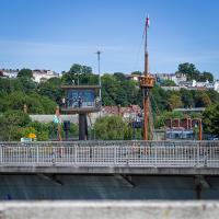
One of the things I like about Bristol is the strange contrasts. Here we have two crow's nests. The first is the Cumberland Basin Flyover System's Plimsoll Bridge control room, used to give the swing bridge operator a good view of the whole area surrounding the bridge. The second is the reason for the swing, the crow's nest on the tall mast of the replica of John Cabot's Matthew, as it passes through into Entrance Lock.
Nipping Up the Zig Zag to the Shops
19 Aug 2023
It's been a long while since I did one of these walks.
I'm thinking of finishing up the project by walking one or two last bits of road, thus being able to declare with all honesty that I've done my best to walk every public road within my mile (and quite a few alleyways besides.) As a prelude, and just because I felt like it, I decided to drag out the camera and GPS on this little wander to the local shops.
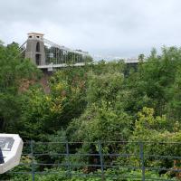
The reward at the top is the viewing platform of the Suspension Bridge, always busy with tourists.
I was actually planning to take an unexpected short-cut through a pub as an interesting little diversion on this wander, but sadly the pub was closed—I suppose before midday it's a bit of a reach to expect any pub to be open, even on a Saturday—so I headed for the shops instead. I'll have to do the short-cut trip one afternoon...
First I browsed the books at Rachel's & Michael's Antiques on Princess Victoria Street, where I bought CFW Dening's Old Pubs of Bristol as it mentions Hotwells a few times, then I grabbed my lunch from Parsons Bakery. There didn't seem to be anything new or interesting to snap along the way, so we'll now skip to the last couple of photos I took on my way home...