Tagged: landmark
On Christmas Day in the Morning
25 Dec 2020
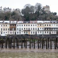
A Christmas Day walk with my friends Sarah and Vik, taking in the shipwrecked Shadow and a hilly chunk of Leigh Woods.
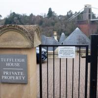
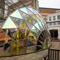
I went to have a peep at the giant sinkhole that's opened up in Canynge Square—ironically, having recently discovered the gardens were public I'd had the (triangular!) square on my list to re-visit for a few days, but now there's no entrance to the gardens due to the danger. The area was well fenced-off for safety, but I tried to get a couple of photos from behind the barriers.
I also explored the area around Camp Road, an real melange of architectures, one of the most mixed-up areas I've seen in Clifton, in fact, and confirmed my friend Claire's suspicion that an earlier snap of a sign from Manilla Road was in fact for a fire hydrant. Nice.
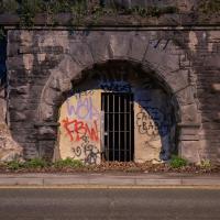
My historical research took a wander underground recently, partly inspired by the Canynge Square sinkhole, partly by St Vincent's (Ghyston's) cave and its tunnel to the Observatory, and I was surprised to find that there might be an intact tunnel from the Bristol Port Railway and Pier still just sitting there under Bridge Valley Road. A quick search turned up this recent video by an intrepid explorer, so it's definitely still there.
I went looking for the entrances today, and definitely found the south entrance, at the start of the Bridge Valley Path, the footpath that starts with steps at the bottom of Bridge Valley Road. It's easy to miss if you're not looking for it. I think I've figured out where the north entrance is, too, but it was getting dark at that stage and the Portway was still busy enough that crossing the road was still the normal nuisance, so I thought I'd leave further explorations for another day.
A fragment from Horace's Odes: "not taught to suffer poverty."
Wikipedia says that the defunct Bristol magazine Venue once did a bit of investigative journalism on them:
Venue claimed that the Merchant Venturers control 12 charities and 40 trust funds, and also a private unlimited company, SMV Investments, that has major investments in defence contracting, tobacco, genetically modified agriculture and the petroleum industry. Merchant Venturers serve on the boards of many local charitable and cultural organisations, and are guaranteed seats on the University of Bristol Court and the Downs Committee. It quotes Paul Burton of the University's School of Policy Studies as saying, "they exert quite a bit of influence and we, the people of Bristol, don't know much about them and can't hold them to account"
A Promenade on New Year's Day
01 Jan 2021
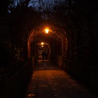
I wandered along the gorge today and found the entrance to the disused Portnalls Number 1 railway tunnel of the Bristol Port Railway and Pier. The door was unlocked, but as soon as I opened it I felt a sense of current habitation and decided discretion was the best option. There's a lot of people homeless in Bristol at the moment, and they don't need disturbing. For the same reason, I've omitted posting some pictures of a little encampment somewhat off the beaten track of the new Zig Zag, where I reversed direction as soon as I realised I'd come across a current habitation of some sort.
Up in Clifton it took me a little while to work out that the picture of the Promenade I was trying to reproduce was taken from the viewpoint I'd thought, it was just that the Alderman's fountain was moved from the top of Bridge Valley Road to the other side of the promenade in 1987, so trying to use it as my initial landmark wasn't very helpful!
Finally I swung past the Society of Merchant Venturers, who presumably still own most of Clifton, having bought the entire manor, including Clifton Down, in 1676, and I imagine aren't in much danger of running out of money. That's true to their motto: indocilis pauperiem pati is apparently from the Odes of Horace, and translates as "will not learn to endure poverty"...
Prince's Lane
06 Jan 2021
The International Grotto Directory website says:
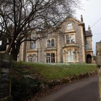
Prince’s Lane might have been one of the original ancient tracks from Hotwells to Clifton, in the Avon Gorge. The site later formed part of Rownham Woods which comprised some thirteen acres. By the end of the 18th century and the early 19th century, the Society of Merchant Venturers granted to Samuel Powell a building lease, for The Colonnade (1786), St. Vincent’s Parade (1790), Prince’s Buildings (1796), and Rock House. Rock House is generally considered to be the oldest surviving building associated with the Hotwell (see Chapter 20). John Power conveyed part of the woods to William Watts for the construction of Windsor Terrace (1790-1808).
The above development of the Avon Gorge cleared Rownham Woods, and created a triangle of land on the north side of the gorge, that became enclosed as a result, by Mansion Houses, whose garden walls all entered on to Prince’s Lane. The Lane started at the bottom of the gorge, at the base rock of Windsor Terrace, and came out half way up Sion Hill. It is clearly shown as a public footpath, dotted with trees, in Ashmead’s map of 1828. Some of the gardens were quite steep in parts and therefore, had to be terraced, because of the gradient of the gorge.
I've passed Prince's Lane literally thousands of times in my life, every time I've walked past the Avon Gorge Hotel, which itself started (in 1898) as the Grand Clifton Spa and Hydropathic Institution and pumped water up from the Hot Well for its hydropathic treatments. I've never actually ventured down it until today, or at least nothing like as far down it as I did this afternoon—I may have poked my head around the back of the hotel to see the original pump rooms at some point in the past.
This was a great wander, though it does very much feel like a private road, and frankly I may have been pushing my luck a bit by winding my way between the astoundingly big back gardens of the houses of some presumably very wealthy Cliftonites, but I felt vaguely justified in exploring the history of one of the oldest footpaths in my part of Bristol...
Morning Walk
08 Jan 2021
Tempted by a hopeful repeat of yesterday's weather, I got up early this morning and went for a short walk up into Clifton Village, around Observatory Hill, back down the Zig Zag and home. Instead of beautiful and mysterious fog and crisp freezing brightness I got some murk and slight dampness which included witnessing a road-raging van driver and finding that it still wasn't cold enough for the hot well to be even gently steaming when I got down there. I've still never seen it steaming, but I've been told it does, on colder days.
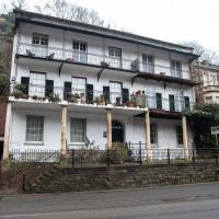
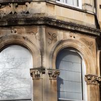
The way the left-hand side looks a lot more together than the right-hand side may be explained by the very first part of the listing:
Rock House, now divided into 2. c1800. Render with limestone dressings, roof not visible. Double-depth plan. Late Georgian style. 3 storeys and basement; 5-window range. A symmetrical front has pilaster strips to a moulded coping, a wide basement area with Pennant-stepped bridge to an elliptical-arched doorway with metal batswing fanlight and 2-leaf 12-panel door with fluted lower panels. In front of the basement area is a later colonnade of 6 slim Tuscan columns, square to each end, to a deep first-floor balcony, and a shallow, tented second-floor balcony on cast-iron brackets with flat stanchions, both with pointed-arched wrought-iron railings with quatrefoils; 8/8-pane ground-floor sashes, French windows above, and plate-glass basement sashes.
However, I've found several references that suggest that even Historic England's estimate of the date of the property is wrong. I just found one in a planning document, part of an objection to a planning application related to Prince's Lane by the Cliftonwood and Hotwells Improvement Society:
Rock House (412 Hotwell Rd) is shown in an early engraving by William Halfpenny in 1731 so is much older than any of the neighbouring buildings and is the sole survivor of the original Hotwell Spa. It is incorrect to say it dates from 1800, and the planners have been told this.
I haven't, sadly, tracked down the engraving itself.
Mirror Maze
10 Jan 2021
Went for a wander with my friend Lisa—the current lockdown rules seem to be that one local walk for exercise per day with a maximum of one person not in one's "bubble" is fine—up to the University of Bristol area right at the edge of my one-mile perimeter to see the Jeppe Hein Mirror Maze, among other things. On the way we mused about Merchant Venturers, the slave and tobacco trades, and dating in the time of Covid.
I once did a segment on how to photograph lightning from an editing suite at the BBC, which I think was somewhere up there. It was for a programme called Wild Weather of the West, I think, presented by BBC weatherman Ian Fergusson.
I'm not entirely sure where I was as the BBC complex behind this fairly normal-looking buiilding is actually a very large facility that takes up most of the block behind this road, and has a canteen building, the Points West studio and all sorts. I've been in there a few times, for various reasons, including, improbably, having a Greek lesson with Chris Searle, who himself presented the BBC's Greek Language and People decades before...
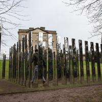
The thing I came here to see was disappointingly small, frankly, but the effect of walking through it was pretty interesting.
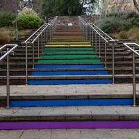
The Cantock Steps annoyed me from the get-go. Walking down them it was apparently they'd not been designed by anyone with an anounce of anthropometric sense, and it's pleasant to find that someone else hates them enough for the same reason that they wrote this diatribe about them.
Having just re-watched the whole of Jonathan Creek, I'd be very much in the mood for this if we weren't in a nationwide lockdown.
Northern Clifton
16 Jan 2021
A raggedy wander with my friend Lisa, picking up a few stray streets and venturing only briefly onto Whiteladies Road, where it was too damn busy, given the current pandemic. We retreated fairly quickly. Found a couple of interesting back alleys, and got a very pointed "can I help you?" from a man who was working in his garage in one of the rather run-down garage areas behind some posh houses, and clearly didn't want us just wandering around there.
This is Lime Walk, a well-known path through St Andrew's Churchyard.
A lot of people call it Birdcage Walk now, and I think that's even on Google Maps, which just goes to show that places are called what people call them. The original Birdcage Walk is just opposite, running across the centre of Victoria Square, and I think it might even still have a sign up with its name on. But something that just looks as Birdcage Walk-ey as this is likely to claim the name in the long run, I'd've thought.
Snowy Leigh Wander
24 Jan 2021
I started this wander with my "support bubble" Sarah and Vik, after Sarah texted me to say "SNOW!" We parted ways on the towpath and I headed up into the bit of Leigh Woods that's not actually the woods—the village-like part in between Leigh Woods and Ashton Court, where I'd noticed on a map a church I'd not seen before. I found St Mary the Virgin and quite a few other things I'd never experienced, despite having walked nearby them many, many times over many years, including a castellated Victorian water tower that's been turned into a house...
Jacob's Well Wander
01 Feb 2021
I just wanted to get some exercise, really, so I set out to knock off the lower bit of Jacobs Wells Road that I'd not managed to walk up yet. I set the new signboard that the community association had had erected as my destination, after reading about it on their blog.
As it turned out, I couldn't even read it, as the building that houses the actual Jacob's Well had water flooding out onto the pavement. I wonder if it was actual Jacob's Well water? Have the soles of my walking shoes been mystically blessed now?
You can't see much of the flood in the photos I snapped, but I did shoot a little video, too. Ed on Twitter said:
I spoke to the seller at the time with a view to buying it - I mentioned an old friend who grew up nearby remembers it flooding regularly. He swore blind my friend was wrong.
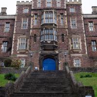
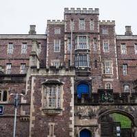
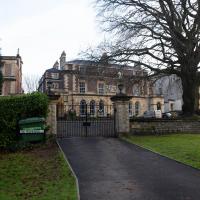
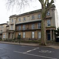
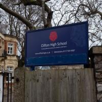
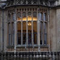
Main entrance to Queen Elizabeth's Hospital. One of those buildings that's easier to take photos of from significantly further away.
I wonder if anyone's ever rushed some wounded person in there looking for the casualty departement, only to find it's actually a school?