Tagged: mode-of-transport
A Constitutional to Burwalls and Back
21 Dec 2021
The recent lack of posts here is mostly due to my feeling very run down following having a couple of wisdom teeth extracted. Having had an emergency appointment yesterday1, hopefully I'll be on the mend now, though it does mean I'm on the kind of antibiotics where you can't touch alcohol for the whole of the Christmas period. I have tried to keep myself a little distracted from the pain by working on the nuts and bolts of this website—you should notice that the front page loads rather faster now than it used to, and that there's a shiny new statistics page that I'll probably be continuing to work on. Oh, and you should find that the tags below the photos are now clickable and will take you to a page of all other wanders that have photos with the same tag.
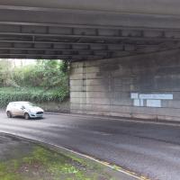
Today I felt like I needed to drag myself out of the house, but I didn't want to go too far, and I needed to get to the Post Office up in Clifton Village to post a Christmas card (spoiler for my parents: it's going to be late. Sorry.) As luck would have it, idly looking at the map I spotted that I'd missed off a section of Burwalls Road in the past, and that's basically one of the long-ways-round to Clifton Village, crossing the river to Rownham and walking up the hill on the Somerset side before coming back across the Suspension Bridge.
As I was heading for Burwalls Road I decided to make Burwalls itself the focal point of the walk, but unfortunately the mansion grounds are private and the place is hard to snap. Still, at least it gave me a destination. Burwalls was the mansion built by Bristol press magnate Joseph Leech, who I've mentioned before after buying a vintage book he wrote on a previous wander. There's a good article about the house on House and Heritage which has some photos from angles I couldn't ever get to. (Well, maybe with a drone, but it seems like the kind of area where they may be kitted out for clay pigeon shooting, so I probably wouldn't risk it.)
1 My dentist admitted that she probably needed to keep her internal monologue a bit more internal after we started the appointment with her staring into my mouth and immediately saying, "oh, *that's* weird." These are words one doesn't want to hear from a medical professional.
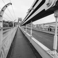
Most every time I cross the bridge, I remember one of the first times I walked over it, back in the late 1990s or early 2000s, when some wag—possibly even Banksy, who knows?—had painted a sign on the footway about here: a rectangle of yellow caution stripes containing the words "WARNING. CONCEALED TRAPDOORS IN OPERATION".
I was just about starting to feel better—the antibiotics seemed to have kicked in for my dental issues, and it had been some days since I'd left the house, and I was at last starting to get itchy feet. So, a wander. But where? Well, there were a few industrial bits near Winterstoke Road in the Ashton/Ashton Vale areas of Bristol that needed walking. I knew they were likely to be quite, well, unattractive, frankly. So why not do them while I wasn't feeling exactly 100% myself? Maybe it would fit my mood. Hopefully you're also in the mood for a bit of post-industrial wasteland, for that's what some of this feels like...
Then, at the last minute, I thought again about the Bristol International Exhibition—I've got a book about it on the way now—and that gave me another goal, which could just about be said to be in the same direction, and I decided to walk significantly further than my normal 1-mile limit and try recreating another historical photo...
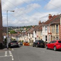
Sadly I don't know much about the Ashton area; it's just on the edges of my mile and I rarely have cause to go there. It's brimming with history, I'm sure: the whole South Bristol area rapidly developed from farmland to coal mines to factories to its current interesting mixture of suburbs and industrial work over the last few hundred years. As a more working class area less attention was paid to it by historians, at least historically-speaking, than the Georgian heights of Clifton, and much of it has been knocked down and reinvented rather than listed and preserved. I see here and there some of this lack is being addressed, but I'm afraid I'll be very light on the history myself on this wander, as most of my usual sources aren't throwing up their normal reams of information as when I point them at Clifton, Hotwells or the old city.
This area continues to be blighted with ugly and neglected-looking infrastructure. We're just on the edges of Ashton Vale, which is among the 30% most deprived areas in the country. At the north of my one-mile radius we have Clifton, among the least 20% deprived. Source: UK indices of deprivation.
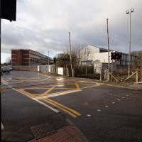
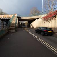
I did know this existed at some point, I think, but I'd completely forgotten that there was a level crossing within my mile. We need to wander over it, too, as this road, Ashton Vale Road, is one of the roads within my mile that I've not ventured down yet.
Partly that's because no bugger wants to walk down roads like this with me, as it's basically just industrial wasteland, especially in this interregnum period, where there's not even the buzz of industry to keep things interesting, but seeing as we're here...
A Random New Year's Day Wander
01 Jan 2022
I picked a fairly arbitrary reason for a wander today. Really, I just wanted to do a New Year's Day wander just to get out of the house and to set a precedent for the year to come.
My ostensible reason was to investigate what looked like a road on my map that quartered the lawn in front of the Ashton Court mansion. As it turned out, this is just a muddy footpath/desire line similar to a half-dozen other tracks nearby, and must be some kind of bug or misclassification with the mapping system I'm using, but that's not important. What's important is that I went for a little walk on the first day of the year. As a bonus, I did happen to wander down a couple of sections of new footpath, so technically I broke some new ground too, which is nice.
Lunchtime Reproduction (of an old photo...)
17 Jan 2022
This was basically the quick lunchtime jaunt I tried to do at the beginning of January, only this time I actually managed to get to roughly the viewpoint I'd been hoping for to recreate a historical photo of the Bristol International Exhibition.
I did this walk about a month ago, but I've been a bit poorly and not really up to doing much in my spare time, and it's taken me this long to even face processing even these few photos. Hopefully normal service will be resumed at some point and I can carry on trying to walk any roads and paths that I need to do to make this project feel complete...
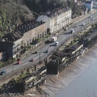
The Colonnade, the Rock House, St Vincent's Parade and the old landing stages for Campbell's paddle steamers. The leftover fruit of bygone boom years.
Bedminster Trip for New Walking Shoes
26 Feb 2022
I needed to buy new walking shoes—my old ones were squeaking and it was driving me up the wall—so I ordered some for collection from Taunton Leisure on East Street in Bedminster, and decided to make picking them up an official wander.
I didn't cover any new ground within my mile, but I did take advantage of the trip to take in a few interesting things just outside my normal radius, mostly New Gaol-related. Along the way there are a couple of sanitation-related diversions, including a visit to a rare manhole cover. You can hardly wait, I can tell!
In Which We Begin and End with Love
05 Mar 2022
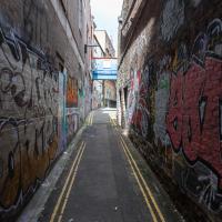
I had a lot to get done around the house, so as soon as I heard there might be a shiny new piece of street art near me, under the Cumberland Basin flyovers, I immediately decided that was all the excuse I needed to set off on a round-the-harbour lunchtime walk to get some fresh air and see if I could spot it. So, here's a circular wander that takes in graffiti, boats, wildlife and graffiti again...
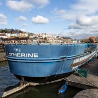
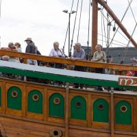
Not much change since the last time I saw her, but certainly a heck of a difference from the start of the "refit".
I mostly went out to hang out with my friends Sarah and Vik in Bedminster, but along the way I thought I'd take a closer look at something a little nearer home: the last crossing point of the Rownham Ferry.
In the distance is EE's temporary cell tower, which I've mentioned before, put up in November 2020.
Inflating in the field behind Ashton Court mansion, by the looks of it, the usual venue for the Balloon Fiesta.
I noticed I had a few things on my "potential wanders" list that could all be done relatively close to home, and in a fairly straight line, so I set off at lunchtime to recreate a photo of a now-defunct pub, wander behind a Spar (which turned out to be more interesting than I'd expected, but I admit it's a low bar) and spend some time browsing in Dreadnought Books before coming home via a coffee from Spoke & Stringer, a little diversion up Gasworks Lane and a tiny bit of the Rownham Mead estate I'd somehow previously skipped.
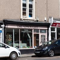
On St George's Road. This is where I ended up spending most of my stopping time on the walk. I managed to resist most temptations and came away having only spent £2 on a paperback of The Mill on the Floss. I read Silas Marner a while back and really liked it, so I've been wanting to try some more Eliot.
I shall add it to my tsundoku collection.
A Swing of the Plimsoll Bridge
24 Apr 2022
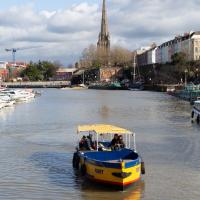
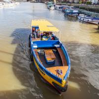
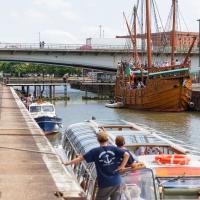
I was originally going to head over to the Ashton area to see if I'd missed any bits around the football stadium—and also to grab some lunch from the Tobacco Factory Market—but in the end I got a little distracted by having accidentally chosen exactly the right time to see the Plimsoll Bridge swing on one of the first busy days of Spring, where a lot of pleasure trips tend to head out down the Avon (and possibly the New Cut) from Hotwells.
In the end I mostly snapped that, and just a couple of photos from the Ashton area where I grabbed some lunch but didn't do any new exploring.
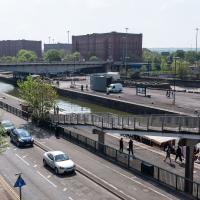
My first hint that there might be something interesting to look at was that the lock gates that I was planning on walking over were open rather than closed. Then I spotted the pleasure boat in the lock, just behind the descending steps from the footbridge there.
I've been pretty awful at reading so far this year, apparently averaging about one book per month. That's a far cry from 2019, say, where I got through 41 books in the year. Today's wander was prompted by my rubbish reading, as I needed to go hand back some books to the library, because I'd managed to renew them so many times that I hit the limit on renewals. Oops. Several of them were still unread.
So, off to the Central Library for me, tail between my legs. On the way there I did my best to recreate a historical photo of Dowry Square; while I was in the area I walked under the adjacent Norman arch and poked around behind the Cathedral, and I also had a little diversion to the city centre and came back along the south side of the river, hitting some trouble with the lock gates as I finally crossed the harbour back towards home.
The same view these days is a lot less romantic, especially with the temporary crate from some roadworks sitting at the corner of the square.
I don't blame anyone who lives this close to the Hotwell Road (and can't get double glazing fitted because it wouldn't be in keeping with the character) for wanting a lot of trees and bushes in between them and the roar of the traffic, but I think it's objectively a lot less appealing to the eye with so much shrubbery in the way. Probably good for the local wildlife, though.
It's less obstructive in winter, as you can see from this earlier photo taken from the back of the square looking back toward me.
Samuel Taylor Coleridge and Robert Southey both spent time in the garden of the square, apparently—I wonder what they'd make of it today?
For now, though, I escaped the hustle and bustle of Wapping Wharf by crossing Gaol Ferry Bridge—soon to be closed for "at least six to nine months" much to the distress of local businesses. And I imagine the local businesses know what the Council normally mean by "six to nine months": somewhere between two and three years would be my guess.
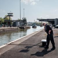
As a pedestrian I have a few alternative routes to cross. I decided to stroll down to the outer lock gate and get back to my side of the harbour there rather than going the long way around over the Plimsoll Bridge.
In the distance you can see a lockkeeper fishing in the water with a grappling hook on the end of some blue line to see if he can figure out what the gate is fouling on.